

Cumbres de Monterrey National Park
Encyclopedia
The Cumbres de Monterrey is national park of Mexico
located in the northern portion of the Sierra Madre Oriental
near the city of Monterrey
, Nuevo León
. The park includes the famous symbol of Monterrey, the signature skyline known as Cerro de la Silla
(Saddle Mountain). The park consists of rugged terrain boasting steep mountains reaching an elevation of 2,260 meters (7,410 feet) above sea level, deep canyons, rivers and waterfalls.
It was created in 1939 under president Lázaro Cárdenas
. The park encompasses 177,395.95 hectares (438,354.9 acres); it was created to protect the native flora and fauna against the spreading urbanization of the city of Monterrey
. The cool pine-oak forests with winding trails through the mountains make this park a popular escape from the Monterrey
metropolis.
inhabited the present area of Cumbres de Monterrey. Many of the different tribes in the region united for years in efforts to avoid Spanish rule. The first European settlement in the area was Monterrey on September 20, 1596.
Cumbres de Monterrey National Park was established on November 24, 1939 by president Lázaro Cárdenas
. The park was decreed to encompass 246,500 hectares (607,880 acres) which at the time was the largest area to be declared protected by the Mexican federal government under the regulations of a national park
. By decree on November 17, 2000 Cumbres de Monterrey National Park was reduced to an area of 177,395.95 hectares (438,354.9 acres).
 The most accessible portion of Cumbres de Monterrey National Park is Chipinque on the edge of Monterrey
about 12 miles from downtown. At the visitor's center, park officials provide information and maps of several hiking paths varying from easy to moderately-difficult. Chipinque is an ecological reserve within the park that allow visitors easy access to many of the flora and fauna found in the park.
The Cumbres de Monterrey National Park is located in the northern portion of the Sierra Madre Oriental
was formed by rock folding
of marine based sedimentary strata during the Eocene
epoch in the Laramide orogeny
period. The marine sedimentary rock rose over the years to an elevation of 2260 m (7,410 ft) above sea level.
The Highest Peaks in the Cumbres del Monterrey National Park
The main sedimentary rock that constitutes the mountains in the park was formed during the Cretaceous
. Most of the sedimentary rock has extensive karstification
that happened over millions of years creating several underground systems like: subterranean rivers, caves, and aquifers. Grutas de García
(García Caves) is one of the largest cave system in Mexico and is one of the most popular attractions within the park. García Caves were hidden for millions of years until being discovered in 1843. Marine fossils have been discovered inside these caves because the lining of the caves mainly consist of oceanic sedimentary rock.
The porous sedimentary rock in the park allows water to filter into subterranean rivers that replenish underground aquifers which provides one of the primary sources of water for the city of Monterrey
. Pozo del Gavilán (Eagle's Hole), the only cenote
known in northern Mexico is located in the southern tip of the park; it is another prime example of karstification
. Pozo del Gavilán is subterraneously connected to Laguna de Labradores (Labradores Lake). Eagle's Hole is a popular site to repel
.
Cañón de la Huasteca the most famous of the many canyons found in Cumbres de Monterrey National Park. The canyon accounts for about 200 hectares of the park. The walls of Cañón de la Huastecan are marked with a significant number prehistoric glyphs created thousands of years ago by the ancient inhabitants of the region. Another popular canyon is Matacanes Canyon where there are several waterfalls of which Cascada de Chipitín (Chipitín Falls) is the most famous.
Throughout the park there are numerous waterfalls, and there may be more to be found because there is an extensive cave system large amounts of water is not drained by surface streams and rivers but subtarrean ones. The two most famous waterfalls are Cascada Cola de Caballo
(Horsetail Falls) and Cascada de Chipitín (Chipitín Falls). Easily accessible by a trail, Horsetail Falls is one of the highlights of the park with a spectacular 25 m (82 ft) drop; the water pours over large rounded boulders creating a waterfall that resembles a horse's tail. Chipitín Falls is not easily accessible and requires a difficult hike, some repelling, and swimming; the waterfall has an impressive 27 m (88.5 ft) drop. In addition to the many surface streams and rivers there are many ponds and small lakes. The best known lake is Laguna de Labradores.
there are several climates within the park. The following climates are listed by elevation in the park.
Elevation 600-1,000 m (1,968-3,280 ft): North tip of the park has a (BWh) desert climate with an average annual temperature of 23°C (74°F) and an annual precipitation of 21.7 cm (8.5 in). The southeast corner and central east portion of the park has a (Awh) Tropical Savanna climate with mild winters, summer-autumn monsoon, annual precipitation of 106.4 cm (42 in), and an average annual temperature of 21°C (70°F).
Elevation 1,000-2,000 m (3,280-6,560 ft): North tip and the southwest corner of the park has a (BSk) Steppe Climate with an average annual temperature 21°C (70°F). Central portion of the park has a (Cwa) Humid Subtropical climate with an average annual temperature of 21°C (70°F) and an annual precipitation of 62 cm (25 in).
Elevation 2,000-3,000 m (6,560-9,840 ft):Western side of the park has a (Cwb) Oceanic climate with an average annual temperature of 14°C (57°F) and an annual precipitation of 68 cm (27 in).
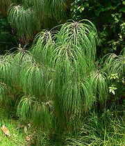
_harrier.jpg) The Cumbres de Monterrey National Park has a great variety of ecosystems throughout the park due to the geography of the park where there are many microclimates allowing a greater variety of flora and fauna to flourish. Agave
The Cumbres de Monterrey National Park has a great variety of ecosystems throughout the park due to the geography of the park where there are many microclimates allowing a greater variety of flora and fauna to flourish. Agave
, Dasylirion
, and Rhus species are found in many areas of the park. The forest is made up mainly of the following tree species:
The pine and oak forests and steppe are home to many animals. The Cumbres de Monterrey National Park has one of the most diverse ecosystems in the northern part of Mexico. There is a large variety of fish that can be found in the park, but most species are endangered.
The following fish species are present in the park: Astyanax mexicanus, Campostoma anomalum
, Cichlasoma cyanoguttatum, Cyprinella lutrensis, Etheostoma grahami, Gambusia affinis, Macrhybopsis aestivalis, Notropis amabilis, Notropis braytoni, Notropis stramineus, Poecilia mexicana, Puntius conchonius, and Xiphophorus couchianus. Even though there are many species of fish, the follow are the only known endemic species: Cyprinella rutila, Dionda melanops and Moxostoma albidum. A significant number of Cyprinodon
species still exists but many are endangered and many have gone extinct.
The park hosts a large variety of avian species; the following bird species are the most notable: Accipiter striatus, Aquila chrysaetos, Circus cyaneus, Falco columbarius, Falco mexicanus, Falco peregrinus, Rhynchopsitta terrisi, Speotyto cunicularia, and Spizella wortheni'.
The park also has a significant number of mammals, the following are a few of the species found in the park: Puma concolor, Ursus americanus, Canis latrans, and Odocoileus virginianus.
Mexico
The United Mexican States , commonly known as Mexico , is a federal constitutional republic in North America. It is bordered on the north by the United States; on the south and west by the Pacific Ocean; on the southeast by Guatemala, Belize, and the Caribbean Sea; and on the east by the Gulf of...
located in the northern portion of the Sierra Madre Oriental
Sierra Madre Oriental
The Sierra Madre Oriental is a mountain range in northeastern Mexico.-Setting:Spanning the Sierra Madre Oriental runs from Coahuila south through Nuevo León, southwest Tamaulipas, San Luis Potosí, Querétaro, and Hidalgo to northern Puebla, where it joins with the east-west running Eje Volcánico...
near the city of Monterrey
Monterrey
Monterrey , is the capital city of the northeastern state of Nuevo León in the country of Mexico. The city is anchor to the third-largest metropolitan area in Mexico and is ranked as the ninth-largest city in the nation. Monterrey serves as a commercial center in the north of the country and is the...
, Nuevo León
Nuevo León
Nuevo León It is located in Northeastern Mexico. It is bordered by the states of Tamaulipas to the north and east, San Luis Potosí to the south, and Coahuila to the west. To the north, Nuevo León has a 15 kilometer stretch of the U.S.-Mexico border adjacent to the U.S...
. The park includes the famous symbol of Monterrey, the signature skyline known as Cerro de la Silla
Cerro de la Silla
Cerro de la Silla , named for its distinctive saddle-shaped profile when viewed from the west, is a famous symbol of the landscape of the state of Nuevo León, Mexico. Even though the mountain itself is located in the adjacent city of Guadalupe, it is widely associated to the city of Monterrey,...
(Saddle Mountain). The park consists of rugged terrain boasting steep mountains reaching an elevation of 2,260 meters (7,410 feet) above sea level, deep canyons, rivers and waterfalls.
It was created in 1939 under president Lázaro Cárdenas
Lázaro Cárdenas
Lázaro Cárdenas del Río was President of Mexico from 1934 to 1940.-Early life:Lázaro Cárdenas was born on May 21, 1895 in a lower-middle class family in the village of Jiquilpan, Michoacán. He supported his family from age 16 after the death of his father...
. The park encompasses 177,395.95 hectares (438,354.9 acres); it was created to protect the native flora and fauna against the spreading urbanization of the city of Monterrey
Monterrey
Monterrey , is the capital city of the northeastern state of Nuevo León in the country of Mexico. The city is anchor to the third-largest metropolitan area in Mexico and is ranked as the ninth-largest city in the nation. Monterrey serves as a commercial center in the north of the country and is the...
. The cool pine-oak forests with winding trails through the mountains make this park a popular escape from the Monterrey
Monterrey
Monterrey , is the capital city of the northeastern state of Nuevo León in the country of Mexico. The city is anchor to the third-largest metropolitan area in Mexico and is ranked as the ninth-largest city in the nation. Monterrey serves as a commercial center in the north of the country and is the...
metropolis.
History
There are numerous indigenous paintings and stone carvings throughout the park that have proven humans have inhabited the area for thousands of years. Before the Spanish Colonial Period, different groups of ChichimecaChichimeca
Chichimeca was the name that the Nahua peoples of Mexico generically applied to a wide range of semi-nomadic peoples who inhabited the north of modern-day Mexico and southwestern United States, and carried the same sense as the European term "barbarian"...
inhabited the present area of Cumbres de Monterrey. Many of the different tribes in the region united for years in efforts to avoid Spanish rule. The first European settlement in the area was Monterrey on September 20, 1596.
Cumbres de Monterrey National Park was established on November 24, 1939 by president Lázaro Cárdenas
Lázaro Cárdenas
Lázaro Cárdenas del Río was President of Mexico from 1934 to 1940.-Early life:Lázaro Cárdenas was born on May 21, 1895 in a lower-middle class family in the village of Jiquilpan, Michoacán. He supported his family from age 16 after the death of his father...
. The park was decreed to encompass 246,500 hectares (607,880 acres) which at the time was the largest area to be declared protected by the Mexican federal government under the regulations of a national park
National park
A national park is a reserve of natural, semi-natural, or developed land that a sovereign state declares or owns. Although individual nations designate their own national parks differently A national park is a reserve of natural, semi-natural, or developed land that a sovereign state declares or...
. By decree on November 17, 2000 Cumbres de Monterrey National Park was reduced to an area of 177,395.95 hectares (438,354.9 acres).
Geography
Monterrey
Monterrey , is the capital city of the northeastern state of Nuevo León in the country of Mexico. The city is anchor to the third-largest metropolitan area in Mexico and is ranked as the ninth-largest city in the nation. Monterrey serves as a commercial center in the north of the country and is the...
about 12 miles from downtown. At the visitor's center, park officials provide information and maps of several hiking paths varying from easy to moderately-difficult. Chipinque is an ecological reserve within the park that allow visitors easy access to many of the flora and fauna found in the park.
The Cumbres de Monterrey National Park is located in the northern portion of the Sierra Madre Oriental
Sierra Madre Oriental
The Sierra Madre Oriental is a mountain range in northeastern Mexico.-Setting:Spanning the Sierra Madre Oriental runs from Coahuila south through Nuevo León, southwest Tamaulipas, San Luis Potosí, Querétaro, and Hidalgo to northern Puebla, where it joins with the east-west running Eje Volcánico...
was formed by rock folding
Fold (geology)
The term fold is used in geology when one or a stack of originally flat and planar surfaces, such as sedimentary strata, are bent or curved as a result of permanent deformation. Synsedimentary folds are those due to slumping of sedimentary material before it is lithified. Folds in rocks vary in...
of marine based sedimentary strata during the Eocene
Eocene
The Eocene Epoch, lasting from about 56 to 34 million years ago , is a major division of the geologic timescale and the second epoch of the Paleogene Period in the Cenozoic Era. The Eocene spans the time from the end of the Palaeocene Epoch to the beginning of the Oligocene Epoch. The start of the...
epoch in the Laramide orogeny
Laramide orogeny
The Laramide orogeny was a period of mountain building in western North America, which started in the Late Cretaceous, 70 to 80 million years ago, and ended 35 to 55 million years ago. The exact duration and ages of beginning and end of the orogeny are in dispute, as is the cause. The Laramide...
period. The marine sedimentary rock rose over the years to an elevation of 2260 m (7,410 ft) above sea level.
The Highest Peaks in the Cumbres del Monterrey National Park
- Pinar: 1,515 m (4,970 ft) above sea level
- La Ventana: 1,955 m (6,415 ft) above sea level
- La Antenna: 2,015 m (6,610 ft) above sea level
- M Este: 2,020 m (6,630 ft) above sea level
- Copete de las Águilas: 2260 m (7,410 ft) above sea level
The main sedimentary rock that constitutes the mountains in the park was formed during the Cretaceous
Cretaceous
The Cretaceous , derived from the Latin "creta" , usually abbreviated K for its German translation Kreide , is a geologic period and system from circa to million years ago. In the geologic timescale, the Cretaceous follows the Jurassic period and is followed by the Paleogene period of the...
. Most of the sedimentary rock has extensive karstification
Karst topography
Karst topography is a geologic formation shaped by the dissolution of a layer or layers of soluble bedrock, usually carbonate rock such as limestone or dolomite, but has also been documented for weathering resistant rocks like quartzite given the right conditions.Due to subterranean drainage, there...
that happened over millions of years creating several underground systems like: subterranean rivers, caves, and aquifers. Grutas de García
Grutas de García
Grutas de García are located 9 kilometers outside the small town of García, Nuevo León in northern Mexico about 30 km from Monterrey. The caves are inside the famous mountain, El Fraile within the Cumbres de Monterrey National Park....
(García Caves) is one of the largest cave system in Mexico and is one of the most popular attractions within the park. García Caves were hidden for millions of years until being discovered in 1843. Marine fossils have been discovered inside these caves because the lining of the caves mainly consist of oceanic sedimentary rock.
The porous sedimentary rock in the park allows water to filter into subterranean rivers that replenish underground aquifers which provides one of the primary sources of water for the city of Monterrey
Monterrey
Monterrey , is the capital city of the northeastern state of Nuevo León in the country of Mexico. The city is anchor to the third-largest metropolitan area in Mexico and is ranked as the ninth-largest city in the nation. Monterrey serves as a commercial center in the north of the country and is the...
. Pozo del Gavilán (Eagle's Hole), the only cenote
Cenote
A cenote is a deep natural pit, or sinkhole, characteristic of Mexico and Central America, resulting from the collapse of limestone bedrock that exposes groundwater underneath...
known in northern Mexico is located in the southern tip of the park; it is another prime example of karstification
Karst topography
Karst topography is a geologic formation shaped by the dissolution of a layer or layers of soluble bedrock, usually carbonate rock such as limestone or dolomite, but has also been documented for weathering resistant rocks like quartzite given the right conditions.Due to subterranean drainage, there...
. Pozo del Gavilán is subterraneously connected to Laguna de Labradores (Labradores Lake). Eagle's Hole is a popular site to repel
Repel
Repel is a commune in the Vosges department in Lorraine in northeastern France....
.
Cañón de la Huasteca the most famous of the many canyons found in Cumbres de Monterrey National Park. The canyon accounts for about 200 hectares of the park. The walls of Cañón de la Huastecan are marked with a significant number prehistoric glyphs created thousands of years ago by the ancient inhabitants of the region. Another popular canyon is Matacanes Canyon where there are several waterfalls of which Cascada de Chipitín (Chipitín Falls) is the most famous.
Throughout the park there are numerous waterfalls, and there may be more to be found because there is an extensive cave system large amounts of water is not drained by surface streams and rivers but subtarrean ones. The two most famous waterfalls are Cascada Cola de Caballo
Cola de Caballo
Cola de Caballo is a waterfall about 40 km from Monterrey, Mexico, in the town of Villa de Santiago, Nuevo León. It is open to the public and is accessible via a walking path.- References :*...
(Horsetail Falls) and Cascada de Chipitín (Chipitín Falls). Easily accessible by a trail, Horsetail Falls is one of the highlights of the park with a spectacular 25 m (82 ft) drop; the water pours over large rounded boulders creating a waterfall that resembles a horse's tail. Chipitín Falls is not easily accessible and requires a difficult hike, some repelling, and swimming; the waterfall has an impressive 27 m (88.5 ft) drop. In addition to the many surface streams and rivers there are many ponds and small lakes. The best known lake is Laguna de Labradores.
Climate
The climate throughout the park changes drastically depending on the elevation and the location of the terrain. According to the Köppen climate classificationKöppen climate classification
The Köppen climate classification is one of the most widely used climate classification systems. It was first published by Crimea German climatologist Wladimir Köppen in 1884, with several later modifications by Köppen himself, notably in 1918 and 1936...
there are several climates within the park. The following climates are listed by elevation in the park.
Elevation 600-1,000 m (1,968-3,280 ft): North tip of the park has a (BWh) desert climate with an average annual temperature of 23°C (74°F) and an annual precipitation of 21.7 cm (8.5 in). The southeast corner and central east portion of the park has a (Awh) Tropical Savanna climate with mild winters, summer-autumn monsoon, annual precipitation of 106.4 cm (42 in), and an average annual temperature of 21°C (70°F).
Elevation 1,000-2,000 m (3,280-6,560 ft): North tip and the southwest corner of the park has a (BSk) Steppe Climate with an average annual temperature 21°C (70°F). Central portion of the park has a (Cwa) Humid Subtropical climate with an average annual temperature of 21°C (70°F) and an annual precipitation of 62 cm (25 in).
Elevation 2,000-3,000 m (6,560-9,840 ft):Western side of the park has a (Cwb) Oceanic climate with an average annual temperature of 14°C (57°F) and an annual precipitation of 68 cm (27 in).
Flora and fauna
Agave
Agave is a genus of monocots. The plants are perennial, but each rosette flowers once and then dies ; they are commonly known as the century plant....
, Dasylirion
Dasylirion
Dasylirion is a genus of 17 species of flowering plants, all native to Mexico, with three species also extending into the southwestern United States...
, and Rhus species are found in many areas of the park. The forest is made up mainly of the following tree species:
- SpruceSpruceA spruce is a tree of the genus Picea , a genus of about 35 species of coniferous evergreen trees in the Family Pinaceae, found in the northern temperate and boreal regions of the earth. Spruces are large trees, from tall when mature, and can be distinguished by their whorled branches and conical...
: Picea martinezii, Picea engelmannii - YuccaYuccaYucca is a genus of perennial shrubs and trees in the family Asparagaceae, subfamily Agavoideae. Its 40-50 species are notable for their rosettes of evergreen, tough, sword-shaped leaves and large terminal panicles of white or whitish flowers. They are native to the hot and dry parts of North...
: Yucca carnerosana, Yucca filifera - Douglass Fir: Pseudotsuga lindleyanaPseudotsuga lindleyanaPseudotsuga lindleyana, commonly known as the Mexican Douglas-fir, is a species of conifer in the genus Pseudotsuga. It is native to the Sierra Madre Occidental and the Sierra Madre Oriental ranges of Mexico.-External links:...
, Pseudotsuga flahualti - FirsFIRSThe FIRS Index is a share index of the 13 privatisation-investment funds listed on the Banja Luka Stock Exchange , established on 29 July 2004...
: Abies vejariiAbies vejariiAbies vejarii is a species of fir native to northeastern Mexico, in the states of Coahuila and Nuevo León, where it grows at high altitudes in the Sierra Madre Oriental.It is a medium-sized evergreen tree growing to 35–40 m tall...
, Abies hickeliiAbies hickeliiAbies hickelii is a species of conifer in the Pinaceae family.It is found only in Mexico.-References:* Conifer Specialist Group 1998. . Downloaded on 10 July 2007....
, Abies hidalgensisAbies hidalgensisAbies hidalgensis is a species of conifer in the Pinaceae family.It is found only in Mexico.-Source:* Conifer Specialist Group 1998. . Downloaded on 10 July 2007....
, Abies durangensisAbies durangensisAbies durangensis is a species of conifer in the Pinaceae family. It was described botanically by Maximino Martínez in 1942 and is found only in Mexico .... - OakOakAn oak is a tree or shrub in the genus Quercus , of which about 600 species exist. "Oak" may also appear in the names of species in related genera, notably Lithocarpus...
: Quercus fusiformis, Quercus greggii, Quercus hipoxlanta, Quercus laeta, Quercus saltillensis - PinePinePines are trees in the genus Pinus ,in the family Pinaceae. They make up the monotypic subfamily Pinoideae. There are about 115 species of pine, although different authorities accept between 105 and 125 species.-Etymology:...
: Pinus ayacahuite, Pinus cembroides, Pinus greggiiPinus greggiiPinus greggii, or Gregg's pine, is a small to medium high pine tree native to eastern Mexico, found in two distinct regions. It has an open crown and long and slender branches. The needles are in bundles of three with an average length of 11 cm. The cones are clustered in groups of 5 – 10....
, Pinus hartwegii, Pinus pinceanaPinus pinceanaWeeping Pinyon is a species of conifer in the Pinaceae family.It is found only in Mexico.It is threatened by habitat loss.-Source:* Conifer Specialist Group 1998. . Downloaded on 10 July 2007....
, Pinus pseudostrobusPinus pseudostrobusSmooth-bark Mexican Pine , distinctive names in Spanish, tree endemic to Mexico.It is 8 to 25 m tall, dense and round top, the bark is brown and fissured and smooth when young. It grows between 1300-3250 m. From 26° to 15° north latitude, from Sinaloa, Mexico to Honduras. It occurs within a...
, Pinus rudis, Pinus teocotePinus teocotePinus teocote is a species of conifer in the Pinaceae family.It is found only in Mexico. 20-30 m tall and 75 cm diameter. Straight trunk and dense top. It grows at 1500-3200 mm...
The pine and oak forests and steppe are home to many animals. The Cumbres de Monterrey National Park has one of the most diverse ecosystems in the northern part of Mexico. There is a large variety of fish that can be found in the park, but most species are endangered.
The following fish species are present in the park: Astyanax mexicanus, Campostoma anomalum
Campostoma anomalum
-Introduction:This is a description of a monitoring plan that has been laid out for a commonly known species Campostoma anomalum or Central Stoneroller...
, Cichlasoma cyanoguttatum, Cyprinella lutrensis, Etheostoma grahami, Gambusia affinis, Macrhybopsis aestivalis, Notropis amabilis, Notropis braytoni, Notropis stramineus, Poecilia mexicana, Puntius conchonius, and Xiphophorus couchianus. Even though there are many species of fish, the follow are the only known endemic species: Cyprinella rutila, Dionda melanops and Moxostoma albidum. A significant number of Cyprinodon
Cyprinodon
Cyprinodon is a genus of small killifish belonging to the family Cyprinodontidae of ray-finned fish.-Species:* Whitefin pupfish, Cyprinodon albivelis Minckley & Miller, 2002.* Potosi pupfish, Cyprinodon alvarezi Miller, 1976....
species still exists but many are endangered and many have gone extinct.
The park hosts a large variety of avian species; the following bird species are the most notable: Accipiter striatus, Aquila chrysaetos, Circus cyaneus, Falco columbarius, Falco mexicanus, Falco peregrinus, Rhynchopsitta terrisi, Speotyto cunicularia, and Spizella wortheni'.
The park also has a significant number of mammals, the following are a few of the species found in the park: Puma concolor, Ursus americanus, Canis latrans, and Odocoileus virginianus.