
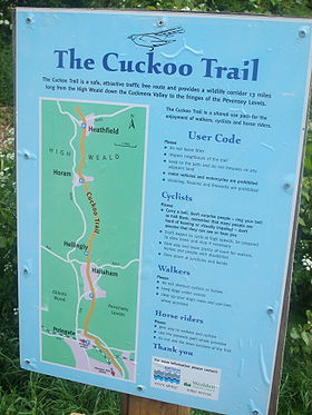
Cuckoo Trail
Encyclopedia
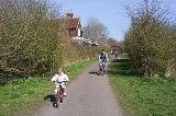
The Cuckoo Trail is an 14 miles (22.5 km) footpath and cycleway which runs from Hampden Park
to Heathfield
in East Sussex
. It passes through the towns of Polegate
and Hailsham
, as well as the villages of Hellingly
and Horam
.
, which opened in 1880 and ran between Eridge
and Polegate
railway stations, creating a direct route between Eastbourne
and London
. It obtained its name from the tradition that the first cuckoo
in Spring was heard at the Heathfield Fair. The line closed in 1968 under the programme of closures
put forward by Forest Row
resident and British Transport Commission
Chairman Richard Beeching
.
 In 1981 the route of the old railway line to the south of Heathfield was purchased by Wealden District Council and East Sussex County Council. From 1990 Sustrans
developed the route along with District Council and the County Council into a shared track for walkers and cyclists, with horses also allowed on some sections. An extension was constructed to the south into Eastbourne and the trail became part of National Cycle Network
Route 21
. The Trail is currently used by around 200,000 people per year and serves as a traffic-free route between several local schools. It is jointly managed by the latter in conjunction with East Sussex County Council.
Along the route of the Trail are six original sculptures which act as mileposts. In May 1993 a dozen wooden benches were installed which had been handcarved by a local artist out of trees felled during the Great Storm of 1987
. In 2003 a five-year £65,000 package of grants for improvements to the Cuckoo Trail was awarded as part of the Woodland Grant Scheme. Part of these funds went towards the resurfacing of the Trail as far as Heathfield in October 2006.
The Trail is therefore re-routed from Heathfield over nearby roads, diverging from the railway alignment to join the A265 Mutton Hall Hill before heading north on Newick Lane through Mayfield town centre. This route has caused controversy amongst local residents.
The inability to extend the Trail north means that it cannot reach Groombridge
and link with the Forest Way
, another footpath and bridleway following the route of a disused railway line. Numerous reports have been prepared which identified various routes which would connect with the Forest Way, from a Sustrans report in 1995 to three Owen Williams reports in 1998 and 1999, and finally an Atkins feasibility study in 2006 which confirmed that reusing the old railway line would be the best way forward, with the alternative on-road route as a short-term means of access to Groombridge.
As part of the extension north, the 240 metre Heathfield Tunnel was repaired and restored in 1997, funded by a derelict land grant of £198,000 by English Partnerships
and a contribution of £60,000 from Wealden District Council. Gates were fitted to the tunnel in 1999 at a cost of £22,000 which allowed access to be restricted to daylight hours; access became unrestricted from 2002 but ceased entirely following an alleged rape incident on 12 March 2005. A trial reopening period began on 26 March 2007.
Hampden Park, East Sussex
Hampden Park is a suburb of Eastbourne. It is notable for its unique railway station, where local trains on the East Coastway Line stop twice, and is thought to be the busiest level crossing in the country. This station, now known as Hampden Park station, was once named 'Willingdon...
to Heathfield
Heathfield, East Sussex
Heathfield is a small market town, and the principal settlement in the civil parish of Heathfield and Waldron in the Wealden District of East Sussex, within the historic County of Sussex, England.-Location:...
in East Sussex
East Sussex
East Sussex is a county in South East England. It is bordered by the counties of Kent, Surrey and West Sussex, and to the south by the English Channel.-History:...
. It passes through the towns of Polegate
Polegate
Polegate is a town and civil parish in the Wealden District of East Sussex, England, United Kingdom. It is located five miles north of the seaside resort of Eastbourne, and is part of the greater area of that town. Although once a railway settlement, its importance as such has now waned with...
and Hailsham
Hailsham
Hailsham is a civil parish and the largest of the five main towns in the Wealden district of East Sussex, England. Mentioned in the Domesday Book, the town of Hailsham has had a long history of industry and agriculture...
, as well as the villages of Hellingly
Hellingly
Hellingly is a village and civil parish in the Wealden District of East Sussex, England. The village is located 1.5 miles north of Hailsham.The nearby village of Lower Dicker is located within the parish.-History:...
and Horam
Horam
Horam is a village and civil parish in the Wealden District of East Sussex, situated three miles south of Heathfield. Included in the parish are the settlements of Vines Cross and Burlow.-History:...
.
History
The Trail largely follows the route of a disused railway line, the Cuckoo LineCuckoo Line
The Cuckoo Line is an informal name for the now defunct railway service which linked Polegate and Eridge in East Sussex, England, from 1880 to 1968. It was nicknamed the Cuckoo Line by drivers, from a tradition observed at the annual fair at Heathfield, a station on the route...
, which opened in 1880 and ran between Eridge
Eridge railway station
Eridge railway station serves a rural district around Eridge in East Sussex. Mainline train services from the station are provided by Southern, and the station is on the Uckfield branch of the Oxted Line. Also heritage services connecting to Groombridge, High Rocks and Tunbridge Wells West are run...
and Polegate
Polegate railway station
Polegate railway station serves Polegate in East Sussex, England. It is on the East Coastway Line, and train services are provided by Southern.-First Station:...
railway stations, creating a direct route between Eastbourne
Eastbourne
Eastbourne is a large town and borough in East Sussex, on the south coast of England between Brighton and Hastings. The town is situated at the eastern end of the chalk South Downs alongside the high cliff at Beachy Head...
and London
London
London is the capital city of :England and the :United Kingdom, the largest metropolitan area in the United Kingdom, and the largest urban zone in the European Union by most measures. Located on the River Thames, London has been a major settlement for two millennia, its history going back to its...
. It obtained its name from the tradition that the first cuckoo
Cuckoo
The cuckoos are a family, Cuculidae, of near passerine birds. The order Cuculiformes, in addition to the cuckoos, also includes the turacos . Some zoologists and taxonomists have also included the unique Hoatzin in the Cuculiformes, but its taxonomy remains in dispute...
in Spring was heard at the Heathfield Fair. The line closed in 1968 under the programme of closures
Beeching Axe
The Beeching Axe or the Beeching Cuts are informal names for the British Government's attempt in the 1960s to reduce the cost of running British Railways, the nationalised railway system in the United Kingdom. The name is that of the main author of The Reshaping of British Railways, Dr Richard...
put forward by Forest Row
Forest Row
Forest Row is a village and relatively large civil parish in the Wealden District of East Sussex, England. The village is located three miles south-east of East Grinstead.-History:...
resident and British Transport Commission
British Transport Commission
The British Transport Commission was created by Clement Attlee's post-war Labour government as a part of its nationalisation programme, to oversee railways, canals and road freight transport in Great Britain...
Chairman Richard Beeching
Richard Beeching
Richard Beeching, Baron Beeching , commonly known as Doctor Beeching, was chairman of British Railways and a physicist and engineer...
.
Sustrans
Sustrans is a British charity to promote sustainable transport. The charity is currently working on a number of practical projects to encourage people to walk, cycle and use public transport, to give people the choice of "travelling in ways that benefit their health and the environment"...
developed the route along with District Council and the County Council into a shared track for walkers and cyclists, with horses also allowed on some sections. An extension was constructed to the south into Eastbourne and the trail became part of National Cycle Network
National Cycle Network
The National Cycle Network is a network of cycle routes in the United Kingdom.The National Cycle Network was created by the charity Sustrans , and aided by a £42.5 million National Lottery grant. In 2005 it was used for over 230 million trips.Many routes hope to minimise contact with motor...
Route 21
National Cycle Route 21
National Cycle Route 21 is part of the United Kingdom's National Cycle Network. It runs from Greenwich in South-East London south to Crawley, then east to Groombridge and south to Eastbourne, with a short final loop northwards again to its end at Pevensey....
. The Trail is currently used by around 200,000 people per year and serves as a traffic-free route between several local schools. It is jointly managed by the latter in conjunction with East Sussex County Council.
Along the route of the Trail are six original sculptures which act as mileposts. In May 1993 a dozen wooden benches were installed which had been handcarved by a local artist out of trees felled during the Great Storm of 1987
Great Storm of 1987
The Great Storm of 1987 occurred on the night of 15/16 October 1987, when an unusually strong weather system caused winds to hit much of southern England and northern France...
. In 2003 a five-year £65,000 package of grants for improvements to the Cuckoo Trail was awarded as part of the Woodland Grant Scheme. Part of these funds went towards the resurfacing of the Trail as far as Heathfield in October 2006.
Extension north
As of 2008 the Cuckoo Trail remains incomplete insofar as the remaining section of the disused railway line north of Heathfield is largely inaccessible and in the ownership of 12 different individuals who have resisted attempts to establish a path/cycleway over their land. Until 1986 East Sussex County Council had 11 miles of the Cuckoo Trail to the south of Mayfield within its ownership but, seeking to reduce expenditure, it abandoned the early ideas of reopening it as a public footpath, and parcels of land were sold off in a piecemeal fashion.The Trail is therefore re-routed from Heathfield over nearby roads, diverging from the railway alignment to join the A265 Mutton Hall Hill before heading north on Newick Lane through Mayfield town centre. This route has caused controversy amongst local residents.
The inability to extend the Trail north means that it cannot reach Groombridge
Groombridge
thumb|right|A house in GroombridgeGroombridge is a village of about 1,600 people. It straddles the border between Kent and East Sussex, in England. The nearest large town is Tunbridge Wells, about away by road....
and link with the Forest Way
Forest Way
The Forest Way is a linear Country park providing walking, cycling, horse riding and the quiet enjoyment of the countryside. It runs for around 16 km from East Grinstead to Groombridge....
, another footpath and bridleway following the route of a disused railway line. Numerous reports have been prepared which identified various routes which would connect with the Forest Way, from a Sustrans report in 1995 to three Owen Williams reports in 1998 and 1999, and finally an Atkins feasibility study in 2006 which confirmed that reusing the old railway line would be the best way forward, with the alternative on-road route as a short-term means of access to Groombridge.
As part of the extension north, the 240 metre Heathfield Tunnel was repaired and restored in 1997, funded by a derelict land grant of £198,000 by English Partnerships
English Partnerships
English Partnerships was the national regeneration agency for England, performing a similar role on a national level to that fulfilled by Regional Development Agencies on a regional level...
and a contribution of £60,000 from Wealden District Council. Gates were fitted to the tunnel in 1999 at a cost of £22,000 which allowed access to be restricted to daylight hours; access became unrestricted from 2002 but ceased entirely following an alleged rape incident on 12 March 2005. A trial reopening period began on 26 March 2007.