
Cresswell, Northumberland
Encyclopedia
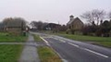
Cresswell is a village in Northumberland
Northumberland
Northumberland is the northernmost ceremonial county and a unitary district in North East England. For Eurostat purposes Northumberland is a NUTS 3 region and is one of three boroughs or unitary districts that comprise the "Northumberland and Tyne and Wear" NUTS 2 region...
, England. It is about 4 miles (6 km) to the north of Ashington
Ashington
Ashington is a town and civil parish in Northumberland, England with a population of around 27,000 people; it was once a centre of the coal mining industry. The town is located some north of Newcastle upon Tyne off the A189. The south of the town is bordered by the River Wansbeck...
, on the North Sea
North Sea
In the southwest, beyond the Straits of Dover, the North Sea becomes the English Channel connecting to the Atlantic Ocean. In the east, it connects to the Baltic Sea via the Skagerrak and Kattegat, narrow straits that separate Denmark from Norway and Sweden respectively...
coast.
It is a popular bird watching area with Cresswell pond and bird hide nearby and the Druridge Bay
Druridge Bay
Druridge Bay is a long coastal bay in Northumberland, England, stretching from Amble in the north to Cresswell in the south.Northumberland Coast Country Park is situated within the bay, and part of the bay is owned by the National Trust...
Country Park less than 3 miles (5 km) away.
The village has one ice cream shop which closes out of season. The village also has two caravan holiday home parks - Cresswell Towers and Golden Sands. Cresswell Towers takes its name from the old tower nearby.
Landmarks
Snab Point, 500 metres (1,640.4 ft) south of The Carrs, is a sheltered bay with the Alcan aluminium smelting plant on its south side. Embedded in the small cliffs of Snab Point are the remnants of fossilised trees. The beach area is littered with the remnants of fossilised wood and small seams of coal can be seen in the cliffs. Depending on the tides and wind, vast swathes of sea coal is washed up within the bay. The area was formed during the carboniferousCarboniferous
The Carboniferous is a geologic period and system that extends from the end of the Devonian Period, about 359.2 ± 2.5 Mya , to the beginning of the Permian Period, about 299.0 ± 0.8 Mya . The name is derived from the Latin word for coal, carbo. Carboniferous means "coal-bearing"...
period some 310 million years ago, when the current land mass was in a region below southern Spain
Spain
Spain , officially the Kingdom of Spain languages]] under the European Charter for Regional or Minority Languages. In each of these, Spain's official name is as follows:;;;;;;), is a country and member state of the European Union located in southwestern Europe on the Iberian Peninsula...
, more than 1000 miles (1,609.3 km) south of its present position.