
Cramahe, Ontario
Encyclopedia
Cramahe is a rural township
located in Northumberland County
in central Ontario
, Canada
.
Joseph Keeler opened a store on the site of present-day Colborne about 1819. A community began to grow as other small businessmen followed suit. With the opening of harbour facilities in the 1940 and the arrival of the railway in the 1850s, Colborne became an important service centre for the region. Cramahe was incorporated as a township in 1850. In 1858, the village of Colborne seceded from the municipality as a separate township. In 2001, the two municipalities were re-amalgamated to form an expanded Township of Cramahe.
Originally named Keeler's Creek, Colborne (44°00′20"N 77°53′20"W) was named after Sir John Colborne, Lieutenant Governor of Upper Canada, by Joseph Abbott Keeler in 1829. Colborne was incorporated as a village in 1858 with a population of approximately 700 people. In 2001, Colborne and Cramahe Township were amalgamated as part of municipal restructuring to form an expanded Township of Cramahe. At the time of dissolution, Colborne had a population of 2,040 over an area of 5.2 square kilometres.
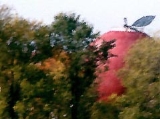
Colborne is the home of the "Big Apple," a tourist attraction located near Highway 401. With a height of 10.7 metres and diameter of 11.6 metres, the Big Apple is billed as the largest apple in the world. There is an observation deck on top of the apple, a restaurant and other amenities on the premises.
:
Population trend:
Township (Canada)
The term township generally means the district or area associated with a town. However in some systems no town needs to be involved. The specific use of the term to describe political subdivisions has varied by country, usually to describe a local rural or semi-rural government within the county...
located in Northumberland County
Northumberland County, Ontario
Northumberland County is situated on the north shore of Lake Ontario, in central Ontario, Canada. It is located east of Durham County , west of Hastings, southeast of Kawartha Lakes and south of Peterborough County. The county seat is Cobourg...
in central Ontario
Ontario
Ontario is a province of Canada, located in east-central Canada. It is Canada's most populous province and second largest in total area. It is home to the nation's most populous city, Toronto, and the nation's capital, Ottawa....
, Canada
Canada
Canada is a North American country consisting of ten provinces and three territories. Located in the northern part of the continent, it extends from the Atlantic Ocean in the east to the Pacific Ocean in the west, and northward into the Arctic Ocean...
.
Joseph Keeler opened a store on the site of present-day Colborne about 1819. A community began to grow as other small businessmen followed suit. With the opening of harbour facilities in the 1940 and the arrival of the railway in the 1850s, Colborne became an important service centre for the region. Cramahe was incorporated as a township in 1850. In 1858, the village of Colborne seceded from the municipality as a separate township. In 2001, the two municipalities were re-amalgamated to form an expanded Township of Cramahe.
Communities
The township comprises the communities of Castleton, Colborne, Dundonald, East Colborne, Edville, Greenleys Corners, Griffis Corners, Loughbreeze, Morganston, Purdy Corners, Salem, Shiloh, Tubbs Corners and Victoria Park.Originally named Keeler's Creek, Colborne (44°00′20"N 77°53′20"W) was named after Sir John Colborne, Lieutenant Governor of Upper Canada, by Joseph Abbott Keeler in 1829. Colborne was incorporated as a village in 1858 with a population of approximately 700 people. In 2001, Colborne and Cramahe Township were amalgamated as part of municipal restructuring to form an expanded Township of Cramahe. At the time of dissolution, Colborne had a population of 2,040 over an area of 5.2 square kilometres.
Colborne is the home of the "Big Apple," a tourist attraction located near Highway 401. With a height of 10.7 metres and diameter of 11.6 metres, the Big Apple is billed as the largest apple in the world. There is an observation deck on top of the apple, a restaurant and other amenities on the premises.
Demographics
According to the Canada 2006 CensusCanada 2006 Census
The Canada 2006 Census was a detailed enumeration of the Canadian population. Census day was May 16, 2006. The next census following will be the 2011 Census. Canada's total population enumerated by the 2006 census was 31,612,897...
:
- Population: 5,950
- % Change (2001-2006): +4.1%
- Area (km².): 201.56
- Density (persons per km².): 29.5
- Private dwellings occupied by usual residents: 2260 (total dwellings: 2548)
- Mother tongue:
- English as first language: 92.4 %
- French as first language: 0.9 %
- English and French as first language: 0.2 %
- Other as first language: 6.5 %
Population trend:
- Population in 2006: 5950
- Population in 2001: 5713
- Population in 1996:
- Cramahe (township): 3420
- Colborne (village): 2054
- Population in 1991:
- Cramahe (township): 3108
- Colborne (village): 2001