

Crag Cave
Encyclopedia
Republic of Ireland
Ireland , described as the Republic of Ireland , is a sovereign state in Europe occupying approximately five-sixths of the island of the same name. Its capital is Dublin. Ireland, which had a population of 4.58 million in 2011, is a constitutional republic governed as a parliamentary democracy,...
, located just outside Castleisland
Castleisland
Castleisland is a town and commercial centre in County Kerry in south west Ireland. The town is renowned for the width of its main street. Castleisland has a population of 2,170....
, County Kerry
County Kerry
Kerry means the "people of Ciar" which was the name of the pre-Gaelic tribe who lived in part of the present county. The legendary founder of the tribe was Ciar, son of Fergus mac Róich. In Old Irish "Ciar" meant black or dark brown, and the word continues in use in modern Irish as an adjective...
.
Formed in elevated limestone
Limestone
Limestone is a sedimentary rock composed largely of the minerals calcite and aragonite, which are different crystal forms of calcium carbonate . Many limestones are composed from skeletal fragments of marine organisms such as coral or foraminifera....
rock, the system extends to 3.8 kilometres (2.4 mi) of surveyed passage, on two levels. It is the 7th-longest cave system in the Republic of Ireland, and the 10th-longest in the whole of Ireland
Ireland
Ireland is an island to the northwest of continental Europe. It is the third-largest island in Europe and the twentieth-largest island on Earth...
.
Crag Cave runs under Castleisland itself, starting at Glounsharoon and ending on the far side of town at the Killarney Road. As the cave entrance is located at a higher elevation than its surroundings, it offers a spectacular view of the McGillicuddy Reeks and Tralee Bay
Tralee Bay
Tralee Bay is located in on the west coast of County Kerry, Ireland. It is situated between Kerry Head on the north side and the Maharees on the west and extends eastwards as far as the bridge at Blennerville. Several small rivers feed into the bay through the town of Tralee...
.
History of exploration
While the Geological Survey of IrelandGeological Survey of Ireland
The Geological Survey of Ireland was founded in 1845. It is part of the Department of Communications, Marine and Natural Resources. It is based in Beggars Bush Barracks in Dublin. Its multidisciplinary staff work in sections such as Groundwater, Bedrock, Quaternary/Geotechnical, Heritage, Marine...
in 1859 acknowledged the presence of "caves worn by water, some of which can be traversed for some distance," positive efforts at exploration were not made until 1981, when the upper part of the cave was explored to a sump, named the "Green Lake". When hydrological testing of water both in the cave's active streamway and in the sump showed that the two were chemically distinct from each other, it was postulated that the sump was only "perched" above the water table and that further dry passage might be found on the far side. The sump was dived by Martyn Farr
Martyn Farr
Martyn Farr is a leading exploratory cave diver and caver, known for his record breaking cave dives and the exploration of many miles of previously undiscovered underground passages...
in 1983, providing the first access to the large caverns beyond. A boulder obstruction nearby was passed, allowing a dry connection into the new chambers. Following the breakthrough, 1.6 km (0.994196378639691 mi) of passage was explored and surveyed
Cave survey
A cave survey is a map of all or part of a cave system, which may be produced to meet differing standards of accuracy depending on the cave conditions and equipment available underground. Cave surveying and cartography, i.e. the creation of an accurate, detailed map, is one of the most common...
.
Between 1981 and 1985, further exploration and surveying brought the total length of the cave to 3.81 km (2.4 mi), with a vertical range of approximately 15 m (49.2 ft).
Show cave
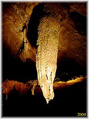
Around 350 metres (1,148.3 ft) of the Crag Cave system was developed as a show cave by local residents, Dr. Donal and Mrs Margaret Geaney, under whose land the cave was first discovered. The cave was developed between 1987 and 1989 by building a shaft (which is the only man-made entrance) and putting in pathways, railings, lights and a music system. It was opened to the public on 20th May 1989.The show cave attracts thousands of visitors every year. The tourists are given a guided tour of the cave which takes a half an hour. There are many beautiful chambers in the cave including the Cathedral and the aptly named Crystal Gallery.
A lot of features in the cave have been named after locations or characters from J.R.R. Tolkien's Middle-earth
Middle-earth
Middle-earth is the fictional setting of the majority of author J. R. R. Tolkien's fantasy writings. The Hobbit and The Lord of the Rings take place entirely in Middle-earth, as does much of The Silmarillion and Unfinished Tales....
.
The tourist centre contains a gift-shop, coffee shop and a children's play area.