
Burrinjuck Dam
Encyclopedia
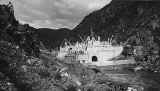
Burrinjuck Dam is a 93 metres (305.1 ft) high, concrete gravity dam on the Murrumbidgee River
approximately 60 km from Yass
, New South Wales
, Australia
. The Yass
and Goodradigbee River
s flow into the dam. The dam divides the upper and lower catchment of the Murrumbidgee and is the headwater storage for the Murrumbidgee Irrigation Area
(MIA). The dam wall is 233 m long at the crest.
accumulated hundreds of thousands of hectares in the Riverina
after owning his first property in 1864. He had an interest in water conservation
that led him to construct a series of irrigation channels and steam pumps that were critical to the rice-growing activities in the area at the turn of the century. The New South Wales government liked his ideas so much they agreed to build a larger dam.
 Construction commenced in 1907. Prior to about February 1911, the dam was known as Barren Jack, a corruption of the Aboriginal name of the locality. A narrow gauge
(610 millimetres (2 ft)) railway was constructed from the New South Wales Government Railways
' Main Southern Line
at Goondah to bring materials to the site. The railway was about 45 kilometres (28 mi) long, had a grade of 1 in 30 and some 90 foot-radius curves and took about 2 hours and 20 minutes to traverse.
Delays were experienced throughout the construction period. Problems were found in part of the foundations of the dam wall in 1911, which led to a 12-month delay in completion of the first stage of the construction works. Delays were caused by World War I
, construction of extensions to the spillways, and the fact that deep foundations were necessary.
Flooding in July 1922 filled the reservoir to the record height of 1178 feet (359.1 m) above sea level, or 198 feet (60.4 m) above the bed of the Murrumbidgee River at the dam wall. The flood waters tore through the unfinished southern spillway and fell 200 feet (61 m) to the river below, resulting in a massive fog which one journalist compared to that of Niagara Falls. The flood water came within 2 foot (0.6096 m) of spilling into the finished northern spillway, which was being used as a storage site for sand and granite used in the dam's construction. Had the water entered the northern spillway, the construction materials, worth £25,000, would have been swept away.
Another major flood
in May 1925 far exceeded all previously recorded floods and resulted in the dam wall being overtopped to a depth of 1 metre.
Due to World War I
, the dam was not completed until 1928. At the end of 1927, £1,712,730 had been spent on construction work, excluding the cost of the hydroelectric facilities.
Apparently there were real fears of the dam wall bursting, so detailed plans were prepared for the evacuation of 20,000 people in the Murrumbidgee basin downstream of the dam in the event that the dam wall failed. The State Government played down these fears and felt that the evacuation plans would never have to be used. In the event of a catastrophic failure of the dam wall, it was anticipated that flood waters would reach Jugiong
with in an hour, Gundagai
within 90 minutes, Wagga Wagga
in six hours and Narrandera
in 22 hours. Arrangements were made with police, the New South Wales Government Railways
, the postal service, military and air force officials, radio stations, boat operators and local committees to be put into effect at a moments' notice.
Remediation work was carried out between 1937 and 1957. The remediation work was authorised by the NSW Cabinet around January 1939, and at the time was anticipated to cost more than £1,000,000. The first stage of remediation works involved lowering the dam wall by 10–15 ft (3–4.6 m) and was estimated in 1937 to cost approximately £100,000.
In 1941, the State Government appointed a committee to estimate the probability of the dam flooding. This flood probability was used by consulting engineers to estimate the cost of the remediation work. The engineers estimated the remedial work would cost £1,800,000 but according to Government experts this figure was likely to be substantially exceeded.
In February 1951 a fire destroyed some of the workshops at the construction site. The compressing room, machine shop and first-aid surgery were the worst affected, and much of their contents were destroyed. The damage was estimated to cost between £50,000 and £100,000.
Eventually, the remediation work strengthened and enlarged the dam wall, increased the discharge capacity of the spillways (to about twice the peak discharge of the 1925 flood), and increased the storage capacity of the dam from about 652000 acre.ft to 837000 acre.ft.
A major flood in 1974 eroded unweathered granite from an unlined spillway discharge channel which then resulted in the destruction of a penstock
to the Burrinjuck Power Station. The outlet valves of the dam were also destroyed during the same flood. These events prompted a review of the safety of the dam which recommended a new remedial works program.
The upgrading works were completed in 1999 at a cost of A$79.5 million.
Murrumbidgee River
The Murrumbidgee River is a major river in the state of New South Wales, Australia, and the Australian Capital Territory . A major tributary of the Murray River, the Murrumbidgee flows in a west-northwesterly direction from the foot of Peppercorn Hill in the Fiery Range of the Snowy Mountains,...
approximately 60 km from Yass
Yass, New South Wales
Yass is a town in the Southern Tablelands of New South Wales, Australia in Yass Valley Shire. The name appears to have been derived from an Aboriginal word, "Yarrh" , said to mean 'running water'....
, New South Wales
New South Wales
New South Wales is a state of :Australia, located in the east of the country. It is bordered by Queensland, Victoria and South Australia to the north, south and west respectively. To the east, the state is bordered by the Tasman Sea, which forms part of the Pacific Ocean. New South Wales...
, Australia
Australia
Australia , officially the Commonwealth of Australia, is a country in the Southern Hemisphere comprising the mainland of the Australian continent, the island of Tasmania, and numerous smaller islands in the Indian and Pacific Oceans. It is the world's sixth-largest country by total area...
. The Yass
Yass River
The Yass River is a river in the state of New South Wales, Australia. The town of Yass is located on the Yass River a short distance from its confluence with the Murrumbidgee River.There are two competing theories as to the origin of the name Yass...
and Goodradigbee River
Goodradigbee River
The Goodradigbee River is in south-eastern New South Wales, Australia. It flows into Burrinjuck Dam and thus is a tributary of the Murrumbidgee River....
s flow into the dam. The dam divides the upper and lower catchment of the Murrumbidgee and is the headwater storage for the Murrumbidgee Irrigation Area
Murrumbidgee Irrigation Area
The Murrumbidgee Irrigation Area is geographically located within the Riverina area of New South Wales was created to control and divert the flow of local river and creek systems for the purpose of food production...
(MIA). The dam wall is 233 m long at the crest.
Concept
The pastoralist Samuel McCaugheySamuel McCaughey
Sir Samuel McCaughey was an Irish-born pastoralist, politician and philanthropist in Australia.-Early life:McCaughey was born at Tullyneuh, near Ballymena, Ireland, the son of Francis McCaughey, farmer and merchant, and his wife Eliza, née Wilson.McCaughey came to Australia with an uncle, Charles...
accumulated hundreds of thousands of hectares in the Riverina
Riverina
The Riverina is an agricultural region of south-western New South Wales , Australia. The Riverina is distinguished from other Australian regions by the combination of flat plains, warm to hot climate and an ample supply of water for irrigation. This combination has allowed the Riverina to develop...
after owning his first property in 1864. He had an interest in water conservation
Water conservation
Water conservation refers to reducing the usage of water and recycling of waste water for different purposes such as cleaning, manufacturing, and agricultural irrigation.- Water conservation :Water conservation can be defined as:...
that led him to construct a series of irrigation channels and steam pumps that were critical to the rice-growing activities in the area at the turn of the century. The New South Wales government liked his ideas so much they agreed to build a larger dam.
Initial construction
Narrow gauge
A narrow gauge railway is a railway that has a track gauge narrower than the of standard gauge railways. Most existing narrow gauge railways have gauges of between and .- Overview :...
(610 millimetres (2 ft)) railway was constructed from the New South Wales Government Railways
New South Wales Government Railways
The New South Wales Government Railways was the government department that operated the New South Wales Government's railways until the establishment of the Public Transport Commission in 1972. Although later known officially as the Department of Railways, New South Wales, it was still generally...
' Main Southern Line
Main Southern railway line, New South Wales
The Main Southern Railway is a major railway in New South Wales, Australia. It runs through the Southern Highlands, Southern Tablelands, South West Slopes and the Riverina regions.- Description of route :...
at Goondah to bring materials to the site. The railway was about 45 kilometres (28 mi) long, had a grade of 1 in 30 and some 90 foot-radius curves and took about 2 hours and 20 minutes to traverse.
Delays were experienced throughout the construction period. Problems were found in part of the foundations of the dam wall in 1911, which led to a 12-month delay in completion of the first stage of the construction works. Delays were caused by World War I
World War I
World War I , which was predominantly called the World War or the Great War from its occurrence until 1939, and the First World War or World War I thereafter, was a major war centred in Europe that began on 28 July 1914 and lasted until 11 November 1918...
, construction of extensions to the spillways, and the fact that deep foundations were necessary.
Flooding in July 1922 filled the reservoir to the record height of 1178 feet (359.1 m) above sea level, or 198 feet (60.4 m) above the bed of the Murrumbidgee River at the dam wall. The flood waters tore through the unfinished southern spillway and fell 200 feet (61 m) to the river below, resulting in a massive fog which one journalist compared to that of Niagara Falls. The flood water came within 2 foot (0.6096 m) of spilling into the finished northern spillway, which was being used as a storage site for sand and granite used in the dam's construction. Had the water entered the northern spillway, the construction materials, worth £25,000, would have been swept away.
Another major flood
Flood
A flood is an overflow of an expanse of water that submerges land. The EU Floods directive defines a flood as a temporary covering by water of land not normally covered by water...
in May 1925 far exceeded all previously recorded floods and resulted in the dam wall being overtopped to a depth of 1 metre.
Due to World War I
World War I
World War I , which was predominantly called the World War or the Great War from its occurrence until 1939, and the First World War or World War I thereafter, was a major war centred in Europe that began on 28 July 1914 and lasted until 11 November 1918...
, the dam was not completed until 1928. At the end of 1927, £1,712,730 had been spent on construction work, excluding the cost of the hydroelectric facilities.
Enlargement and remedial works
In 1937, it was discovered that the dam had developed a structural weakness that required remedial action. The weakness was not due to a design flaw per se; rather it was due to strains and stresses that were not scientifically understood at the time the dam was designed. The State Government brought in dam engineering expert Professor P.G. Hornell from Sweden to report on the defects that had developed in the dam.Apparently there were real fears of the dam wall bursting, so detailed plans were prepared for the evacuation of 20,000 people in the Murrumbidgee basin downstream of the dam in the event that the dam wall failed. The State Government played down these fears and felt that the evacuation plans would never have to be used. In the event of a catastrophic failure of the dam wall, it was anticipated that flood waters would reach Jugiong
Jugiong, New South Wales
Jugiong is a village community on the banks of the Murrumbidgee River, in the central east part of the Riverina. It is situated just off the Hume Highway, by road, about 30 kilometres southwest from Bookham and 40 kilometres northeast from Gundagai...
with in an hour, Gundagai
Gundagai, New South Wales
Gundagai is a town in New South Wales, Australia. Although a small town, Gundagai is a popular topic for writers and has become a representative icon of a typical Australian country town...
within 90 minutes, Wagga Wagga
Wagga Wagga, New South Wales
Wagga Wagga is a city in New South Wales, Australia. Straddling the Murrumbidgee River, and with an urban population of 46,735 people, Wagga Wagga is the state's largest inland city, as well as an important agricultural, military, and transport hub of Australia...
in six hours and Narrandera
Narrandera, New South Wales
-Transport:Narrandera is well served for transport. The Sturt Highway and the Newell Highways cross, just south of Narrandera. Greyhound buses pass daily - note that the destination can be listed as Jillenbah....
in 22 hours. Arrangements were made with police, the New South Wales Government Railways
New South Wales Government Railways
The New South Wales Government Railways was the government department that operated the New South Wales Government's railways until the establishment of the Public Transport Commission in 1972. Although later known officially as the Department of Railways, New South Wales, it was still generally...
, the postal service, military and air force officials, radio stations, boat operators and local committees to be put into effect at a moments' notice.
Remediation work was carried out between 1937 and 1957. The remediation work was authorised by the NSW Cabinet around January 1939, and at the time was anticipated to cost more than £1,000,000. The first stage of remediation works involved lowering the dam wall by 10–15 ft (3–4.6 m) and was estimated in 1937 to cost approximately £100,000.
In 1941, the State Government appointed a committee to estimate the probability of the dam flooding. This flood probability was used by consulting engineers to estimate the cost of the remediation work. The engineers estimated the remedial work would cost £1,800,000 but according to Government experts this figure was likely to be substantially exceeded.
In February 1951 a fire destroyed some of the workshops at the construction site. The compressing room, machine shop and first-aid surgery were the worst affected, and much of their contents were destroyed. The damage was estimated to cost between £50,000 and £100,000.
Eventually, the remediation work strengthened and enlarged the dam wall, increased the discharge capacity of the spillways (to about twice the peak discharge of the 1925 flood), and increased the storage capacity of the dam from about 652000 acre.ft to 837000 acre.ft.
A major flood in 1974 eroded unweathered granite from an unlined spillway discharge channel which then resulted in the destruction of a penstock
Penstock
A penstock is a sluice or gate or intake structure that controls water flow, or an enclosed pipe that delivers water to hydraulic turbines and sewerage systems. It is a term that has been inherited from the technology of wooden watermills....
to the Burrinjuck Power Station. The outlet valves of the dam were also destroyed during the same flood. These events prompted a review of the safety of the dam which recommended a new remedial works program.
Upgrade
In response to the 1974 floods, the Burrinjuck Dam Flood Security Upgrading project was undertaken to raise the existing dam wall by 12 metres (39.4 ft) to its present height of 92 metres (301.8 ft) metres and to install post-tensioned ground anchor cables to improve the security of the dam during major floods. At the time, the project was unprecedented in two respects :- the post-tensioning force required per metre length of dam crest and,
- the intensity of the flood discharge over the unlined sections of the side channel spillways during the Probable Maximum Flood (PMF).
The upgrading works were completed in 1999 at a cost of A$79.5 million.
External links
- Burrinjuck Dam Fishing Information & Map
- Richard Woodward's Dam Projects
- Burrinjuck Waters State Park
- Water levels