
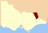
County of Benambra
Encyclopedia
Counties of Victoria
The Australian state of Victoria is divided into 37 counties. They are part of the lands administrative divisions of Australia. These counties were gazetted in stages between 1849 and 1871 as Victoria was progressively opened up to European settlement. By 1890 all parish boundaries had been gazetted...
which are part of the cadastral divisions of Australia
Cadastral divisions of Australia
Lands administrative divisions of Australia refers to the parts of Australia which are divided into the cadastral units of counties, parishes, hundreds, and other divisions for the purposes of land ownership...
, used for land titles. It is located between the Mitta Mitta River
Mitta Mitta River
The Mitta Mitta River is a major tributary of the Murray River in Australia and the source of approximately 40% of the Murray's flow.The river's headwaters include Victoria's highest mountain, Mount Bogong, with the Mitta Mitta itself forming at the confluence of the Cobungra River and the Big...
in the west, and the Murray River
Murray River
The Murray River is Australia's longest river. At in length, the Murray rises in the Australian Alps, draining the western side of Australia's highest mountains and, for most of its length, meanders across Australia's inland plains, forming the border between New South Wales and Victoria as it...
to the north and east. The town of Benambra is located near the southern edge. The area of the county roughly corresponds with the Electoral district of Benambra
Electoral district of Benambra
The Electoral district of Benambra is an electoral district of the Victorian Legislative Assembly. It is located in north-east Victoria and includes the towns of Chiltern, Wodonga, Yackandandah, Beechworth, Tallangatta, and Corryong...
. Corryong
Corryong, Victoria
Corryong is a small town in Victoria, Australia. It is located east of Albury-Wodonga, near the upper reaches of the Murray River and thus close to the New South Wales border. At the 2006 Census in Australia, Corryong had a population of 1,228....
is the largest town in the region.
Parishes
Parishes include:- Adjie, Victoria
- Beloka, Victoria
- Benambra, VictoriaBenambra, VictoriaBenambra is a small town located 28 kilometres north-east of Omeo and 430 kilometres east of the state capital Melbourne, in the Australian Alps of East Gippsland, Victoria, Australia. Other nearby towns include Swifts Creek, Ensay, and the major town of Bairnsdale...
- Berringa, VictoriaBerringa, VictoriaBerringa is a small township in west-central Victoria, Australia. It is situated in Golden Plains Shire, about 43km southwest of Ballarat.The township and surrounding rural community are located on the southern extremity of a range of Silurian slate and sandstone rock...
- Berringama, Victoria
- Bullioh, Victoria
- Bungil East, Victoria
- Bungil, Victoria
- Burrowye, Victoria
- Burrungabugge, Victoria
- Canabore, Victoria
- Cobungra, Victoria
- Colac Colac, Victoria
- Corryong, VictoriaCorryong, VictoriaCorryong is a small town in Victoria, Australia. It is located east of Albury-Wodonga, near the upper reaches of the Murray River and thus close to the New South Wales border. At the 2006 Census in Australia, Corryong had a population of 1,228....
- Cudgewa, VictoriaCudgewa, VictoriaCudgewa is a town in the Australian state of Victoria. The town is located adjacent to the Murray Valley Highway, north east of the state capital, Melbourne. Part of the Shire of Towong Local Government Area, at the 2006 census Cudgewa and the surrounding district had a population of...
- Dartella, Victoria
- Enano, Victoria
- Gibbo, Victoria
- Granya, VictoriaGranya, VictoriaGranya is a town in north eastern Victoria, Australia. The town is located on the Murray arm of Lake Hume in the Towong Shire local government area, north west of the state capital, Melbourne. At the 2006 census, Granya and the surrounding area had a population of 150.The town was established in...
- Gungarlan, Victoria
- Hinno-Munjie, Victoria
- Indi, Victoria
- Jemba, Victoria
- Jinderboine, Victoria
- Jinjellic, Victoria
- Kancobin, Victoria
- Keelangie, Victoria
- Koetong, Victoria
- Kosciusko, Victoria
- Malkara, Victoria
- Mitta Mitta, VictoriaMitta Mitta, VictoriaMitta Mitta is a small town in the Australian state of Victoria. It stands on the Omeo Highway and is 380 km from Melbourne, and is located on the Mitta Mitta River not far from Dartmouth Dam...
- Mowamba, Victoria
- Moyangul, Victoria
- Nariel, Victoria
- Pinnibar, Victoria
- Talgarno, Victoria
- Tatonga, Victoria
- Thologolong, Victoria
- Thorkidaan, Victoria
- Thowgla, Victoria
- Tintaldra, VictoriaTintaldra, VictoriaTintaldra is a town in north east Victoria, Australia. The town is located on the upper reaches of the Murray River, north east of the state capital, Melbourne and east of Wodonga...
- Towong, VictoriaTowong, VictoriaTowong is a bounded rural locality of the Shire of Towong Local Government Area in Victoria, Australia. Towong is on the Murray River close to Corryong. At the 2006 census, Towong had a population of 281.-Upper Murray Football League:...
- Wabba, Victoria
- Wagra, Victoria
- Walwa, VictoriaWalwa, VictoriaWalwa , is a town in the Shire of Towong in north east Victoria, Australia. The town is located 1 kilometre from the Murray River on the former Murray Valley highway between Wodonga and Corryong...
- Welumla, Victoria
- Wyeeboo, Victoria
- Yabba, Victoria