

Cortland, Ohio
Encyclopedia
Trumbull County, Ohio
As of the census of 2000, there were 225,116 people, 89,020 households, and 61,690 families residing in the county. The population density was 365 people per square mile . There were 95,117 housing units at an average density of 154 per square mile...
, Ohio
Ohio
Ohio is a Midwestern state in the United States. The 34th largest state by area in the U.S.,it is the 7th‑most populous with over 11.5 million residents, containing several major American cities and seven metropolitan areas with populations of 500,000 or more.The state's capital is Columbus...
, United States
United States
The United States of America is a federal constitutional republic comprising fifty states and a federal district...
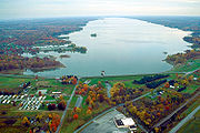
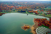
located on the eastern shore of Mosquito Creek Reservoir. Walnut Run is the creek that runs through town. The population was 6,830 at the 2000 census. It is part of the Youngstown
Youngstown, Ohio
Youngstown is a city in the U.S. state of Ohio and the county seat of Mahoning County; it also extends into Trumbull County. The municipality is situated on the Mahoning River, approximately southeast of Cleveland and northwest of Pittsburgh, Pennsylvania...
-Warren
Warren, Ohio
As of the census of 2000, there were 46,832 people, 19,288 households and 12,035 families residing in the city. The population density was 2,912.4 people per square mile . There were 21,279 housing units at an average density of 1,322.9 per square mile...
-Boardman
Boardman, Ohio
Boardman is a census-designated place in Boardman Township, Mahoning County, Ohio, United States, just south of Youngstown. Boardman is considered to be a moderately affluent community and is one of two major retail hubs in the greater Youngstown area...
, OH-PA
Pennsylvania
The Commonwealth of Pennsylvania is a U.S. state that is located in the Northeastern and Mid-Atlantic regions of the United States. The state borders Delaware and Maryland to the south, West Virginia to the southwest, Ohio to the west, New York and Ontario, Canada, to the north, and New Jersey to...
Metropolitan Statistical Area
Youngstown-Warren-Boardman, OH-PA Metropolitan Area
The Youngstown Metropolitan Area is a metropolitan area centered on the American city of Youngstown, Ohio. According to the US Census Bureau, the metropolitan area includes Mahoning and Trumbull counties in Ohio and Mercer county in Pennsylvania...
. Cortland became a village in 1874 with the construction of a railroad depot. It became a city in 1980 when its population exceeded 5,000 people.
The area was once known as Baconsburg, after Samuel Bacon, who built a sawmill and several buildings in the area during the early 19th century.
Cortland's school district is known as Lakeview. It has one elementary school, one middle school, and one high school (Lakeview High School
Lakeview High School (Ohio)
Lakeview High School in Cortland, Ohio, is the only high school in the Lakeview School District. Prior to 2004, Lakeview High School taught grades eight through 12; in 2004, the 8th grade was moved to Lakeview Middle School. Since 2009, due to financial issues and the closing of Cortland Elementary...
).
The current mayor of Cortland is Curt Moll. Past mayors include Melissa Long and Sandra Roscoe.
Famous nature/wildlife photographer, Ron Bierworth used to live there.
Demographics
As of 2000, there were 6,830 people, 2,738 households, and 1,968 families residing in the city. The population densityPopulation density
Population density is a measurement of population per unit area or unit volume. It is frequently applied to living organisms, and particularly to humans...
was 1,524.8 people per square mile (588.6/km²). There were 2,899 housing units at an average density of 647.2 per square mile (249.8/km²). The racial makeup of the city was 97.61% White, 0.94% African American, 0.12% Native American, 0.38% Asian, 0.12% from other races
Race (United States Census)
Race and ethnicity in the United States Census, as defined by the Federal Office of Management and Budget and the United States Census Bureau, are self-identification data items in which residents choose the race or races with which they most closely identify, and indicate whether or not they are...
, and 0.83% from two or more races. Hispanic or Latino of any race were 0.75% of the population.
There were 2,738 households out of which 32.6% had children under the age of 18 living with them, 59.5% were married couples
Marriage
Marriage is a social union or legal contract between people that creates kinship. It is an institution in which interpersonal relationships, usually intimate and sexual, are acknowledged in a variety of ways, depending on the culture or subculture in which it is found...
living together, 10.0% had a female householder with no husband present, and 28.1% were non-families. 24.3% of all households were made up of individuals and 10.6% had someone living alone who was 65 years of age or older. The average household size was 2.48 and the average family size was 2.97.
In the city the population was spread out with 24.6% under the age of 18, 7.4% from 18 to 24, 26.5% from 25 to 44, 27.9% from 45 to 64, and 13.5% who were 65 years of age or older. The median age was 40 years. For every 100 females there were 90.0 males. For every 100 females age 18 and over, there were 85.5 males.
The median income for a household in the city was $50,941 and the median income for a family was $62,441. Males had a median income of $50,739 versus $28,320 for females. The per capita income
Per capita income
Per capita income or income per person is a measure of mean income within an economic aggregate, such as a country or city. It is calculated by taking a measure of all sources of income in the aggregate and dividing it by the total population...
for the city was $22,972. About 4.6% of families and 5.3% of the population were below the poverty line, including 6.3% of those under age 18 and 3.0% of those age 65 or over.