

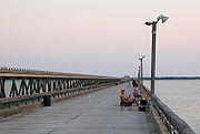
Copano Bay Fishing Pier
Encyclopedia
Pier
A pier is a raised structure, including bridge and building supports and walkways, over water, typically supported by widely spread piles or pillars...
in Aransas County, Texas
Aransas County, Texas
Aransas County is a county located in the U.S. state of Texas. It is part of the Corpus Christi Metropolitan Statistical Area. As of 2000, the population was 22,499. Its county seat is Rockport. Aransas County was formed in 1871 from Refugio County.-Geography:According to the U.S...
, United States
United States
The United States of America is a federal constitutional republic comprising fifty states and a federal district...
used primarily for recreation
Recreation
Recreation is an activity of leisure, leisure being discretionary time. The "need to do something for recreation" is an essential element of human biology and psychology. Recreational activities are often done for enjoyment, amusement, or pleasure and are considered to be "fun"...
al fishing
Fishing
Fishing is the activity of trying to catch wild fish. Fish are normally caught in the wild. Techniques for catching fish include hand gathering, spearing, netting, angling and trapping....
. The pier has two separate sections. One is 2500 feet long on the south side of the bay and the other is 6190 feet, or 1,886.712 meters, long on the north side.
The pier was originally the causeway
Causeway
In modern usage, a causeway is a road or railway elevated, usually across a broad body of water or wetland.- Etymology :When first used, the word appeared in a form such as “causey way” making clear its derivation from the earlier form “causey”. This word seems to have come from the same source by...
across Copano Bay
Copano Bay
Copano Bay is a northwestern extension of Aransas Bay, west of Rockport, Texas in Refugio and Aransas counties. It is supplied with seawater from the Gulf of Mexico via Aransas Bay, and fed freshwater from the Aransas River, Mission River and Copano Creek...
for State Highway 35. In 1967, a new causeway opened and the old one was closed to vehicular traffic. The new causeway had a higher middle section then the old one, so the old middle section was removed to allow for passage of larger ships. This left the two piers.
The State Department of Highways and Public Transportation (Now part of the Texas Department of Transportation
Texas Department of Transportation
The Texas Department of Transportation is a governmental agency in the U.S. state of Texas. Its stated mission is to "work cooperatively to provide safe, effective and efficient movement of people and goods" throughout the state...
) transferred ownership of the pier to the Texas Parks and Wildlife Department
Texas Parks and Wildlife Department
The Texas Parks & Wildlife Department is a Texas state agency that oversees and protects wildlife and their habitats. In addition, the agency is responsible for managing the state's parks and historical areas...
(TPWD) and the pier became a 5.9 acres (23,876.5 m²) state park
State park
State parks are parks or other protected areas managed at the federated state level within those nations which use "state" as a political subdivision. State parks are typically established by a state to preserve a location on account of its natural beauty, historic interest, or recreational...
. On November 1, 2005 TPWD transferred control of the pier to the Aransas County Navigation District No.1 (ACND).