
Connecticut Route 97
Encyclopedia
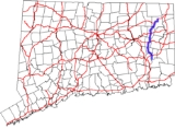
Route 97 is a north–south state highway
in eastern Connecticut
running for 29.14 miles (46.9 km) from Route 12 in Norwich
to US 44
in Pomfret
.
, briefly overlapping with Route 169 before passing through Sprague
into Scotland
, where it overlaps Route 14 for 0.68 miles (1.1 km). After the overlap, it continues north and northeast through Hampton
into Pomfret, where it ends at its northern of two intersections with US 44, also meeting Route 169.
, Highway 345 renumbered to Route 201, while most of Highway 354 (between Baltic and Lebanon center) became Route 207. Most of modern Route 97 was commissioned in 1932 as well, including the Taftville-Baltic portion of old Highway 354. The original Route 97 deviated from the current route at Station Road in Hampton and ran north to Route 91 (now Route 198
) in Chaplin
. It was relocated to its current route between Hampton and Abington using a previously unsigned state road (former SR 860) in 1934. At the same time, Route 97 absorbed former Route 201, extendng the route to Pomfret Center.
State highway
State highway, state road or state route can refer to one of three related concepts, two of them related to a state or provincial government in a country that is divided into states or provinces :#A...
in eastern Connecticut
Connecticut
Connecticut is a state in the New England region of the northeastern United States. It is bordered by Rhode Island to the east, Massachusetts to the north, and the state of New York to the west and the south .Connecticut is named for the Connecticut River, the major U.S. river that approximately...
running for 29.14 miles (46.9 km) from Route 12 in Norwich
Norwich, Connecticut
Regular steamship service between New York and Boston helped Norwich to prosper as a shipping center through the early part of the 20th century. During the Civil War, Norwich once again rallied and saw the growth of its textile, armaments, and specialty item manufacturing...
to US 44
U.S. Route 44
U.S. Route 44 is an east–west United States highway that runs for 237 miles through four states in the Northeastern region of the United States. The western terminus is at U.S. Route 209 and New York State Route 55 in Kerhonkson, a hamlet in the Hudson Valley region of New York...
in Pomfret
Pomfret, Connecticut
Pomfret is a town in Windham County, Connecticut, United States. The population was 3,798 at the 2000 census.-Geography:According to the United States Census Bureau, the town has a total area of , of which, of it is land and of it is water....
.
Route description
Route 97 begins at an intersection with Route 12 in the Taftville section of Norwich, then heads north along the Shetucket RiverShetucket River
The Shetucket River is a tributary of the Thames River, long, in eastern Connecticut in the United States.It is formed at Willimantic by the junction of the Willimantic and Natchaug rivers. It flows southeast and south...
, briefly overlapping with Route 169 before passing through Sprague
Sprague, Connecticut
Sprague is a town in New London County, Connecticut, United States. The town was named after William Sprague, who laid out the industrial section. The population was 2,971 at the 2000 census...
into Scotland
Scotland, Connecticut
Scotland is a town in Windham County, Connecticut, in the United States. As of the 2000 census, the town population was 1,556. Scotland is a predominantly rural town, with agriculture as the principal industry.-Geography:...
, where it overlaps Route 14 for 0.68 miles (1.1 km). After the overlap, it continues north and northeast through Hampton
Hampton, Connecticut
Hampton is a town in Windham County, Connecticut, United States. The population was 1,758 at the 2000 census.-Geography:According to the United States Census Bureau, the town has a total area of , of which, of it is land and of it is water....
into Pomfret, where it ends at its northern of two intersections with US 44, also meeting Route 169.
Special Designations
Route 97 is designated a scenic route from its southern intersection with US 44 in Pomfret to its northern terminus, a distance of 4.5 miles (7.2 km).History
In 1922, the road from Abington to Pomfret Center along modern Route 97 was designated as State Highway 345. Further south, the road from Taftville to Baltic was part of State Highway 354, which continued past Baltic to Lebanon center. In the 1932 state highway renumbering1932 state highway renumbering (Connecticut)
In 1932, the Highway Department of the U.S. state of Connecticut , decided to completely renumber all its state highways. The only exceptions were the U.S. Highways and some of the New England Interstate Routes. Between 1922 and 1932, Connecticut used a state highway numbering system shared with...
, Highway 345 renumbered to Route 201, while most of Highway 354 (between Baltic and Lebanon center) became Route 207. Most of modern Route 97 was commissioned in 1932 as well, including the Taftville-Baltic portion of old Highway 354. The original Route 97 deviated from the current route at Station Road in Hampton and ran north to Route 91 (now Route 198
Connecticut Route 198
Route 198 is a state highway in northeastern Connecticut, running from Chaplin to the Massachusetts state line in Woodstock.-Route description:...
) in Chaplin
Chaplin, Connecticut
Chaplin is a town in Windham County, Connecticut, United States. The town was named for Deacon Benjamin Chaplin, an early settler. The population was 2,305 at the 2010 census.-Points of interest:* The Chaplin Museum is a local historical museum....
. It was relocated to its current route between Hampton and Abington using a previously unsigned state road (former SR 860) in 1934. At the same time, Route 97 absorbed former Route 201, extendng the route to Pomfret Center.
Junction list
| Town | Road names | Major junctions | Milepost | Notes |
|---|---|---|---|---|
| Norwich Norwich, Connecticut Regular steamship service between New York and Boston helped Norwich to prosper as a shipping center through the early part of the 20th century. During the Civil War, Norwich once again rallied and saw the growth of its textile, armaments, and specialty item manufacturing... (4.22 miles) |
Norwich Avenue, Taftville Occum Road, Bridge Street, Baltic Road |
0.00 | ||
| 0.68-0.70 | Begin Multiplex | |||
| 0.98-0.99 | End Multiplex | |||
| 2.19-2.21 | I-395 Exit 83 | |||
| Sprague Sprague, Connecticut Sprague is a town in New London County, Connecticut, United States. The town was named after William Sprague, who laid out the industrial section. The population was 2,971 at the 2000 census... (4.05 miles) |
Main Street, Scotland Road | 5.38 | ||
| 5.54 | ||||
| Scotland Scotland, Connecticut Scotland is a town in Windham County, Connecticut, in the United States. As of the 2000 census, the town population was 1,556. Scotland is a predominantly rural town, with agriculture as the principal industry.-Geography:... (6.09 miles) |
Devotion Road, Pudding Hill Road | 11.26 | Begin Multiplex | |
| 11.94 | End Multiplex | |||
| Hampton Hampton, Connecticut Hampton is a town in Windham County, Connecticut, United States. The population was 1,758 at the 2000 census.-Geography:According to the United States Census Bureau, the town has a total area of , of which, of it is land and of it is water.... (7.90 miles) |
Pudding Hill Road, Main Street, Pomfret Road | 16.80 | ||
| Pomfret Pomfret, Connecticut Pomfret is a town in Windham County, Connecticut, United States. The population was 3,798 at the 2000 census.-Geography:According to the United States Census Bureau, the town has a total area of , of which, of it is land and of it is water.... (6.88 miles) |
Hampton Road, Deerfield Road | 24.69 | ||
| 28.41 | ||||
| 29.14 |