
Connecticut Route 136
Encyclopedia
Route 136 is a state highway in southwestern Connecticut
, running from Darien
to Easton
. The route was initially established in 1932 to serve the beach communities between Darien and Southport
. Its eastern end was relocated in 1963 to head northeast from Westport
to Easton
instead.
in Darien and heads east, intersecting I-95 before crossing into Norwalk
. In Norwalk, it continues south, east, and northeast through the Rowayton section of the city before a 1.11 miles (2 km) section maintained by the city between the intersection of Wilson and Meadow Streets and the intersection of Water and Washington Street, after which it continues east across the Norwalk River
, through a triangular one-way couplet and into Westport
. In Westport, Route 136 turns northeast along the Saugatuck River
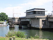
, intersecting I-95 again before crossing the Saugatuck (via the Saugatuck River Bridge
), briefly overlapping Route 57, passing beneath Route 15 without a junction, and continuing northeast across the northwest corner of Fairfield
into Easton. In Easton, it continues northeast before ending at an intersection with Route 59
.
known as the Branch Turnpike, which was incorporated in 1831. The road ran from Wesport center, through Easton center and the Upper Stepney section of Monroe
, to the Housatonic River
at Bennett's Bridge in Newtown
, and collected tolls until 1851. Between Easton center and Upper Stepney, the old turnpike is now part of Route 59.
In the early 1920s, Connecticut assigned numbers to its state roads. A coastal road in the Gold Coast
region of the state running parallel to U.S. Route 1
, from Darien
to Southport, was designated as State Highway 335. The former Branch Turnpike, however, remained unnumbered. Route 136 was formed as part of the 1932 state highway renumbering
as a renumbering of old Highway 335. In 1963, Route 136 was relocated to its current route, including the portion along the old Branch Turnpike, as a result of the 1961 Route Reclassification Act. Maintenance of the coastal portion of old Route 136 in Westport and Fairfield was returned to the towns. Additionally, a 1.1 miles (1.8 km) section in the South Norwalk section of Norwalk
is still maintained by the city and is one of only two such maintenance gaps in a state highway in Connecticut (the other gap is at Route 83
).
Connecticut
Connecticut is a state in the New England region of the northeastern United States. It is bordered by Rhode Island to the east, Massachusetts to the north, and the state of New York to the west and the south .Connecticut is named for the Connecticut River, the major U.S. river that approximately...
, running from Darien
Darien, Connecticut
Darien is a town in Fairfield County, Connecticut, United States. A relatively small community on Connecticut's "Gold Coast", the population was 20,732 at the 2010 census. Darien was listed at #9 at CNN Money's list of "top-earning towns" in the United States as of 2011...
to Easton
Easton, Connecticut
Easton is a town in Fairfield County, Connecticut, United States. The population was 7,490 at the 2010 census. Easton contains the historic district of Aspetuck....
. The route was initially established in 1932 to serve the beach communities between Darien and Southport
Southport, Connecticut
Southport is a section and census-designated place of the town of Fairfield, Connecticut, located along Long Island Sound between the Mill River and Sasco Brook . As of the 2010 census it had a population of 1,585...
. Its eastern end was relocated in 1963 to head northeast from Westport
Westport, Connecticut
-Neighborhoods:* Saugatuck – around the Westport railroad station near the southwestern corner of the town – a built-up area with some restaurants, stores and offices....
to Easton
Easton, Connecticut
Easton is a town in Fairfield County, Connecticut, United States. The population was 7,490 at the 2010 census. Easton contains the historic district of Aspetuck....
instead.
Route description
Route 136 begins at an intersection with US 1U.S. Route 1 in Connecticut
In the U.S. state of Connecticut, U.S. Route 1 is a major east–west state highway along Long Island Sound. It has been replaced by Interstate 95 as a through route, which it closely parallels, and now primarily serves as a local business route...
in Darien and heads east, intersecting I-95 before crossing into Norwalk
Norwalk, Connecticut
Norwalk is a city in Fairfield County, Connecticut, United States. According to the 2010 U.S. Census, the population of the city is 85,603, making Norwalk sixth in population in Connecticut, and third in Fairfield County...
. In Norwalk, it continues south, east, and northeast through the Rowayton section of the city before a 1.11 miles (2 km) section maintained by the city between the intersection of Wilson and Meadow Streets and the intersection of Water and Washington Street, after which it continues east across the Norwalk River
Norwalk River
The Norwalk River is a river in southwestern Connecticut, approximately long. The word "Norwalk" comes from the Algonquian word "noyank" meaning "point of land".-Description:...
, through a triangular one-way couplet and into Westport
Westport, Connecticut
-Neighborhoods:* Saugatuck – around the Westport railroad station near the southwestern corner of the town – a built-up area with some restaurants, stores and offices....
. In Westport, Route 136 turns northeast along the Saugatuck River
Saugatuck River
The Saugatuck River is a river in southwestern Connecticut in the United States. It drains part of suburban and rural Fairfield County west of Bridgeport, emptying into Long Island Sound.-Description:...
, intersecting I-95 again before crossing the Saugatuck (via the Saugatuck River Bridge
Saugatuck River Bridge
The Saugatuck River Bridge is a bridge in Connecticut carrying Route 136 over the Saugatuck River in Westport. The bridge, built in 1884, is the oldest surviving movable bridge in Connecticut and is listed on the National Register of Historic Places. The total length of the bridge is with a deck...
), briefly overlapping Route 57, passing beneath Route 15 without a junction, and continuing northeast across the northwest corner of Fairfield
Fairfield, Connecticut
Fairfield is a town located in Fairfield County, Connecticut, United States. It is bordered by the towns of Bridgeport, Trumbull, Easton, Redding and Westport along the Gold Coast of Connecticut. As of the 2010 census, the town had a population of 59,404...
into Easton. In Easton, it continues northeast before ending at an intersection with Route 59
Connecticut Route 59
Route 59 is a north–south state highway in Connecticut, running from Bridgeport to Monroe. Between Bridgeport and Easton, Route 59 used to be the Stratfield and Weston Turnpike, which operated from 1797 to 1886...
.
History
Modern Route 136 in Westport and Easton was the southern portion of an early 19th-century private turnpikeToll road
A toll road is a privately or publicly built road for which a driver pays a toll for use. Structures for which tolls are charged include toll bridges and toll tunnels. Non-toll roads are financed using other sources of revenue, most typically fuel tax or general tax funds...
known as the Branch Turnpike, which was incorporated in 1831. The road ran from Wesport center, through Easton center and the Upper Stepney section of Monroe
Monroe, Connecticut
Monroe is a town in Fairfield County, Connecticut, United States. The population was 19,479 at the 2010 census. The current first selectman is Steve Vavrek....
, to the Housatonic River
Housatonic River
The Housatonic River is a river, approximately long, in western Massachusetts and western Connecticut in the United States. It flows south to southeast, and drains about of southwestern New England into Long Island Sound...
at Bennett's Bridge in Newtown
Newtown, Connecticut
Newtown is a town in Fairfield County, Connecticut, United States. The population was 27,560 at the 2010 census. Newtown was founded in 1705 and incorporated in 1711.-Government:...
, and collected tolls until 1851. Between Easton center and Upper Stepney, the old turnpike is now part of Route 59.
In the early 1920s, Connecticut assigned numbers to its state roads. A coastal road in the Gold Coast
Gold Coast (Connecticut)
The Gold Coast, also known as Southwestern Connecticut or Lower Fairfield County, is a region of the state of Connecticut, United States, that includes the entire southern portion of Fairfield County as defined by the U.S. Census Bureau, Super-Public Use Microdata Area Region 09600.This area is...
region of the state running parallel to U.S. Route 1
U.S. Route 1 in Connecticut
In the U.S. state of Connecticut, U.S. Route 1 is a major east–west state highway along Long Island Sound. It has been replaced by Interstate 95 as a through route, which it closely parallels, and now primarily serves as a local business route...
, from Darien
Darien, Connecticut
Darien is a town in Fairfield County, Connecticut, United States. A relatively small community on Connecticut's "Gold Coast", the population was 20,732 at the 2010 census. Darien was listed at #9 at CNN Money's list of "top-earning towns" in the United States as of 2011...
to Southport, was designated as State Highway 335. The former Branch Turnpike, however, remained unnumbered. Route 136 was formed as part of the 1932 state highway renumbering
1932 state highway renumbering (Connecticut)
In 1932, the Highway Department of the U.S. state of Connecticut , decided to completely renumber all its state highways. The only exceptions were the U.S. Highways and some of the New England Interstate Routes. Between 1922 and 1932, Connecticut used a state highway numbering system shared with...
as a renumbering of old Highway 335. In 1963, Route 136 was relocated to its current route, including the portion along the old Branch Turnpike, as a result of the 1961 Route Reclassification Act. Maintenance of the coastal portion of old Route 136 in Westport and Fairfield was returned to the towns. Additionally, a 1.1 miles (1.8 km) section in the South Norwalk section of Norwalk
Norwalk, Connecticut
Norwalk is a city in Fairfield County, Connecticut, United States. According to the 2010 U.S. Census, the population of the city is 85,603, making Norwalk sixth in population in Connecticut, and third in Fairfield County...
is still maintained by the city and is one of only two such maintenance gaps in a state highway in Connecticut (the other gap is at Route 83
Route 83 (Connecticut)
Route 83 is a north–south state highway in the Greater Hartford and Greater Springfield areas of the U.S. states of Connecticut and Massachusetts. It serves as the main north–south artery for the towns of Manchester, Vernon, and Ellington and continues through East Longmeadow center...
).
Junction list
| Town | Road names | Junction | Milepost |
|---|---|---|---|
| Darien Darien, Connecticut Darien is a town in Fairfield County, Connecticut, United States. A relatively small community on Connecticut's "Gold Coast", the population was 20,732 at the 2010 census. Darien was listed at #9 at CNN Money's list of "top-earning towns" in the United States as of 2011... (1.26 miles (2.03 km)) |
Tokeneke Road | 0.00 | |
| 0.29 | |||
| Norwalk Norwalk, Connecticut Norwalk is a city in Fairfield County, Connecticut, United States. According to the 2010 U.S. Census, the population of the city is 85,603, making Norwalk sixth in population in Connecticut, and third in Fairfield County... (5.99 miles (9.64 km)) |
Cudlipp Avenue, Rowayton Avenue, McKinley Street, Highland Avenue, Wilson Avenue, Meadow Street, Woodward Avenue, Burritt Avenue, Water Street, Washington Street, Fort Point Street, Van Zant Street, East Avenue, Cemetery Street, Gregory Boulevard, Winfield Street | (Begin city maintenance) | 4.14 |
| (End city maintenance) | 5.25 | ||
| Westport Westport, Connecticut -Neighborhoods:* Saugatuck – around the Westport railroad station near the southwestern corner of the town – a built-up area with some restaurants, stores and offices.... (7.26 miles (11.68 km)) |
Saugatuck Ave., Park St., Charles St., Riverside Ave., Bridge St., S. Compo Rd., N. Compo Rd., Main St., Easton Rd. |
8.28 | |
| 10.49 | |||
| 11.78-12.08 | |||
| Fairfield Fairfield, Connecticut Fairfield is a town located in Fairfield County, Connecticut, United States. It is bordered by the towns of Bridgeport, Trumbull, Easton, Redding and Westport along the Gold Coast of Connecticut. As of the 2010 census, the town had a population of 59,404... (0.17 mile (0.2735878 km)) |
Westport Turnpike | (No major junctions) | |
| Easton Easton, Connecticut Easton is a town in Fairfield County, Connecticut, United States. The population was 7,490 at the 2010 census. Easton contains the historic district of Aspetuck.... (4.41 miles (7.1 km)) |
Westport Road | 17.25 | |
| 20.46 |