Conecuh River
Encyclopedia
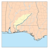
The Conecuh River and Escambia River constitute a single 258 miles (415.2 km) river in Alabama
and Florida
in the United States
.
The Conecuh River rises near Union Springs
in the state and flows 198 miles (318.6 km) in a general southwesterly direction into Florida
near Century
. The river's name changes from the Conecuh to the Escambia at the junction of Escambia Creek, 1.2 miles (1.9 km) downstream from the Florida
-Alabama line. After this point, the Escambia River flows 60 miles (96.6 km) south to Escambia Bay
, an arm of Pensacola Bay
.
The river is dredged in the lower course.
Alabama
Alabama is a state located in the southeastern region of the United States. It is bordered by Tennessee to the north, Georgia to the east, Florida and the Gulf of Mexico to the south, and Mississippi to the west. Alabama ranks 30th in total land area and ranks second in the size of its inland...
and Florida
Florida
Florida is a state in the southeastern United States, located on the nation's Atlantic and Gulf coasts. It is bordered to the west by the Gulf of Mexico, to the north by Alabama and Georgia and to the east by the Atlantic Ocean. With a population of 18,801,310 as measured by the 2010 census, it...
in the United States
United States
The United States of America is a federal constitutional republic comprising fifty states and a federal district...
.
The Conecuh River rises near Union Springs
Union Springs, Alabama
Union Springs is a town in Bullock County, Alabama, United States. The population was 3,670 at the 2000 census.-History:The area that became Union Springs was first settled by white men after the Creek Indian removal of the 1830s. Twenty-seven springs watered the land, giving rise to the name of...
in the state and flows 198 miles (318.6 km) in a general southwesterly direction into Florida
Florida
Florida is a state in the southeastern United States, located on the nation's Atlantic and Gulf coasts. It is bordered to the west by the Gulf of Mexico, to the north by Alabama and Georgia and to the east by the Atlantic Ocean. With a population of 18,801,310 as measured by the 2010 census, it...
near Century
Century, Florida
Century is a town in Escambia County, Florida, United States. The population was 1,714 at the 2000 census. It is part of the Pensacola–Ferry Pass–Brent Metropolitan Statistical Area.-Geography:Century is located at ....
. The river's name changes from the Conecuh to the Escambia at the junction of Escambia Creek, 1.2 miles (1.9 km) downstream from the Florida
Florida
Florida is a state in the southeastern United States, located on the nation's Atlantic and Gulf coasts. It is bordered to the west by the Gulf of Mexico, to the north by Alabama and Georgia and to the east by the Atlantic Ocean. With a population of 18,801,310 as measured by the 2010 census, it...
-Alabama line. After this point, the Escambia River flows 60 miles (96.6 km) south to Escambia Bay
Escambia Bay
Escambia Bay is a bay located mostly in Santa Rosa County and partly in Escambia County, Florida, in the far western Florida Panhandle. The city of Pensacola is located on the western side, and the town of Milton is located on the northeastern end of the two-pronged bay. Both places are the...
, an arm of Pensacola Bay
Pensacola Bay
Pensacola Bay is a bay located in the northwestern part of Florida, United States, known as the Florida Panhandle.The bay, an inlet of the Gulf of Mexico, is located in Escambia County and Santa Rosa County, adjacent to the city of Pensacola, Florida, and is about 13 miles long and 2.5 miles ...
.
The river is dredged in the lower course.

