
Conargo, New South Wales
Encyclopedia
Conargo is a small rural town located in the Riverina
region of New South Wales
, Australia
and is the seat of Conargo Shire
. It is situated on the Billabong Creek
, a tributary
of the Murrumbidgee River
. The nearest towns are Jerilderie
and Deniliquin. At the 2006 census
, Conargo had a population of 188 people.
The Aboriginal name for the locality of Conargo was 'Gooriara', meaning "hopping" or "kangaroo ground".
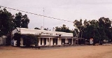
The actual town itself is quite small, with only a pub, a convenience store
that sells fuel and a small number of houses, however the Shire now covers an area of approximately 8830 square kilometres and has a population of 1806. There are five nearby villages - Blighty
, Mayrung
, Pretty Pine
, Wanganella
and Booroorban
.
The surrounding rural area consists of large sheep stations
, including some Merino
stud
s.
In February 1878 a correspondent to the Town and Country Journal said: "Conargo... was once - according to tradition - intended to be a town, which attempt finally diminished to a total failure". The writer added that the proprietor of the only store in the village had recently died after "a long and continued illness". Of the three hotels it was claimed the Conargo Hotel was the "better house", doing "a great deal more business than the other two combined".
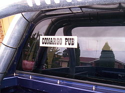 Conargo is famous amongst people who attend Ute Muster
s (who are known locally as Friggers) because of the humour in visiting a pub in such a remote location.
Ute enthusiasts often decorate their vehicles with bumper stickers, and to cash in on this market the Conargo Pub as it is known, offers stickers that read "CONARGO PUB" in black writing on a white backdrop. Since, Conargo's town is neighbouring Deniliquin which hosts the worlds largest Ute Muster, the popularity of the Conargo pub sticker has spread amongst the ute community and adorning their vehicle with one has developed into a status symbol among ute enthusiasts .
Riverina
The Riverina is an agricultural region of south-western New South Wales , Australia. The Riverina is distinguished from other Australian regions by the combination of flat plains, warm to hot climate and an ample supply of water for irrigation. This combination has allowed the Riverina to develop...
region of New South Wales
New South Wales
New South Wales is a state of :Australia, located in the east of the country. It is bordered by Queensland, Victoria and South Australia to the north, south and west respectively. To the east, the state is bordered by the Tasman Sea, which forms part of the Pacific Ocean. New South Wales...
, Australia
Australia
Australia , officially the Commonwealth of Australia, is a country in the Southern Hemisphere comprising the mainland of the Australian continent, the island of Tasmania, and numerous smaller islands in the Indian and Pacific Oceans. It is the world's sixth-largest country by total area...
and is the seat of Conargo Shire
Conargo Shire Council
Conargo Shire Council is a local government area in New South Wales, Australia. It is the smallest Local Government Area in New South Wales. Conargo Shire was established in 1907. In 2001 the former Windouran shire was absorbed into Conargo Shire. This amalgamation resulted in an additional...
. It is situated on the Billabong Creek
Billabong Creek
Billabong Creek is a creek in the Riverina region in New South Wales, Australia. The creek is part of the Murray-Darling River system. It is held to be the longest creek in New South Wales....
, a tributary
Tributary
A tributary or affluent is a stream or river that flows into a main stem river or a lake. A tributary does not flow directly into a sea or ocean...
of the Murrumbidgee River
Murrumbidgee River
The Murrumbidgee River is a major river in the state of New South Wales, Australia, and the Australian Capital Territory . A major tributary of the Murray River, the Murrumbidgee flows in a west-northwesterly direction from the foot of Peppercorn Hill in the Fiery Range of the Snowy Mountains,...
. The nearest towns are Jerilderie
Jerilderie, New South Wales
Jerilderie is a town of 768 people in the southern Riverina region of New South Wales, Australia. It is the only town in the Jerilderie Shire Local Government Area....
and Deniliquin. At the 2006 census
Census in Australia
The Australian census is administered once every five years by the Australian Bureau of Statistics. The most recent census was conducted on 9 August 2011; the next will be conducted in 2016. Prior to the introduction of regular censuses in 1961, they had also been run in 1901, 1911, 1921, 1933,...
, Conargo had a population of 188 people.
The Aboriginal name for the locality of Conargo was 'Gooriara', meaning "hopping" or "kangaroo ground".
The actual town itself is quite small, with only a pub, a convenience store
Convenience store
A convenience store, corner store, corner shop, commonly called a bodega in Spanish-speaking areas of the United States, is a small store or shop in a built up area that stocks a range of everyday items such as groceries, toiletries, alcoholic and soft drinks, and may also offer money order and...
that sells fuel and a small number of houses, however the Shire now covers an area of approximately 8830 square kilometres and has a population of 1806. There are five nearby villages - Blighty
Blighty, New South Wales
Blighty is a small town in the Riverina region of New South Wales, Australia. The town lies on the Riverina Highway between the towns of Finley and Deniliquin. It is located in the Conargo Shire Council Local Government Area. At the 2006 census, Blighty and the surrounding area had a population...
, Mayrung
Mayrung, New South Wales
Mayrung is a community in the central part of the Riverina and situated about 55 kilometres east from Pretty Pine and 40 kilometres north east from Deniliquin....
, Pretty Pine
Pretty Pine, New South Wales
Pretty Pine is a community in the central part of the Riverina and situated about 17 kilometres south from Wanganella and 18 kilometres north west from Deniliquin....
, Wanganella
Wanganella, New South Wales
Wanganella is a village community on the Billabong Creek in New South Wales, Australia. The settlement is on the Cobb Highway, located between Hay and Deniliquin . Wanganella is within the Conargo Shire Council local government area...
and Booroorban
Booroorban, New South Wales
Booroorban is a locality in the central part of the Riverina and is situated about 47 kilometres south of Hay and 55 kilometres north from Pretty Pine. The community sits alongside the Booroorban State Forest. ...
.
The surrounding rural area consists of large sheep stations
Sheep station
A sheep station is a large property in Australia or New Zealand whose main activity is the raising of sheep for their wool and meat. In Australia, sheep stations are usually in the south-east or south-west of the country. In New Zealand the Merinos are usually in the high country of the South...
, including some Merino
Merino
The Merino is an economically influential breed of sheep prized for its wool. Merinos are regarded as having some of the finest and softest wool of any sheep...
stud
Stud farm
A stud farm or stud in animal husbandry, is an establishment for selective breeding of livestock. The word "stud" comes from the Old English stod meaning "herd of horses, place where horses are kept for breeding" Historically, documentation of the breedings that occur on a stud farm leads to the...
s.
History
In 1859 William McKenzie opened the Conargo Inn there (named after the nearby "Conargo" pastoral run). A township at Conargo was laid out in 1860 by the surveyor McCulloch. During 1865 another hotel was built at the village - the Riverine Hotel (publican James McKeys). At about the same time the Conargo Inn, together with 320 acres (1.3 km²), was sold for £1,857 to T. Robertson. Conargo Post Office opened on 1 September 1864 and closed in 1988. In 1866 Conargo was reported as having a population of thirty persons, with a post-office, a store, and two hotels. In 1867 the Billabong Hotel was added to Conargo's hotels (with David Rogers as its first publican). In 1869 the Baker brothers built a store there. In 1872 Conargo was described as a small village with a store and three hotels.In February 1878 a correspondent to the Town and Country Journal said: "Conargo... was once - according to tradition - intended to be a town, which attempt finally diminished to a total failure". The writer added that the proprietor of the only store in the village had recently died after "a long and continued illness". Of the three hotels it was claimed the Conargo Hotel was the "better house", doing "a great deal more business than the other two combined".
Conargo Pub
Ute muster
A ute muster is an Australian festival which brings together large numbers of utes and ute enthusiasts. These events typically include competitions and other side events, occur annually, and normally last several days...
s (who are known locally as Friggers) because of the humour in visiting a pub in such a remote location.
Ute enthusiasts often decorate their vehicles with bumper stickers, and to cash in on this market the Conargo Pub as it is known, offers stickers that read "CONARGO PUB" in black writing on a white backdrop. Since, Conargo's town is neighbouring Deniliquin which hosts the worlds largest Ute Muster, the popularity of the Conargo pub sticker has spread amongst the ute community and adorning their vehicle with one has developed into a status symbol among ute enthusiasts .