

Columbia Icefield
Encyclopedia
Canadian Rockies
The Canadian Rockies comprise the Canadian segment of the North American Rocky Mountains range. They are the eastern part of the Canadian Cordillera, extending from the Interior Plains of Alberta to the Rocky Mountain Trench of British Columbia. The southern end borders Idaho and Montana of the USA...
, astride the Continental Divide
Continental Divide
The Continental Divide of the Americas, or merely the Continental Gulf of Division or Great Divide, is the name given to the principal, and largely mountainous, hydrological divide of the Americas that separates the watersheds that drain into the Pacific Ocean from those river systems that drain...
of North America
North America
North America is a continent wholly within the Northern Hemisphere and almost wholly within the Western Hemisphere. It is also considered a northern subcontinent of the Americas...
. The icefield lies partly in the northwestern tip of Banff National Park
Banff National Park
Banff National Park is Canada's oldest national park, established in 1885 in the Rocky Mountains. The park, located 110–180 kilometres west of Calgary in the province of Alberta, encompasses of mountainous terrain, with numerous glaciers and ice fields, dense coniferous forest, and alpine...
and the southern end of Jasper National Park
Jasper National Park
Jasper National Park is the largest national park in the Canadian Rockies, spanning 10,878 km² . It is located in the province of Alberta, north of Banff National Park and west of the City of Edmonton. The park includes the glaciers of the Columbia Icefield, hot springs, lakes, waterfalls and...
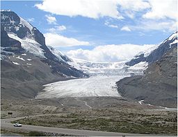
. It is about 325 km² in area, 100 to 365 metres (328 to 1,197 ft) in depth and receives up to seven metres (275 in) of snowfall per year. The icefield feeds eight major glacier
Glacier
A glacier is a large persistent body of ice that forms where the accumulation of snow exceeds its ablation over many years, often centuries. At least 0.1 km² in area and 50 m thick, but often much larger, a glacier slowly deforms and flows due to stresses induced by its weight...
s, including:
- Athabasca GlacierAthabasca GlacierThe Athabasca Glacier is one of the six principal 'toes' of the Columbia Icefield, located in the Canadian Rockies. The glacier currently recedes at a rate of per year and has receded more than in the past 125 years and lost over half of its volume...
- Castleguard Glacier
- Columbia Glacier
- Dome Glacier
- Stutfield Glacier
- Saskatchewan GlacierSaskatchewan GlacierSaskatchewan Glacier is located in Banff National Park, Alberta, Canada, approximately northwest of the town of Banff, and can be accessed from the Icefields Parkway. Saskatchewan Glacier is the largest outflow glacier from the Columbia Icefield, which rests along the Continental divide. The...
Some of the highest mountain
Mountain
Image:Himalaya_annotated.jpg|thumb|right|The Himalayan mountain range with Mount Everestrect 58 14 160 49 Chomo Lonzorect 200 28 335 52 Makalurect 378 24 566 45 Mount Everestrect 188 581 920 656 Tibetan Plateaurect 250 406 340 427 Rong River...
s in the Canada Rockies are located around the edges:
- Mount AndromedaMount Andromeda (Alberta)Mount Andromeda is located within the Columbia Icefield on the boundary of Banff and Jasper national parks. The mountain can be seen from the Icefields Parkway near Sunwapta Pass and is directly southwest of Mount Athabasca.Mt...
(3,450 m) - Mount AthabascaMount AthabascaMount Athabasca is located in the Columbia Icefield of Jasper National Park in Canada. The mountain was named in 1898 by J. Norman Collie, who made the first ascent on August 18 of that year...
(3,491 m) - Mount BryceMount BryceMount Bryce is a mountain at the southwestern corner of the Columbia Icefield, in British Columbia near the border with Alberta. It can be seen from the Icefields Parkway....
(3,507 m) - Castleguard Mountain (3,090 m)
- Mount ColumbiaMount Columbia (Alberta)Mount Columbia is the highest point in Alberta, Canada and the second highest peak in the Canadian Rockies after Mount Robson. It is located on the border between Alberta and British Columbia on the northern edge of the Columbia Icefield. Its highest point, however, lies within Jasper National Park...
(3,747 m) - Mount King EdwardMount King EdwardMount King Edward is a mountain located at the head of the Athabasca River valley in Jasper National Park, Canada. Mt. King Edward is situated on the Continental Divide with Mt. Columbia 5½ km east. The mountain was named in 1906 by Mary Schaffer after King Edward VII.Mt...
(3,490 m) - Mount KitchenerMount KitchenerMount Kitchener is a mountain located within the Columbia Icefield of Jasper National Park, which is part of the Canadian Rockies. The mountain can be seen from the Icefields Parkway near Sunwapta Pass....
(3,505 m) - North Twin PeakNorth Twin PeakNorth Twin is one of the two peaks that comprise The Twins massif located at the northeast corner of the Columbia Icefield in Jasper National Park, Alberta, Canada. The other lower peak is named South Twin . North Twin is the third highest peak in the Canadian Rockies, after Mount Robson and...
(3,684 m) - South Twin PeakSouth Twin PeakSouth Twin Peak is one of the two peaks that comprise the Twin Peaks massif located just northeast of the Columbia Icefield in Jasper National Park, Canada. The other higher peak is named North Twin Peak and reaches ....
(3,566 m) - Snow DomeSnow Dome (Canada)Snow Dome is a mountain located on the Continental Divide in the Columbia Icefield, at the intersection of Banff National Park, and Jasper National Park, on the Alberta and British Columbia border in Canada.The mountain was named in 1898 by J...
(3,456 m) - Stutfield PeakStutfield PeakStutfield Peak is a mountain in Jasper National Park, Alberta, Canada. It is located at the northern end of the Columbia Icefield, north-west from Mount Kitchener, in the Sir Winston Churchill Range of the Canadian Rockies.In 1899, mountaineer J...
(3,450 m)
Parts of the Icefield are visible from the Icefields Parkway
Icefields Parkway
The Icefields Parkway , also known as Highway 93 north, is a scenic road in Alberta, Canada. It parallels the Continental Divide, traversing the rugged landscape of the Canadian Rockies, travelling through Banff National Park and Jasper National Park. It links Lake Louise with Jasper to the north....
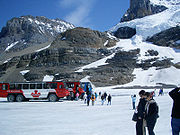
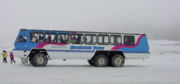
. The Athabasca Glacier has receded significantly since its greatest modern-era extent in 1844. During the summer months visitors to the area can travel onto the glacier in the comfort of large "snowcoaches
Snow coach
A snow coach is a specialized passenger transport vehicle, designed to operate over snow or ice, similar to alarge, multi-passenger snowcat that is equipped with bus style seating. These vehicles may have multiple sets of very large low pressure tires or they may have tracks...
". The Columbia Icefield is also a major destination for ski mountaineering
Ski mountaineering
Ski mountaineering is form of ski touring that variously combines the sports of Telemark, Alpine, and backcountry skiing with that of mountaineering...
in the winter months.
The icefield was first reported in 1898 by J. Norman Collie
J. Norman Collie
John Norman Collie FRS , commonly referred to as J. Norman Collie, was a British scientist, mountaineer, and explorer.- Life and work :He was born in Alderley Edge, Cheshire, the second of four sons...
and Hermann Woolley after they had completed the first ascent
First ascent
In climbing, a first ascent is the first successful, documented attainment of the top of a mountain, or the first to follow a particular climbing route...
of Mount Athabasca.
The Athabasca River
Athabasca River
The Athabasca River originates from the Columbia Glacier of the Columbia Icefield in Jasper National Park in Alberta, Canada...
and the North Saskatchewan River
North Saskatchewan River
The North Saskatchewan River is a glacier-fed river that flows east from the Canadian Rockies to central Saskatchewan. It is one of two major rivers that join to make up the Saskatchewan River....
originate in the Columbia Icefield, as do tributary headwaters of the Columbia River
Columbia River
The Columbia River is the largest river in the Pacific Northwest region of North America. The river rises in the Rocky Mountains of British Columbia, Canada, flows northwest and then south into the U.S. state of Washington, then turns west to form most of the border between Washington and the state...
. As the icefield is atop a triple Continental Divide
Continental Divide
The Continental Divide of the Americas, or merely the Continental Gulf of Division or Great Divide, is the name given to the principal, and largely mountainous, hydrological divide of the Americas that separates the watersheds that drain into the Pacific Ocean from those river systems that drain...
these waters flow ultimately north to the Arctic Ocean
Arctic Ocean
The Arctic Ocean, located in the Northern Hemisphere and mostly in the Arctic north polar region, is the smallest and shallowest of the world's five major oceanic divisions...
, east to Hudson Bay
Hudson Bay
Hudson Bay , sometimes called Hudson's Bay, is a large body of saltwater in northeastern Canada. It drains a very large area, about , that includes parts of Ontario, Quebec, Saskatchewan, Alberta, most of Manitoba, southeastern Nunavut, as well as parts of North Dakota, South Dakota, Minnesota,...
(and thence to the North Atlantic Ocean), and south and west to the Pacific Ocean
Pacific Ocean
The Pacific Ocean is the largest of the Earth's oceanic divisions. It extends from the Arctic in the north to the Southern Ocean in the south, bounded by Asia and Australia in the west, and the Americas in the east.At 165.2 million square kilometres in area, this largest division of the World...
. Hudson Bay, in some watershed divisions, is considered to be in the Arctic watershed, in which case this would arguably not be a triple continental divide point.
External links
- Columbia Icefield - Brewster Snocoach Tours and sightseeing trips in the Canadian Rockies
- The Icefields Parkway
- Columbia Icefield on Bivouac
- The Columbia Icefield and the Athabasca Glacier