

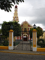
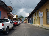
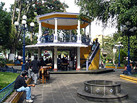
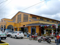
Coatepec
Encyclopedia
Municipalities of Mexico
Municipalities are the second-level administrative division in Mexico . There are 2,438 municipalities in Mexico, making the average municipality population 45,616...
of Coatepec is found in the central region of the Mexican state of Veracruz
Veracruz
Veracruz, formally Veracruz de Ignacio de la Llave officially Estado Libre y Soberano de Veracruz de Ignacio de la Llave , is one of the 31 states that, along with the Federal District, comprise the 32 federative entities of Mexico. It is divided in 212 municipalities and its capital city is...
. Its north latitude is 19° 27', west longitude is 96° 58', altitude of 1200.00 m, and surface of 255.81 km². It represents the 0.338% of the current state. The municipal seat and largest community of the municipality is also called Coatepec. The Mexican census of 2005 reported a population of 49,608 in the city, while the municipality had 79,787 inhabitants. The municipality also includes many smaller communities within its boundaries. The largest of these are Tuzamapan, Pacho Viejo, and Mahuixtlán.
Coatepec borders the municipalities of Xalapa
Xalapa
Xalapa-Enríquez, commonly Xalapa or Jalapa, is the capital city of the Mexican state of Veracruz and the name of the surrounding municipality. In the year 2005 census the city reported a population of 387,879 and the municipality of which it serves as municipal seat reported a population of...
and Tlalnelhuayocan
Tlalnelhuayocan
Tlalnelhuayocan is a city in the Mexican state of Veracruz, located 2 kilometres from state capital Xalapa-Enríquez. It stands on the Mexico City–Veracruz railway and on Federal Highways 180 and 125. Its name was San Andrés Tlalnelhuayocan, who is the first name was used to the Nahuatl and...
(north); Teocelo
Teocelo
Teocelo is a city in the Mexican state of Veracruz, located to 20 km from Jalapa-Enríquez on Federal Highway 180. It is bordered by: Ixhuacán, Xico, and Coatepec. The coffee of Teocelo is one of the better coffees produced in Mexico...
and Jalcomulco
Jalcomulco
Jalcomulco is a municipality in Veracruz, Mexico. It is located in central zone of the State of Veracruz, about , from State Capital, Xalapa and , from Mexico City. It has a surface of 58.40 km2...
(south); Emiliano Zapata
Emiliano Zapata, Veracruz
Emiliano Zapata is a municipality in the Mexican state of Veracruz, located 2 km from Jalapa-Enríquez on Federal Highways 180 and 190. It named for the hero of the Mexican Revolution, Emiliano Zapata.- External links :...
(east); and Xico and Teocelo
Teocelo
Teocelo is a city in the Mexican state of Veracruz, located to 20 km from Jalapa-Enríquez on Federal Highway 180. It is bordered by: Ixhuacán, Xico, and Coatepec. The coffee of Teocelo is one of the better coffees produced in Mexico...
(west).
Often called the capital of Coffee in Mexico, the name Coatepec comes from the Nahuatl
Nahuatl
Nahuatl is thought to mean "a good, clear sound" This language name has several spellings, among them náhuatl , Naoatl, Nauatl, Nahuatl, Nawatl. In a back formation from the name of the language, the ethnic group of Nahuatl speakers are called Nahua...
coatl, serpent and tepetl, hill (The Hill where the Snakes are).
This municipality has four small rivers: the Pixquiac, "Pintores", "Sordo" and Hueyapan; all going to "Pescados" ("La Antigua") river.
Coatepec was named a "Pueblo Mágico
Pueblo Mágico
The Programa Pueblos Mágicos is an initiative led by Mexico's Secretariat of Tourism , in conjunction with other federal and state agencies, to promote a series of towns around the country that offer visitors a "magical" experience – by reason of their natural beauty, cultural riches, or...
" in 2006.
Climate
Coatepec's yearly median temperature is 19.5 °C (67 °F). Seasonal variations in temperature are moderate as elsewhere in central Mexico, whilst precipitation has more pronounced changes. The warmest month is May, when temperatures top 30 °C (86°F) on average, although at night because of the high elevation the mercury drops to 15 °C (59 °F). The coolest month is January with temperatures varying from 9 °C (48 °F) to 22° C (72 °F). Precipitation is at its lowest during the spring months (however still some rainfall falls from late cold fronts or early thunderstorm activity). Rainfall peaks at two times during the year, in June, at the beginning of the rainy season, and in September, towards the end of it. During these months precipitation exceeds on average 300 mm (11.8 in) and have been as high as over 25 in (640.7 mm in September 1974). The city's mild to warm temperatures have their extremes in 33 °C (92 °F) in May 1984 and -1° C (28 °F) during February, 1976. There are 161 days with rain each year, while fog is common during the winter months.External links
- Ayuntamiento de Coatepec Official website for the 2005-2007 administration
- Site with Tourist information about Coatepec
- Site of government Current administration Municipal Official Information
- Cultural festival
- Geographical information in Tagzania
- El Retoño Ecolodge