
Clisham
Encyclopedia
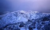
The Clisham is a mountain
on the island of Harris in the Western Isles of Scotland
. At 799 metres (2,621 ft) it is the highest mountain in the Outer Hebrides and the archipelago's only Corbett.
The easiest ascent of the mountain starts from the highest point of the A859 road between Tarbert
and Ardvourlie (Aird a' Mhulaidh), and climbs the broad southern shoulder. A longer and more varied expedition starts at a bridge over the Scaladale River (Abhainn Scaladail) near Ardvourlie, from where the minor summit of Tomnabhal (552 metres (1,811 ft)) may be ascended before continuing on to the Clisham. Many walkers taking this option continue west then north along the ridge, taking in the summits of Mulla-Fo-Deas (743 metres (2,438 ft)), Mulla-Fo-Thuath (720 metres (2,362 ft)) and Mullach an Langa (614 metres (2,014 ft)), thus completing a round known as the Clisham Horseshoe.
Mountain
Image:Himalaya_annotated.jpg|thumb|right|The Himalayan mountain range with Mount Everestrect 58 14 160 49 Chomo Lonzorect 200 28 335 52 Makalurect 378 24 566 45 Mount Everestrect 188 581 920 656 Tibetan Plateaurect 250 406 340 427 Rong River...
on the island of Harris in the Western Isles of Scotland
Scotland
Scotland is a country that is part of the United Kingdom. Occupying the northern third of the island of Great Britain, it shares a border with England to the south and is bounded by the North Sea to the east, the Atlantic Ocean to the north and west, and the North Channel and Irish Sea to the...
. At 799 metres (2,621 ft) it is the highest mountain in the Outer Hebrides and the archipelago's only Corbett.
The easiest ascent of the mountain starts from the highest point of the A859 road between Tarbert
Tarbert, Harris
Tarbert is the main community on Harris in the Western Isles of Scotland. It is also a car ferry terminal to Uig on Skye. Its name means "isthmus".-1990 RAF air crash:...
and Ardvourlie (Aird a' Mhulaidh), and climbs the broad southern shoulder. A longer and more varied expedition starts at a bridge over the Scaladale River (Abhainn Scaladail) near Ardvourlie, from where the minor summit of Tomnabhal (552 metres (1,811 ft)) may be ascended before continuing on to the Clisham. Many walkers taking this option continue west then north along the ridge, taking in the summits of Mulla-Fo-Deas (743 metres (2,438 ft)), Mulla-Fo-Thuath (720 metres (2,362 ft)) and Mullach an Langa (614 metres (2,014 ft)), thus completing a round known as the Clisham Horseshoe.