Clatsop Spit
Encyclopedia


Spit (landform)
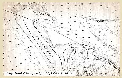
A spit or sandspit is a deposition landform found off coasts. At one end, spits connect to land, and extend into the sea. A spit is a type of bar or beach that develops where a re-entrant occurs, such as at cove's headlands, by the process of longshore drift...
on the Pacific coast
Pacific Ocean
The Pacific Ocean is the largest of the Earth's oceanic divisions. It extends from the Arctic in the north to the Southern Ocean in the south, bounded by Asia and Australia in the west, and the Americas in the east.At 165.2 million square kilometres in area, this largest division of the World...
along U.S. 101 between Astoria
Astoria, Oregon
Astoria is the county seat of Clatsop County, Oregon, United States. Situated near the mouth of the Columbia River, the city was named after the American investor John Jacob Astor. His American Fur Company founded Fort Astoria at the site in 1811...
and the north end of Tillamook Head
Tillamook Head
Tillamook Head is a high promontory on the Pacific coast of northwest Oregon in the United States. It is located in west-central Clatsop County, approximately 5 mi southwest of Seaside. The promontory forms a steep rocky bluff on the ocean, approximately 1,200 ft high, forested with...
in Clatsop County
Clatsop County, Oregon
Clatsop County is a county located in the U.S. state of Oregon. The county is named for the Clatsop tribe of Native Americans, who lived along the coast of the Pacific Ocean prior to European settlement. As of 2010, the population was 37,039. The county seat is Astoria.-Economy:The principal...
, northwest Oregon
Oregon
Oregon is a state in the Pacific Northwest region of the United States. It is located on the Pacific coast, with Washington to the north, California to the south, Nevada on the southeast and Idaho to the east. The Columbia and Snake rivers delineate much of Oregon's northern and eastern...
at the mouth of the Columbia River
Columbia River
The Columbia River is the largest river in the Pacific Northwest region of North America. The river rises in the Rocky Mountains of British Columbia, Canada, flows northwest and then south into the U.S. state of Washington, then turns west to form most of the border between Washington and the state...
. The Clatsop Spit was formed by Columbia River sediment
Sediment
Sediment is naturally occurring material that is broken down by processes of weathering and erosion, and is subsequently transported by the action of fluids such as wind, water, or ice, and/or by the force of gravity acting on the particle itself....
brought to the coast by the river flow after the last ice age ended approximately 8500 years ago and the ocean level rose. Here it worked over and shaped by the wind and the waves until a vast and sandy plain was formed.
Shipwrecks
The seas around Clatsop Spit were known to be treacherous and there were many shipwreckShipwreck
A shipwreck is what remains of a ship that has wrecked, either sunk or beached. Whatever the cause, a sunken ship or a wrecked ship is a physical example of the event: this explains why the two concepts are often overlapping in English....
s, including the paddle steamer
Paddle steamer
A paddle steamer is a steamship or riverboat, powered by a steam engine, using paddle wheels to propel it through the water. In antiquity, Paddle wheelers followed the development of poles, oars and sails, where the first uses were wheelers driven by animals or humans...
General Warren in which 42 people died in the surf in 1852 and in 1859, the schooner
Schooner
A schooner is a type of sailing vessel characterized by the use of fore-and-aft sails on two or more masts with the forward mast being no taller than the rear masts....
Rambler washed up on Clatsop Spit. No trace of her crew was ever found. In 1860, the barque
Barque
A barque, barc, or bark is a type of sailing vessel with three or more masts.- History of the term :The word barque appears to have come from the Greek word baris, a term for an Egyptian boat. This entered Latin as barca, which gave rise to the Italian barca, Spanish barco, and the French barge and...
Leonese washed up on Clatsop Spit upside down and her crew lost. In 1883 the crew of the luxury schooner J.C. Cousins operated by the State of Oregon similarly vanished as she washed ashore. Other shipwrecks include the barquentine
Barquentine
A barquentine is a sailing vessel with three or more masts; with a square rigged foremast and fore-and-aft rigged main, mizzen and any other masts.-Modern barquentine sailing rig:...
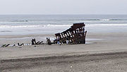
Makah (1888), and the bark Peter Iredale in 1906. It is estimated that since 1800 more than 2,000 vessels and close to 1,000 lives have been lost.
Geology
After the sea level along the coast rose to its current level approximately 8,500 years ago at the end of the last ice ageIce age
An ice age or, more precisely, glacial age, is a generic geological period of long-term reduction in the temperature of the Earth's surface and atmosphere, resulting in the presence or expansion of continental ice sheets, polar ice sheets and alpine glaciers...
, seasonal prevailing winds drove the Columbia River's sandy sediment to the Washington beaches in the winter and to Oregon's Clatsop Spit during the summer months. Through this process the sandy beaches grew dynamically to their present size, but it is unlikely they will continue this fast growth. Most of the sediment generated by the Columbia River is now trapped by a series of dams before it reaches the coast. Meanwhile, when the tide is out constantly shifting onshore winds blow sand from the exposed beaches inland on to huge sand dunes. However, during the 1930s most of the spectacular dunes were deliberately controlled by the planting of grass and shrubs to prevent the natural movement of the sand. Now the sand is stabilized by the covering of vegetation and are no longer endlessly in motion, dynamically shaped by the wind.
Clatsop Spit is now part of Fort Stevens State Park
Lewis and Clark National and State Historical Parks
The Lewis and Clark National and State Historical Parks, in the vicinity of the mouth of the Columbia River, commemorate the Lewis and Clark Expedition...
.

