
Clarkia, Idaho
Encyclopedia
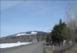
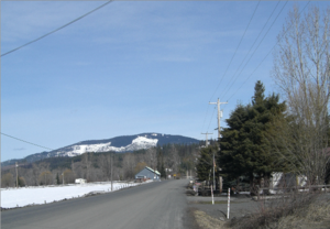
Clarkia is a small unincorporated town
Unincorporated area
In law, an unincorporated area is a region of land that is not a part of any municipality.To "incorporate" in this context means to form a municipal corporation, a city, town, or village with its own government. An unincorporated community is usually not subject to or taxed by a municipal government...
in the southwestern corner of Shoshone County
Shoshone County, Idaho
Shoshone County is a county located in the U.S. state of Idaho. The county was established in 1864, named for the Native American Shoshone tribe. The population was 12,765 at the 2010 census. Shoshone County is commonly referred to as the Silver Valley, due to its century-old mining history...
, Idaho
Idaho
Idaho is a state in the Rocky Mountain area of the United States. The state's largest city and capital is Boise. Residents are called "Idahoans". Idaho was admitted to the Union on July 3, 1890, as the 43rd state....
United States
United States
The United States of America is a federal constitutional republic comprising fifty states and a federal district...
. It is surrounded by publicly and privately managed forest lands of Douglas-fir
Douglas-fir
Douglas-fir is one of the English common names for evergreen coniferous trees of the genus Pseudotsuga in the family Pinaceae. Other common names include Douglas tree, and Oregon pine. There are five species, two in western North America, one in Mexico, and two in eastern Asia...
, Ponderosa Pine
Ponderosa Pine
Pinus ponderosa, commonly known as the Ponderosa Pine, Bull Pine, Blackjack Pine, or Western Yellow Pine, is a widespread and variable pine native to western North America. It was first described by David Douglas in 1826, from eastern Washington near present-day Spokane...
, and Western Larch
Western Larch
Western Larch is a species of larch native to the mountains of western North America, in Canada in southeastern British Columbia and southwestern Alberta, and in the United States in eastern Washington, eastern Oregon, northern Idaho and western Montana.It is a large deciduous coniferous tree...
. Located just to the east of State Highway 3
Idaho State Highway 3
Idaho State Highway 3 is a state highway in northern Idaho connecting US 12 near Spalding with I-90 near Rose Lake. It is long and runs north–south.-Route description:...
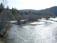
, the town is in the drainage area of the West Fork of the St. Maries River.
History
The Coeur d’AleneCoeur d'Alene Tribe
The Coeur d'Alene are a Native American people who lived in villages along the Coeur d'Alene, St. Joe, Clark Fork and Spokane Rivers; as well as sites on the shores of Lake Coeur d'Alene, Lake Pend Oreille and Hayden Lake, in what is now northern Idaho, eastern Washington and western Montana.In...
people inhabited this area for thousands of years prior to the coming of white settlers. The native name of the area is Chatnna or Meadow. The first residents of the town of Clarkia harvested the Western White Pine
Western White Pine
Western White Pine, Pinus monticola in the family Pinaceae, is a species of pine that occurs in the mountains of the western United States and Canada, specifically the Sierra Nevada, the Cascade Range, the Coast Range, and the northern Rocky Mountains. The tree extends down to sea level in many...
in the area for lumber.
Demographics
The 2000 census recorded a population of 97 with an average household income of $39,375. The median age in Clarkia is 37.8 and the average household size is 2.68. In 2000 the agriculture industry made up 40.5% of the jobs in the area, while educational, health and social services jobs accounted for the next largest segment at 21.4%. Workers for government agencies are the largest class of worker at 47.6%. The city shares a K-8 school district with the communities of AveryAvery, Idaho
Avery is a small unincorporated town nestled in the St. Joe River Valley in Shoshone County, Idaho, United States. Avery is located in the middle of the St. Joe District of the Idaho Panhandle National Forest...
and Calder
Calder, Idaho
Calder is an unincorporated community in Shoshone County, Idaho, United States. Calder is located on the Saint Joe River east of St. Maries. Calder has a post office with ZIP code 83808....
. Currently, all students attend school in the St. Maries
St. Maries, Idaho
St. Maries is a city in Benewah County, Idaho, United States. The population was 2,652 at the 2000 census. The city is the county seat of Benewah County. Pronounced St. Mary's.-Geography:St. Maries is located at ....
district.
Physical geography
Miocene
The Miocene is a geological epoch of the Neogene Period and extends from about . The Miocene was named by Sir Charles Lyell. Its name comes from the Greek words and and means "less recent" because it has 18% fewer modern sea invertebrates than the Pliocene. The Miocene follows the Oligocene...
Epoch Lake Clarkia. The sediments from this lake contain abundant and well-preserved fossils of mid-Miocene
Miocene
The Miocene is a geological epoch of the Neogene Period and extends from about . The Miocene was named by Sir Charles Lyell. Its name comes from the Greek words and and means "less recent" because it has 18% fewer modern sea invertebrates than the Pliocene. The Miocene follows the Oligocene...
flora and are well exposed at the Fossil Bowl, an open-to-the-public fossil dig and motorcross racetrack located on Highway 3 in Clarkia. The West and Middle Forks of the St. Maries River
Saint Maries River
Saint Maries River is a river located in the U.S. state of Idaho. It is a tributary of Coeur d'Alene Lake and thus part of the Spokane River drainage basin and the Columbia River Basin. The West and Middle Forks of the river join near Clarkia, Idaho and run parallel to State Highway 3 in a...
join near Clarkia and run parallel to State Highway 3 in a northwesterly direction to St. Maries. The area is on the eastern edge of the Columbia River Plateau
Columbia River Plateau
The Columbia Plateau is a geologic and geographic region that lies across parts of the U.S. states of Washington, Oregon, and Idaho. It is a wide flood basalt plateau between the Cascade Range and the Rocky Mountains, cut through by the Columbia River...
and is to the west of the Bitterroot Mountains
Bitterroot Mountains
The Northern and Central Bitterroot Range, collectively the Bitterroot Mountains, is the largest portion of the Bitterroot Range, part of the Rocky Mountains, located in the panhandle of Idaho and westernmost Montana in the Western United States...
.