
Claremont, Western Australia
Encyclopedia
Perth, Western Australia
Perth is the capital and largest city of the Australian state of Western Australia and the fourth most populous city in Australia. The Perth metropolitan area has an estimated population of almost 1,700,000....
, Western Australia
Western Australia
Western Australia is a state of Australia, occupying the entire western third of the Australian continent. It is bounded by the Indian Ocean to the north and west, the Great Australian Bight and Indian Ocean to the south, the Northern Territory to the north-east and South Australia to the south-east...
on the north bank of the Swan River
Swan River (Western Australia)
The Swan River estuary flows through the city of Perth, in the south west of Western Australia. Its lower reaches are relatively wide and deep, with few constrictions, while the upper reaches are usually quite narrow and shallow....
.
History
Prior to European settlement, the NoongarNoongar
The Noongar are an indigenous Australian people who live in the south-west corner of Western Australia from Geraldton on the west coast to Esperance on the south coast...
people used the area as a source of water, for fishing and for catching waterfowl. In 1830, John Butler, a settler, set up an inn at Freshwater Bay (in modern-day Peppermint Grove
Peppermint Grove, Western Australia
Peppermint Grove is an affluent western suburb of Perth, Western Australia on the north bank of the Swan River at Freshwater Bay. Its Local Government Area, the smallest in the country, is the Shire of Peppermint Grove. The suburb was named after its trademark "Peppermint trees" lining many streets...
) to attract travellers on the road from Perth
Perth, Western Australia
Perth is the capital and largest city of the Australian state of Western Australia and the fourth most populous city in Australia. The Perth metropolitan area has an estimated population of almost 1,700,000....
to Fremantle
Fremantle
Freemantle is a suburb of Southampton in England.Fremantle or Freemantle may also refer to:- Places :* Fremantle, the port city to the capital Perth, Western Australia...
. After the arrival of convicts in the colony in 1850, work began on constructing the Fremantle Road
Stirling Highway
Stirling Highway is, for most of its length, a four-lane single carriageway and major arterial road between Perth, Western Australia and the port city of Fremantle in Western Australia on the northern side of the Swan River. The speed limit is 60 km/h...
. The Government allocated land on the foreshore and at Lake Claremont (then known as Butler's Swamp) to 19 pensioner guards and their families, and a permanent convict depot was established on Freshwater Bay, operating until 1875.
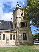
As the community grew, a school (1862) and church were built, and a community grew around what is now Victoria Avenue. In the 1870s, a number of influential men, including the Trigg, Sandover and Stirling families, bought land in the district and settled in what is now the Christ Church Grammar School and surrounding areas. Some of their homes have been maintained as school buildings.
In 1881, the railway line from Perth to Fremantle came through and the community's focus shifted to the area between Fremantle Road (Stirling Highway) and the railway, particularly around Bay View Terrace. The community was named Claremont by Mr James Morrison, the owner of Swan Location
Swan Land District
Swan Land District is one of the land districts of Western Australia, which is located within the South West Division. It covers all of the northern and eastern suburbs of Perth, as well as some inner southern areas such as Belmont and Applecross and the area to the north up to the Moore River,...
702, after his wife, Clara - the name was first used for the railway station in 1883. The Freshwater Bay school ceased to play a central role, and became a boarding house nicknamed "Appy One" in 1892 (and in 1975 a museum).
Land speculators bought in the area and subdivided blocks at varying sizes, leading to a wide class diversity within the suburb. By about 1903, the entire suburb, other than a dozen or so streets, had been subdivided, and by the Second World War, the community was firmly established.
Geography
Claremont is bounded by Airlie Street to the south; Stirling HighwayStirling Highway
Stirling Highway is, for most of its length, a four-lane single carriageway and major arterial road between Perth, Western Australia and the port city of Fremantle in Western Australia on the northern side of the Swan River. The speed limit is 60 km/h...
, Congdon Street and Stirling Road to the west; Alfred Road to the north and Loch Street and Bay Road to the east. A large part of Claremont is residential, although a significant shopping area is located along Stirling Highway, and the Claremont Showgrounds
Claremont Showgrounds
The Claremont Showgrounds were built in 1905 in the Perth suburb of Claremont. The Showgrounds are home to the annual Perth Royal Show. They were also the original home of Claremont-Cottesloe in its first year in the WAFL before moving to Claremont Oval....
and the eastern half of Lake Claremont are within Claremont's boundaries.
Claremont has grand homes in the Agett Road and Richardson Avenue areas on the south side of Stirling Highway, while lesser areas include the areas around Ashton Avenue to the north.
At the ABS
Australian Bureau of Statistics
The Australian Bureau of Statistics is Australia's national statistical agency. It was created as the Commonwealth Bureau of Census and Statistics on 8 December 1905, when the Census and Statistics Act 1905 was given Royal assent. It had its beginnings in section 51 of the Constitution of Australia...
2001 census, Claremont had a population of 6,406 people living in 3,502 dwellings, many of which were flats or townhouses. The ABS identified property and health as the two main occupations.
Facilities
Claremont includes the Claremont ShowgroundsClaremont Showgrounds
The Claremont Showgrounds were built in 1905 in the Perth suburb of Claremont. The Showgrounds are home to the annual Perth Royal Show. They were also the original home of Claremont-Cottesloe in its first year in the WAFL before moving to Claremont Oval....
and the Claremont Oval, home ground of the Claremont Football Club
Claremont Football Club
The Claremont Football Club, nicknamed the Tigers, is an Australian rules football club in the West Australian Football League . Its official colours are navy blue and gold....
, as well as a significant shopping area along Stirling Highway, most concentrated on the St Quentins Avenue precinct. The suburb also contains several nightspots including Claremont Hotel, On the Terrace and Club Bay View.
Several private schools including Methodist Ladies' College
Methodist Ladies' College, Perth
The Methodist Ladies' College, Perth , is an independent, Uniting Church, day and boarding school for girls, located in Claremont, a western suburb of Perth, Western Australia....
, Christ Church Grammar School
Christ Church Grammar School
Christ Church Grammar School is an independent, Anglican day and boarding school for boys from Pre-Primary to Year 12. Located in Perth, Western Australia, the school overlooks the Swan River at Freshwater Bay in Claremont....
, Presbyterian Ladies' College
Presbyterian Ladies' College, Perth
The Presbyterian Ladies' College , is an independent, day and boarding school predominantly for girls, situated in Peppermint Grove, a western suburb of Perth, Western Australia....
and Scotch College
Scotch College, Perth
Scotch College , is one of Australia's leading independent schools for boys, situated in Swanbourne, Western Australia, Australia. The school is a member of the Public Schools Association and is now a Uniting Church school, although it was founded in 1897 by the Presbyterian Church of Australia...
are either in Claremont or within 50 m of the suburb boundary. Claremont also contains a small private hospital (Bethesda) and two state primary schools; Claremont Primary School and East Claremont Primary School, as well as a number of jetties on the Swan River.
Every year, Claremont hosts the annual Perth Royal Show
Perth Royal Show
The Perth Royal Show is an annual show held in Perth, Western Australia at the Claremont Showgrounds. It features informational exhibits, agricultural competitions and display animals, a fairground and rides, and showbags. It has been held for over 100 years and is organised by the Royal...
.
Transport
Claremont is served by the Claremont railway stationClaremont railway station, Perth
Claremont Station is a Transperth railway station 9.3 km from Perth station, in Western Australia, on the Fremantle Line. It is the westernmost station in Zone 1 on the Fremantle Line and is located approximately halfway between Perth and Fremantle. The disused signalling cabin at the station...
and Loch Street railway station at regular times, as well as the Showgrounds railway station
Showgrounds railway station, Perth
Showgrounds Train Station is a Transperth train station 8.6 km from Perth Train Station, in Western Australia, on the Fremantle Line. It is opposite the Claremont Showgrounds, and is used only during special events, such as the Perth Royal Show....
during special events. Various buses, including the CircleRoute
CircleRoute
The CircleRoute is a pair of suburban bus routes in Perth, Western Australia. Like all Perth bus routes, the buses are branded Transperth and operated by companies contracted by the Public Transport Authority. The routes are identical except for direction: 98 is clockwise, and 99 is anticlockwise...
, travel along Stirling Highway
Stirling Highway
Stirling Highway is, for most of its length, a four-lane single carriageway and major arterial road between Perth, Western Australia and the port city of Fremantle in Western Australia on the northern side of the Swan River. The speed limit is 60 km/h...
and through Claremont's northern and southern sections. All services are operated by the Public Transport Authority.
Politics
Claremont is part of the federal division of CurtinDivision of Curtin
The Division of Curtin is an Australian Electoral Division in Western Australia. The division was created in 1949 and is named for John Curtin, who was Prime Minister of Australia 1941-45. It is located in the wealthy beachside suburbs of Perth, including Claremont, Cottesloe, Mosman Park,...
. The federal seat is held by the centre-right
Centre-right
The centre-right or center-right is a political term commonly used to describe or denote individuals, political parties, or organizations whose views stretch from the centre to the right on the left-right spectrum, excluding far right stances. Centre-right can also describe a coalition of centrist...
Liberal Party
Liberal Party of Australia
The Liberal Party of Australia is an Australian political party.Founded a year after the 1943 federal election to replace the United Australia Party, the centre-right Liberal Party typically competes with the centre-left Australian Labor Party for political office...
. It is regarded as a safe seat as it has been continually retained by the Liberal Party
Liberal Party of Australia
The Liberal Party of Australia is an Australian political party.Founded a year after the 1943 federal election to replace the United Australia Party, the centre-right Liberal Party typically competes with the centre-left Australian Labor Party for political office...
with the exception of former Liberal member Allan Rocher
Allan Rocher
Allan Rocher , Australian politician, is a former Liberal Party of Australia Senator for Western Australia from 1978 to 1981 and member of the Australian House of Representatives Division of Curtin from 1981 to 1998. Up until 1996 he represented the Liberal Party of Australia.Rocher was born in...
as an Independent politician between 1996 and 1998. For the parliament of Western Australia, Claremont is divided between the state electoral districts of Cottesloe
Electoral district of Cottesloe
The Electoral district of Cottesloe is a Legislative Assembly electorate in the state of Western Australia. Cottesloe is named for the western Perth suburb of Cottesloe which falls within its borders.-History:...
and Nedlands
Electoral district of Nedlands
The Electoral district of Nedlands is a Legislative Assembly electorate in the state of Western Australia. Nedlands is named for the inner western Perth suburb of Nedlands which falls within its borders.-History:...
, both held by the Liberal Party
Liberal Party of Australia
The Liberal Party of Australia is an Australian political party.Founded a year after the 1943 federal election to replace the United Australia Party, the centre-right Liberal Party typically competes with the centre-left Australian Labor Party for political office...
.
See also
- Claremont serial murders - unsolved murders in Claremont during the 1990s
- Town of ClaremontTown of ClaremontThe Town of Claremont is a Local Government Area in the inner western suburbs of the Western Australian capital city of Perth, located about halfway between the port city of Fremantle and Perth's central business district...
- Claremont Football ClubClaremont Football ClubThe Claremont Football Club, nicknamed the Tigers, is an Australian rules football club in the West Australian Football League . Its official colours are navy blue and gold....
- Claremont ShowgroundsClaremont ShowgroundsThe Claremont Showgrounds were built in 1905 in the Perth suburb of Claremont. The Showgrounds are home to the annual Perth Royal Show. They were also the original home of Claremont-Cottesloe in its first year in the WAFL before moving to Claremont Oval....