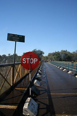
Chirundu Bridge
Encyclopedia

Chirundu, Zambia
Chirundu, Zambia is a town in Zambia at the border with Zimbabwe and is a key point on the Great North Road. It is the site of two of the five major road or rail bridges across the Zambezi river, the Chirundu Bridges....
, Zambia
Zambia
Zambia , officially the Republic of Zambia, is a landlocked country in Southern Africa. The neighbouring countries are the Democratic Republic of the Congo to the north, Tanzania to the north-east, Malawi to the east, Mozambique, Zimbabwe, Botswana and Namibia to the south, and Angola to the west....
and the village of Chirundu
Chirundu, Zimbabwe
Chirundu is a village and border post in Zimbabwe on the border with Zambia, in Mashonaland West province. It is located on the banks of the Zambezi river, and as a result it lies in the hot Zambezi Valley. It is the site of the Chirundu Bridges, two of only five road or rail bridges across the...
, Zimbabwe
Zimbabwe
Zimbabwe is a landlocked country located in the southern part of the African continent, between the Zambezi and Limpopo rivers. It is bordered by South Africa to the south, Botswana to the southwest, Zambia and a tip of Namibia to the northwest and Mozambique to the east. Zimbabwe has three...
. At this location around 65 km downstream from the Kariba Dam
Kariba Dam
The Kariba Dam is a hydroelectric dam in the Kariba Gorge of the Zambezi river basin between Zambia and Zimbabwe. It is one of the largest dams in the world, standing tall and long.- Construction :...
the river is about 400 m wide. The bridges carry the Harare
Harare
Harare before 1982 known as Salisbury) is the largest city and capital of Zimbabwe. It has an estimated population of 1,600,000, with 2,800,000 in its metropolitan area . Administratively, Harare is an independent city equivalent to a province. It is Zimbabwe's largest city and its...
to Lusaka
Lusaka
Lusaka is the capital and largest city of Zambia. It is located in the southern part of the central plateau, at an elevation of about 1,300 metres . It has a population of about 1.7 million . It is a commercial centre as well as the centre of government, and the four main highways of Zambia head...
section of the Great North Road
Great North Road (Zambia)
The Great North Road is a major route in Zambia, running north from Lusaka through Kabwe, Kapiri Mposhi Serenje, Mpika, Kasama, Mbala and Mpulungu. 82km North of Mpika is a signposted left turn onto a well maintained gravel road leading to Shiwa Ng'andu and Kapishya Hot Springs...
, which extends between South Africa and East Africa, and was once seen as part of a Cape to Cairo Road
Cape to Cairo Road
The Cape to Cairo Road or 'Pan-African Highway', sometimes called the Great North Road in sub-Saharan Africa, was an imperial dream envisioned by the British Empire that would see a road stretch the length of Africa, from Cape Town to Cairo, similar to the Pan-American Highway...
.
Chirundu is the only town on the Zambezi where two bridges cross the river.
The Otto Beit Bridge (1939)
The first Chirundu Bridge is the Otto Beit Bridge built in 1938-9 by the Cleveland Bridge Company and financed by the Beit Trust, which funded most of central and southern Africa's colonial era bridges including the Beit Bridge across the Limpopo RiverLimpopo River
The Limpopo River rises in central southern Africa, and flows generally eastwards to the Indian Ocean. It is around long, with a drainage basin in size. Its mean annual discharge is 170 m³/s at its mouth...
, the Kafue Bridge, and the Luangwa Bridge
Luangwa Bridge
The Luangwa Bridge is the only large bridge and the principal engineering challenge on Zambia's Great East Road, crossing the lower Luangwa River where it flows from the Luangwa Rift Valley into the Zambezi valley....
. The Otto Beit Bridge was the first modern suspension bridge outside the United States built with parallel wire cables. It has a span of 382 m (main span 320 m). As it was built two decades before the Kariba Dam, the engineers had to consider the annual Zambezi flood, now tamed by the dam: hence the requirement for a single span (which the second bridge did not need). It cost £186,000 to build and was opened on 24 May 1939 by Lady Lillian Beit, widow of Otto Beit
Otto Beit
Sir Otto John Beit, 1st Baronet, KCMG, FRS was a German-born British financier, philanthropist and art connoisseur.- Life history and career :...
.
The Otto Beit Bridge is a single-lane bridge, with traffic operating in alternating directions, leading to congestion. Secondly the maintenance of steel suspension bridges is considerable, with cables needing replacement when they corrode, and the age of the bridge also places restrictions on the loads it can carry. Consequently Zambia identified the need for a second bridge.

