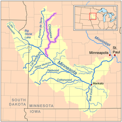
Chippewa River (Minnesota)
Encyclopedia

Tributary
A tributary or affluent is a stream or river that flows into a main stem river or a lake. A tributary does not flow directly into a sea or ocean...
of the Minnesota River
Minnesota River
The Minnesota River is a tributary of the Mississippi River, approximately 332 miles long, in the U.S. state of Minnesota. It drains a watershed of nearly , in Minnesota and about in South Dakota and Iowa....
, about 120 mi (195 km) long, in western and southwestern Minnesota
Minnesota
Minnesota is a U.S. state located in the Midwestern United States. The twelfth largest state of the U.S., it is the twenty-first most populous, with 5.3 million residents. Minnesota was carved out of the eastern half of the Minnesota Territory and admitted to the Union as the thirty-second state...
in the United States. Via the Minnesota River, it is part of the watershed
Drainage basin
A drainage basin is an extent or an area of land where surface water from rain and melting snow or ice converges to a single point, usually the exit of the basin, where the waters join another waterbody, such as a river, lake, reservoir, estuary, wetland, sea, or ocean...
of the Mississippi River
Mississippi River
The Mississippi River is the largest river system in North America. Flowing entirely in the United States, this river rises in western Minnesota and meanders slowly southwards for to the Mississippi River Delta at the Gulf of Mexico. With its many tributaries, the Mississippi's watershed drains...
.
Course
The Chippewa River issues from Chippewa Lake in Douglas CountyDouglas County, Minnesota
As of the census of 2000, there were 32,821 people, 13,276 households, and 9,027 families residing in the county. The population density was 52 people per square mile . There were 16,694 housing units at an average density of 26 per square mile...
, 7 mi (11.3 km) northwest of Alexandria
Alexandria, Minnesota
As of the census of 2000, there were 8,820 people, however the most recent count suggests a population upwards of 10,000, which is displayed on Alexandria's city limits signs. The census lists 4,047 households, and 2,011 families residing in the city. The population density was 992.5 people per...
, and passes through several lakes in its upper course. It initially flows westwardly into Grant County
Grant County, Minnesota
As of the census of 2000, there were 6,289 people, 2,534 households, and 1,740 families residing in the county. The population density was 12 people per square mile . There were 3,098 housing units at an average density of 6 per square mile...
, where it turns generally southward for the remainder of its course through Pope
Pope County, Minnesota
As of the census of 2000, there were 11,236 people, 4,513 households, and 3,064 families residing in the county. The population density was 17 people per square mile . There were 5,827 housing units at an average density of 9 per square mile...
, Stevens
Stevens County, Minnesota
As of the census of 2000, there were 10,053 people, 3,751 households, and 2,366 families residing in the county. The population density was 18 people per square mile . There were 4,074 housing units at an average density of 7 per square mile...
, Swift
Swift County, Minnesota
As of the census of 2000, there were 11,956 people, 4,353 households, and 2,881 families residing in the county. The population density was 16 people per square mile . There were 4,821 housing units at an average density of 6 per square mile...
and Chippewa
Chippewa County, Minnesota
As of the census of 2000, there were 13,088 people, 5,361 households, and 3,597 families residing in the county. The population density was 22 people per square mile . There were 5,855 housing units at an average density of 10 per square mile...
Counties. The river passes the towns of Hoffman
Hoffman, Minnesota
As of the census of 2000, there were 672 people, 274 households, and 164 families residing in the city. The population density was 319.9 people per square mile . There were 307 housing units at an average density of 146.2 per square mile . The racial makeup of the city was 98.36% White, 0.45%...
, Cyrus
Cyrus, Minnesota
Cyrus is a city in Pope County in the U.S. State of Minnesota, United States, along the Chippewa River. The population was 288 at the 2010 census.-Geography:According to the United States Census Bureau, the city has a total area of , all of it land....
and Benson
Benson, Minnesota
As of the census of 2000, there were 3,376 people, 1,451 households, and 880 families residing in the city. The population density was 1,360.5 people per square mile . There were 1,566 housing units at an average density of 631.1 per square mile...
; it joins the Minnesota River in Montevideo
Montevideo, Minnesota
As of the census of 2000, there were 5,346 people, 2,353 households, and 1,444 families residing in the city. The population density was 1,190.5 people per square mile . There were 2,551 housing units at an average density of 568.1 per square mile...
. Some sections of the river, especially along its middle course in Pope and Swift Counties, have been straightened and channelized.
In Pope County, the river collects the Little Chippewa River, about 45 mi (70 km) long, which flows generally southwestwardly through Douglas and Pope Counties. At Benson it collects the East Branch Chippewa River, about 90 mi (145 km) long, which rises in southeastern Douglas County and flows initially southward through Pope County, passing through several lakes, into Swift County, where it turns westward.

