
Chidham
Encyclopedia
Chidham is a civil parish
in the District of Chichester
in West Sussex
, England
located seven kilometres (5 miles) west of Chichester
, south of the A27 road, near Bosham
.
s) and primitive saltern
s were being made here.
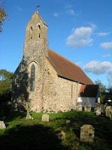
may have been born here, c.681. The village's name is derived from the Old English words ceod (meaning bag or pouch) and ham (meaning settlement), referring to the shape of the peninsula on which it is situated. The present flint and rubble church, St. Mary's, dates from the 13th century, and may have had a wooden predecessor. The peninsula is not mentioned in the Domesday Book
because it was part of the Manor
or Chapelry of Bosham, rich in farming land and then belonging to the bishop of Exeter
.
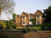 Close to the church of St.Mary is the manor house
, a large late 17th century building. The manor house has had recent work done with permission from the council. There is also a large 18th century Old Rectory, now a private house.
In 1812 an embankment wall was built from Chidham to Bosham, where use was made of an old quay. Writing of Bosham in the 1860s Charles Longcroft described how the newly enclosed land was ploughed and planted with corn. 'But one November, there came a raging tide and a gale wind, from the southwest and away went the embankment..'. In 1825 the sea returned covering the farmland and inundating new buildings. One of these is said to have been a mansion, standing at Cutmill whose stone was afterwards used to build Cutmill Cottage.
The local authority area called ‘The Parish of Chidham’ is a small rural parish situated five miles (8 km) west of Chichester and comprises two villages - Hambrook and Chidham. The residents of part of a third village, Nutbourne, are also part of the Chidham and Hambrook community, but because of the vagaries of local government, technically fall outside the parish.
There is a network of public footpaths for walkers, giving access to the shore and intertidal mudflats of Chichester harbour. The land is largely flat, and agricultural, but with sufficient variety and cover for a variety of wildlife.
Parts of the Chidham peninsula are potentially at risk from tidal flooding. The west tidebank is in a poor state, but the Harbour Conservancy proposes to realign a section of the bank in Autumn 2005; this will have the added benefit of creating 22 hectares (54.4 acre) of intertidal habitat. Elsewhere, the tidebanks are in generally good condition.
The present flint and rubble church only dates from the 13th century - a wooden one may have stood here before. Close by is the manor house, a large late 17th century building but of greater interest to many people is the nearby pub, the 'Old House at Home' which offers a selection of real ales.
A significant proportion of residents are relatively new to their current home, with 36% having lived there for less than six years. On the other hand, 18% have occupied their home for more than twenty-five years.
Most homes (83%) are owner-occupied and 99% of dwellings are the household's main residence The people of the community are evenly divided between the sexes (48% male, 52% female) and the age distribution of people over 11 years old is more uniform than might be expected. 8% of residents are aged between 11 and 17 years and 9% are aged 75 years or more. Children under 11 years old constitute 14% of the population. The picture that emerges is of a community with a good mix.
The parish is cut by two east-west lines of communication - the A259 and the Portsmouth to Brighton railway line. The Chidham peninsula extends southwards into Chichester Harbour and lies within an Area of Outstanding Beauty (AONB). The whole of the parish, with the exception of two Settlement Policy Areas (SPA's), lies within the Rural Area, as defined in the Chichester District Local Plan.
There are 705 households in the community, with a total population of about 1800, including children. The population is concentrated in three areas. There is no single focal point in the community. Around 41% of the households lie to the north of the railway line and 49% to the south; the remainder are technically part of Nutbourne, also to the south of the Railway line.
The parish is served by a railway halt and a half-hour bus service along the A259. There is a primary school, a church, a village hall and a church centre. Facilities include a post office/shop, a garage/shop, three inns, two riding stables, three caravan sites and three residential nursing homes. Further employment is provided by arable farming, market gardening, nurseries and orchards and also a national concrete product manufacturer and several small rural businesses. The youth of West Sussex and elsewhere are catered for by two activity centres, each having a strong sailing bias, located adjacent to the Bosham Channel where there is also a dinghy park and slipway.
The civil Parish of Chidham was increased in area in April 2003, when the west side of Broad Road north of the railway line, Priors Leaze Lane , Hambrook Hill South and Shepherd's Meadow were included. This brought the whole of the Hambrook community into the parish. However, a similar proposal to bring part of Nutbourne into the parish was not implemented. Over the last 10 years from 1995 to date, there have been approximately 72 new houses built within the current parish of Chidham. Most of these are to the north of the railway line in Hambrook. In addition to these, several conversions of existing buildings into dwellings have also taken place and approximately 10 new houses have been built within the additional consultation area in Nutbourne. The Shepherd's Meadow development in 1999 is of note in that 36 houses were constructed on a single site, allocated in the Local Plan, between Hambrook Hill South and Broad Road .
Local organisations include the Parish Council which has nine elected members. The Hambrook and District Residents' Association (HDRA) currently represents 126 households. Chidham WI meets monthly in the Village Hall and draws members from both within and outside the parish. St Mary's Church has a thriving congregation and Chidham Parochial Primary School, with 91 pupils, has an active Parents, Teachers and Friends' Association. Clubs and societies meet in both the Village Hall and St Wilfrid's Church Centre.
, a Site of Special Scientific Interest
is partly within the parish. This is a wetland of international importance,a Special Protection Area for wild birds and a Special Area of Conservation. The harbour is of particular importance for wintering wildfowl and waders of which five species reach numbers which are internationally important.
Civil parish
In England, a civil parish is a territorial designation and, where they are found, the lowest tier of local government below districts and counties...
in the District of Chichester
Chichester (district)
Chichester is a largely rural local government district in West Sussex, England. Its council is based in the city of Chichester.-History:The district was formed on 1 April 1974, under the Local Government Act 1972, as a merger of the municipal borough of Chichester and the Rural Districts of...
in West Sussex
West Sussex
West Sussex is a county in the south of England, bordering onto East Sussex , Hampshire and Surrey. The county of Sussex has been divided into East and West since the 12th century, and obtained separate county councils in 1888, but it remained a single ceremonial county until 1974 and the coming...
, England
England
England is a country that is part of the United Kingdom. It shares land borders with Scotland to the north and Wales to the west; the Irish Sea is to the north west, the Celtic Sea to the south west, with the North Sea to the east and the English Channel to the south separating it from continental...
located seven kilometres (5 miles) west of Chichester
Chichester
Chichester is a cathedral city in West Sussex, within the historic County of Sussex, South-East England. It has a long history as a settlement; its Roman past and its subsequent importance in Anglo-Saxon times are only its beginnings...
, south of the A27 road, near Bosham
Bosham
Bosham is a small coastal village and civil parish in the Chichester District of West Sussex, England, about ) west of Chichester on an inlet of Chichester Harbour....
.
Prehistory
A recent excavation has shown that man made use of Chidham more than 4000 years ago. The flint scrapers discovered on the site on the western shore of the peninsula, seem to suggest that spear shafts or kiddles (fish trapFish trap
A fish trap is a trap used for fishing. Fish traps may have the form of a fishing weir or a lobster trap. A typical trap might consist of a frame of thick steel wire in the shape of a heart, with chicken wire stretched around it. The mesh wraps around the frame and then tapers into the inside of...
s) and primitive saltern
Saltern
Saltern is a word with a number of differing meanings. In English archaeology, a saltern is an area used for salt making, especially in the East Anglian fenlands....
s were being made here.
Saxon, Norman and medieval
The Saxon Saint CuthmanCuthman of Steyning
Saint Cuthmann of Steyning was an Anglo-Saxon hermit, church-builder and saint.-Birth:In the biographies of the saints called the Acta Sanctorum which were preserved at the Abbey of Fécamp in Normandy it is said that he was born about 681 A.D., either in Devon or Cornwall, or more probably at...
may have been born here, c.681. The village's name is derived from the Old English words ceod (meaning bag or pouch) and ham (meaning settlement), referring to the shape of the peninsula on which it is situated. The present flint and rubble church, St. Mary's, dates from the 13th century, and may have had a wooden predecessor. The peninsula is not mentioned in the Domesday Book
Domesday Book
Domesday Book , now held at The National Archives, Kew, Richmond upon Thames in South West London, is the record of the great survey of much of England and parts of Wales completed in 1086...
because it was part of the Manor
Manorialism
Manorialism, an essential element of feudal society, was the organizing principle of rural economy that originated in the villa system of the Late Roman Empire, was widely practiced in medieval western and parts of central Europe, and was slowly replaced by the advent of a money-based market...
or Chapelry of Bosham, rich in farming land and then belonging to the bishop of Exeter
Bishop of Exeter
The Bishop of Exeter is the Ordinary of the Church of England Diocese of Exeter in the Province of Canterbury. The incumbent usually signs his name as Exon or incorporates this in his signature....
.
17th & 18th century
Manor house
A manor house is a country house that historically formed the administrative centre of a manor, the lowest unit of territorial organisation in the feudal system in Europe. The term is applied to country houses that belonged to the gentry and other grand stately homes...
, a large late 17th century building. The manor house has had recent work done with permission from the council. There is also a large 18th century Old Rectory, now a private house.
19th century
The men of Chidham seem to have been farmers rather than fishermen or sailors, probably due to the good quality of the soil.In 1812 an embankment wall was built from Chidham to Bosham, where use was made of an old quay. Writing of Bosham in the 1860s Charles Longcroft described how the newly enclosed land was ploughed and planted with corn. 'But one November, there came a raging tide and a gale wind, from the southwest and away went the embankment..'. In 1825 the sea returned covering the farmland and inundating new buildings. One of these is said to have been a mansion, standing at Cutmill whose stone was afterwards used to build Cutmill Cottage.
20th century
During World War II bombs were recorded as having fallen within the parish of Chidham. On the night of 8 October 1940 the vicarage, now the Old Rectory, was damaged by an incendiary, and a torpedo bomber, carrying a crew of four, crashed close to the church. While the fire in the vicarage was quickly extinguished by the local volunteer fire service, the aeroplane proved a much greater hazard. On the night of 25–26 April 1941, when there was a raid on Portsmouth, seven high explosive bombs fell near Manor Farm.Today
Chidham village lies on a loop-road, half-way down the peninsula. The only road leading out to Cobnor Point is a private road, so access to and from the harbour is limited.The local authority area called ‘The Parish of Chidham’ is a small rural parish situated five miles (8 km) west of Chichester and comprises two villages - Hambrook and Chidham. The residents of part of a third village, Nutbourne, are also part of the Chidham and Hambrook community, but because of the vagaries of local government, technically fall outside the parish.
There is a network of public footpaths for walkers, giving access to the shore and intertidal mudflats of Chichester harbour. The land is largely flat, and agricultural, but with sufficient variety and cover for a variety of wildlife.
Parts of the Chidham peninsula are potentially at risk from tidal flooding. The west tidebank is in a poor state, but the Harbour Conservancy proposes to realign a section of the bank in Autumn 2005; this will have the added benefit of creating 22 hectares (54.4 acre) of intertidal habitat. Elsewhere, the tidebanks are in generally good condition.
The present flint and rubble church only dates from the 13th century - a wooden one may have stood here before. Close by is the manor house, a large late 17th century building but of greater interest to many people is the nearby pub, the 'Old House at Home' which offers a selection of real ales.
A significant proportion of residents are relatively new to their current home, with 36% having lived there for less than six years. On the other hand, 18% have occupied their home for more than twenty-five years.
Most homes (83%) are owner-occupied and 99% of dwellings are the household's main residence The people of the community are evenly divided between the sexes (48% male, 52% female) and the age distribution of people over 11 years old is more uniform than might be expected. 8% of residents are aged between 11 and 17 years and 9% are aged 75 years or more. Children under 11 years old constitute 14% of the population. The picture that emerges is of a community with a good mix.
The parish is cut by two east-west lines of communication - the A259 and the Portsmouth to Brighton railway line. The Chidham peninsula extends southwards into Chichester Harbour and lies within an Area of Outstanding Beauty (AONB). The whole of the parish, with the exception of two Settlement Policy Areas (SPA's), lies within the Rural Area, as defined in the Chichester District Local Plan.
There are 705 households in the community, with a total population of about 1800, including children. The population is concentrated in three areas. There is no single focal point in the community. Around 41% of the households lie to the north of the railway line and 49% to the south; the remainder are technically part of Nutbourne, also to the south of the Railway line.
The parish is served by a railway halt and a half-hour bus service along the A259. There is a primary school, a church, a village hall and a church centre. Facilities include a post office/shop, a garage/shop, three inns, two riding stables, three caravan sites and three residential nursing homes. Further employment is provided by arable farming, market gardening, nurseries and orchards and also a national concrete product manufacturer and several small rural businesses. The youth of West Sussex and elsewhere are catered for by two activity centres, each having a strong sailing bias, located adjacent to the Bosham Channel where there is also a dinghy park and slipway.
The civil Parish of Chidham was increased in area in April 2003, when the west side of Broad Road north of the railway line, Priors Leaze Lane , Hambrook Hill South and Shepherd's Meadow were included. This brought the whole of the Hambrook community into the parish. However, a similar proposal to bring part of Nutbourne into the parish was not implemented. Over the last 10 years from 1995 to date, there have been approximately 72 new houses built within the current parish of Chidham. Most of these are to the north of the railway line in Hambrook. In addition to these, several conversions of existing buildings into dwellings have also taken place and approximately 10 new houses have been built within the additional consultation area in Nutbourne. The Shepherd's Meadow development in 1999 is of note in that 36 houses were constructed on a single site, allocated in the Local Plan, between Hambrook Hill South and Broad Road .
Local organisations include the Parish Council which has nine elected members. The Hambrook and District Residents' Association (HDRA) currently represents 126 households. Chidham WI meets monthly in the Village Hall and draws members from both within and outside the parish. St Mary's Church has a thriving congregation and Chidham Parochial Primary School, with 91 pupils, has an active Parents, Teachers and Friends' Association. Clubs and societies meet in both the Village Hall and St Wilfrid's Church Centre.
Landmarks
Chichester HarbourChichester Harbour
Chichester Harbour is a large natural harbour to the south west of the city of Chichester on the Solent. It straddles the boundary of West Sussex and Hampshire. Geographically it is a ria. It is one of four natural harbours in that area of the coastline, the others being Portsmouth Harbour,...
, a Site of Special Scientific Interest
Site of Special Scientific Interest
A Site of Special Scientific Interest is a conservation designation denoting a protected area in the United Kingdom. SSSIs are the basic building block of site-based nature conservation legislation and most other legal nature/geological conservation designations in Great Britain are based upon...
is partly within the parish. This is a wetland of international importance,a Special Protection Area for wild birds and a Special Area of Conservation. The harbour is of particular importance for wintering wildfowl and waders of which five species reach numbers which are internationally important.