
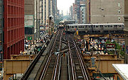
Chicago 'L'
Encyclopedia
The 'L' is the rapid transit
system serving the city of Chicago
and some of its surrounding suburbs. It is operated by the Chicago Transit Authority
(CTA). It is the second longest rapid transit system in total track mileage in the United States
, after the New York City Subway
, and is the third busiest rail mass transit system in the United States, after New York City
and Washington, DC's Metro
. Chicago's 'L' is one of four heavy-rail systems in the United States (CTA, MTA
, PATH
and the PATCO Speedline) that provides 24-hour service on at least some portions of their systems. The oldest sections of the 'L' started operating in 1892, making it the second-oldest rapid transit system in the Americas
, after New York City. The 'L' has been credited with helping create the densely built-up city core that is one of Chicago's distinguishing features. The 'L' consists of eight rapid transit lines laid out in a spoke-hub distribution paradigm
mainly focusing transit towards the Loop. Although the 'L' gained its nickname because large parts of the system are elevated
, portions of the network are in a subway, at grade level, or open cut.
On average 746,328 people ride the 'L' each weekday
, 484,420 each Saturday, and 414,512 each Sunday. Annual ridership for 2006 was 195.2 million, the highest since 1993. However, the CTA divides actual riders by roughly 1.2 to count riders who transfer between lines, putting the total number of riders at about 162.7 million. In a 2005 poll, Chicago Tribune readers voted it one of the "seven wonders of Chicago," behind the lakefront
and Wrigley Field
but ahead of Willis Tower (formerly the Sears Tower), the Water Tower
, the University of Chicago
, and the Museum of Science and Industry
.
 The first 'L', the Chicago and South Side Rapid Transit Railroad, began revenue service on June 6, 1892, when a small steam locomotive pulling four wooden coaches carrying a total of twenty seven men and three women departed the 39th Street station and arrived at the Congress Street Terminal
14 minutes later, over tracks still used by the Green Line. Over the next year service was extended to 63rd Street and Stony Island Avenue
, then the Transportation Building of the World's Columbian Exposition
in Jackson Park
.
Later in 1893 trains began running on the Lake Street Elevated Railroad
and in 1895 on the Metropolitan West Side Elevated
, which had lines to Douglas Park, Garfield Park (since replaced), Humboldt Park (since demolished), and Logan Square. The Metropolitan was the United States' first non-exhibition rapid transit system powered by electric traction motor
s, a technology whose practicality had been previously demonstrated on the "intramural railway" at the world's fair. Two years later the South Side 'L' introduced multiple-unit control
, in which several or all the cars in a train are motorized and under the control of the operator, not just the lead unit. Electrification and MU control remain standard features of most of the world's rapid transit systems.
A drawback of early 'L' service was that none of the lines entered the central business district. Instead trains dropped passengers at stub terminals on the periphery due to a state law requiring approval by neighboring property owners for tracks built over public streets, something not easily obtained downtown. This obstacle was overcome by the legendary traction magnate Charles Tyson Yerkes
, who went on to play a pivotal role in the development of the London Underground
and was immortalized by Theodore Dreiser
as the ruthless schemer Frank Cowperwood in The Titan
(1914) and other novels. Yerkes, who controlled much of the city's streetcar system, obtained the necessary signatures through cash and guile—at one point he secured a franchise to build a mile-long 'L' over Van Buren Street from Wabash Avenue to Halsted Street, extracting the requisite majority from the pliable owners on the western half of the route, then building tracks chiefly over the eastern half, where property owners had opposed him. The Union Loop opened in 1897 and greatly increased the rapid transit system's convenience. Operation on the Yerkes-owned Northwestern Elevated
, which built the North Side 'L' lines, began three years later, essentially completing the elevated infrastructure in the urban core although extensions and branches continued to be constructed in outlying areas through the 1920s.
 After 1911, the 'L' lines came under the control of Samuel Insull
, president of the Chicago Edison electric utility (now Commonwealth Edison
), whose interest stemmed initially from the fact that the trains were the city's largest consumer of electricity. Insull instituted many improvements, including free transfers and through routing, although he did not formally combine the original firms into the Chicago Rapid Transit Company
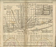
until 1924. He also bought three other Chicago electrified railroads, the Chicago North Shore and Milwaukee Railroad, Chicago Aurora and Elgin Railroad
, and South Shore interurban
lines, and ran the trains of the first two into downtown Chicago via the 'L' tracks. This period of relative prosperity ended when Insull's empire collapsed in 1932, but later in the decade the city with the help of the federal government accumulated sufficient funds to begin construction of two subway lines to supplement and, some hoped, permit eventual replacement of the Loop elevated.
The State Street subway was completed in 1943; the Dearborn subway, on which work had been suspended during World War II, opened on February 25, 1951. The subways were constructed with a secondary purpose of serving as bomb shelters, as evidenced by the close spacing of the support columns (a more extensive plan proposed replacing the entire elevated system with subways). The subways bypassed a number of tight curves and circuitous routings on the original elevated lines (Milwaukee trains, for example, originated on Chicago's northwest side but entered the Loop at the southwest corner), speeding service for many riders.
, operator of the city's streetcars. Over the next few years the CTA modernized the 'L,' replacing antiquated wooden cars with new steel ones and closing lightly used branch lines and stations, many of which had been spaced only a quarter mile apart.
Shortly after its takeover of the 'L', the CTA introduced an express service known as the A/B skip-stop service. Under this service, trains were designated as either "A" or "B" trains, and stations were alternately designated as "A" or "B", with heavily-used stations designated as "AB". "A" trains would only stop at "A" or "AB" stations, and "B" trains would only stop at "B" or "AB" stations. The system was designed to speed up lines by having trains skip stations with fewer passengers while still allowing for frequent service at the heavily-used "AB" stations. The CTA first implemented A/B skip-stop service on the Lake Street Line (now part of the Green Line) in 1948, and the service proved effective as travel times were cut by a third. By the 1950s, the service was being used throughout the system. All lines used the A/B skip-stop service between the 1950s and the 1990s with the exception of the Evanston and Skokie lines, which were too short to justify skip-stop service. Also, the Congress and Douglas branches of what later became the Blue Line were designated as "A" and "B" respectively, as were the Englewood ("A") and Jackson Park ("B") branches of what later became the Green Line, so individual stops were not skipped while trains were serving those branches. As time went by, the time periods in which skip-stop service was used were gradually decreased, as the waits at "A" and "B" stations became increasingly long during non-peak service. By the 1990s, use of the A/B skip-stop system was only justified during rush hour due to service reductions. Also another situation was that trains skipping stations to save time, could not pass the train that was directly in front of it so skipping stations was not advantageous in all regards. In 1993, the CTA began the elimination of skip-stop service when it switched the southern branches of the Red and Green Lines; after this point, Green Line trains stopped at all stations, and Red Line trains stopped at all stations south of Harrison. The elimination of A/B skip-stop service continued with the opening of the all-stop Orange Line and the conversion of the Brown Line to all-stop service. On April 28, 1995, the A/B skip-stop system was completely eliminated with the transfer of the O'Hare branch of the Blue Line and the Howard branch of the Red Line to all-stop service. The removal of skip-stop service resulted in some slight increases in travel times on some parts of the system but greatly increased ridership at former "A" and "B" stations.
The first air-conditioned cars were introduced in 1964 and the last pre-World War II cars retired in 1973. New lines were built in expressway medians. The Congress branch, built in the median of the Eisenhower Expressway, replaced the Garfield Park 'L' in 1958. The Dan Ryan branch opened on September 28, 1969, followed by an extension of the Milwaukee elevated into the Kennedy Expressway in 1970.
 Ridership had been remarkably stable for nearly 40 years after the CTA takeover despite declining mass transit usage nationwide, with an average of 594,000 riders boarding each weekday in 1960 and 577,000 in 1985. Due to the Loop Flood
in 1992, ridership was at 418,000 that year because the CTA was forced to suspend operation for several weeks in the State and Dearborn subways, used by the most heavily traveled lines.
Although ridership is healthy and growth continues, it has not been uniformly distributed. Use of North Side lines are up, while that of West Side and South Side lines are either remaining stable or seeing some declines. Ridership on the North Side Brown Line, for instance, has increased 83% since 1979, necessitating a station reconstruction project to accommodate longer trains.
 Annual traffic on the Howard branch of the Red Line, which reached 38.7 million in 2010, has exceeded the 1927 prewar peak of 38.5 million. The section of the Blue Line between the Loop and Logan Square
, which serves once-neglected but now bustling neighborhoods such as Wicker Park, Bucktown, and Palmer Square, has seen a 54% increase in weekday riders since 1992. On the other hand, weekday ridership on the South Side portion of the Green Line, which closed for two years for reconstruction starting in 1994, was 50,400 in 1978 but only 13,000 in 2006. Boardings at the 95th/Dan Ryan stop on the Red Line, though still the system's busiest at 14,100 riders per weekday, are a little over half the peak volume in the 1980s. In 1976, three North Side 'L' branches - what were then known as the Howard, Milwaukee, and Ravenswood lines − accounted for 42% of non-downtown boardings. Today (with the help of the Blue Line extension to O'Hare), they account for 58%.
The North Side (which has historically been the highest density area of the city) skew no doubt reflects the Chicago building boom of the past decade, which has focused primarily on North Side neighborhoods and downtown. It may ease somewhat in the wake of the current high level of residential construction along the south lakefront. For example, ridership at the linked Roosevelt stops on the Green, Orange, and Red Lines, which serve the burgeoning South Loop
neighborhood, has tripled since 1992, with an average of 8,000 boardings per weekday. Patronage at the Cermak-Chinatown
stop on the Red Line (4,000 weekday boardings) is at the highest level since the station opened in 1969. The 2003 Chicago Central Area Plan has proposed construction of a Green Line station at Cermak, midway between Chinatown and the McCormick Place
convention center, in expectation of continued density growth in the vicinity.
the 'L' accounted for 36% of the CTA's nearly 1.5 million weekday riders, with the remainder traveling on the extensive bus network. The rail system's ridership has increased over time. In 1926, the year of peak prewar rail usage, the 'L' carried 229 million passengers – seemingly a formidable number, but actually less than 20% of the 1.16 billion Chicago transit patrons that year, most of whom rode the city's streetcars. The shift to rail has continued in recent times. Since its low point in 1992 due to the Chicago Flood that closed subway tunnels in the downtown area, weekday 'L' ridership has increased about 25%, while bus ridership has decreased by roughly a sixth.
█ Red Line
, consisting of the Howard, State Street Subway and Dan Ryan branches
█ Blue Line
, consisting of the O'Hare, Milwaukee-Dearborn Subway, and Congress branches.
█ Brown Line
, or Ravenswood Line
█ Green Line
, consisting of the Lake Street and Englewood-Jackson Park branches
█ Orange Line
or Midway Line
█ Purple Line
, consisting of the Evanston Shuttle and Evanston Express
█ Pink Line
consisting of the Douglas Branch and Paulina Connector
█ Yellow Line
, or Skokie Swift
The Loop
s. Cars are assigned to different lines, and each line contains at most three different series of train cars. Currently, CTA operates 986 cars during peak operation periods. The oldest cars on the 'L', the 2200 series
, were built in 1969–1970, and the newest, the 3200 series
, were built in 1992–1994. The next series of train cars, the 5000 series
, will feature AC
propulsion, security cameras, and aisle-facing seating. As of February 2010, ten prototype 5000-series cars have been delivered to CTA for testing; the full order of 406 cars are expected to begin delivery starting in Fall 2010 for regular service.
All cars currently on the system utilize 600 volt
direct current
power delivered through a third rail
; the new 5000-series cars have inverters on-board to convert the DC power to AC power.
The CTA is also actively studying a number of proposals for expanding 'L' rail service, including the Circle Line and extensions to the Red, Orange, and Yellow Lines. The State's capital budget proposal for fiscal year 2010 includes funding for "preliminary engineering" on the planned Circle Line, as well as funds for modernizing and replacing the system's aging railcars.
In addition, the CTA has studied numerous other proposals for expanded rail service, some of which may be implemented in the future.
These studies are the first step in a five-step process. This process is required by the Federal New Starts program, which is an essential source of funding for the CTA’s capital expansion projects. The CTA uses a series of "Screens" to develop a "Locally Preferred Alternative," which is submitted to the federal New Starts program.
It will likely be years before any of these projects is completed; none of these projects yet has a definite source of funding.
Early conceptual planning divided the Circle Line into three segments. Phase 1 would be a restoration of the dilapidated "Paulina Connector", a short (0.75 mi/1.2 km) track segment that links Ashland/Lake with Polk. Phase 2 would link 18th on the Pink Line to Ashland on the Orange Line, with a new elevated structure running through a large industrial area. Phase 3, the final phase, would link Ashland/Lake to North/Clybourn with a new subway running through the dense neighborhoods of West Town
and Logan Square
. Although the general alignment of Phase 2 was decided upon at an early date, Phase 3 will run through dense residential areas, so the alignment must be considered carefully to avoid impacting neighborhoods adversely. CTA continues to study various possibilities for the alignment of Phase 3.
Phase 1 was completed in 2005 with the restoration of the Paulina Connector. In 2006, the Connector was soon placed into service as part of the new Pink Line. In fall 2009, CTA released the results of its Alternatives Analysis Screen 3. In it, CTA made the decision to begin early engineering work on Phase 2, due to its simple alignment through unpopulated areas and its relatively low cost (estimated at $1.1 billion). Phase 3, which CTA estimates will be far more costly due to its underground alignment, will remain under study until further notice.
Preliminary engineering work is now being performed on Phase 2. In addition to the new line, CTA plans to build four new stations as part of Phase 2, although three out of the four will be located along existing lines that the Circle Line will utilize. These will be at 18th/Clark, Cermak/Blue Island, Roosevelt/Paulina, and Congress/Paulina. 18th/Clark will be along the Orange Line in the Chinatown
neighborhood, and will include a direct transfer connection to the Cermak/Chinatown station on the Red Line. Cermak/Blue Island will be located on the newly-built elevated tracks in the Pilsen neighborhood. Roosevelt/Paulina will be located on the Pink Line in the Illinois Medical District
. Finally, Congress/Paulina will be built above the Eisenhower Expressway, with a direct transfer connection to the Illinois Medical District station on the Blue Line. Existing stations will provide service near the United Center
.
.
 Pink Line service began on June 25, 2006, though it did not involve any new track or stations. The Pink Line travels over what was formerly a branch of the Blue Line from the 54/Cermak terminal in Cicero
to the Polk-Medical Center station in Chicago. Pink Line trains then proceed via the Paulina Street Connector to the Lake Street branch of the Green Line and then clockwise around the Loop elevated via Lake-Wabash-Van Buren-Wells. (Douglas trains followed the same path between April 4, 1954 and June 22, 1958 after the old Garfield Park 'L' line was demolished to make way for the Eisenhower Expressway.) The new route, which serves 22 stations, offers more frequent service for riders on both the Congress and Douglas branches. Pink Line trains can be scheduled independently of Blue Line trains, and run more frequently than the Douglas branch of the Blue Line did.
 The Brown Line Capacity Expansion Project enabled the CTA to run eight-car trains on the Brown Line, and rebuilt stations to modern standards, including handicap accessibility. Before the project, Brown Line platforms were too short to accommodate trains longer than six cars, and increasing ridership led to uncomfortably crowded trains. After several years of construction, eight-car trains began to run at rush hour on the Brown Line in April 2008. The project reached substantial completion at the end of 2009, on time and on budget, with only minor punch list
work remaining. The project’s total cost is expected to be around $530 million.
 Numerous plans have been advanced over the years to reorganize downtown Chicago rapid transit service
, originally with the intention of replacing the Loop lines that are elevated with subways. That idea has been largely abandoned as the city seems keen on keeping an elevated/subway mix. But there have been continued calls to improve transit within the city's greatly enlarged central core. At present the 'L' does not provide direct service between the Metra commuter rail terminals in the West Loop and Michigan Avenue
, the principal shopping district, nor does it offer convenient access to popular downtown destinations such as Navy Pier
, Soldier Field
, and McCormick Place. Plans for the Central Area Circulator, a $700 million downtown light rail
system meant to remedy this, were shelved in 1995 for lack of funding. An underground line running along the lakeshore would connect some of the city's major tourist destinations, but this plan has not been widely discussed. Recognizing the cost and difficulty of implementing an all-rail solution, the Chicago Central Area Plan advocated a mix of rail and bus improvements, the centerpiece of which was the West Loop Transportation Center, a multi-level subway to be constructed under Clinton Street from Congress Parkway to Lake Street. The top level would be a pedestrian mezzanine, buses would operate in the second level, rapid transit trains in the third level, and commuter/high-speed intercity trains in the bottom level. The rapid transit level would connect to the existing Blue Line subway at its north and south ends, making possible the "Blue Line loop," envisioned as an underground counterpart to the Loop elevated. Alternatively, this level might be occupied by the Clinton Street Subway. Among other advantages, the West Loop Transportation Center would provide a direct link between the 'L' and the city's two busiest commuter rail terminals, Ogilvie Transportation Center and Union Station. The plan also proposed transitways along Carroll Avenue (a former rail right-of-way north of the main branch of the Chicago River) and under Monroe Street in the Loop, which earlier transit schemes had proposed as rail routes. The Carroll Avenue route would provide faster bus service between the commuter stations and the rapidly redeveloping Near North Side
, with possible rail service later. These new busways would tie into the bus level of the West Loop Transportation Center.
In discussing various stylings of "Loop" and "L" in Destination Loop: The Story of Rapid Transit Railroading in and around Chicago (1982), author Brian J. Cudahy quotes a passage from The Neon Wilderness (1949) by Chicago author Nelson Algren: "beneath the curved steel of the El, beneath the endless ties." Cudahy then comments, "Note that in the quotation above ... it says 'El' to mean 'elevated rapid transit railroad.' We trust that this usage can be ascribed to a publisher's editor in New York or some other east coast city; in Chicago the same expression is routinely rendered 'L.'"
While this is broadly true, it is not hard to find exceptions, such as the magazine Time Out Chicago, which refers to the system as the El and once responded to a letter on the subject by explaining that it chose "El" stylistically because it would be easier for people originally from outside of Chicago to decipher.
As used by the CTA, the name is rendered as the capital letter 'L', in quotation marks. "L" (with double quotation marks) was often used by CTA predecessors such as the Chicago Rapid Transit Company; however, the CTA uses single quotation marks (') on some printed materials and signs rather than double. In Chicago, the term subway is only applied to the sections of the 'L' network that are actually underground and is not applied to the entire system as a whole, as in New York City where both the elevated and underground portions are called the subway.
, when 4 cars of a Lake-Dan Ryan train fell from the elevated structure, killing 11, and two minor incidents in 2001, and two more in 2008, the more serious involving a Green Line train that derailed and straddled the split in the elevated structure at the 59th Street junction between the Ashland and East 63rd Street branches, and a minor one near 95th Street on the Red line.
In 2002, 25-year-old Joseph Konopka
, better known by his self-given nickname "Dr. Chaos", was arrested by Chicago Police after he was caught hoarding potassium cyanide
and sodium cyanide
in a Chicago Transit Authority storeroom in the Chicago 'L' Blue Line
subway. Konopka had picked the original locks on several doors in the tunnels, then changed the locks so that he could access the rarely used storage rooms freely.
Rapid transit
A rapid transit, underground, subway, elevated railway, metro or metropolitan railway system is an electric passenger railway in an urban area with a high capacity and frequency, and grade separation from other traffic. Rapid transit systems are typically located either in underground tunnels or on...
system serving the city of Chicago
Chicago
Chicago is the largest city in the US state of Illinois. With nearly 2.7 million residents, it is the most populous city in the Midwestern United States and the third most populous in the US, after New York City and Los Angeles...
and some of its surrounding suburbs. It is operated by the Chicago Transit Authority
Chicago Transit Authority
Chicago Transit Authority, also known as CTA, is the operator of mass transit within the City of Chicago, Illinois and some of its surrounding suburbs....
(CTA). It is the second longest rapid transit system in total track mileage in the United States
United States
The United States of America is a federal constitutional republic comprising fifty states and a federal district...
, after the New York City Subway
New York City Subway
The New York City Subway is a rapid transit system owned by the City of New York and leased to the New York City Transit Authority, a subsidiary agency of the Metropolitan Transportation Authority and also known as MTA New York City Transit...
, and is the third busiest rail mass transit system in the United States, after New York City
New York City
New York is the most populous city in the United States and the center of the New York Metropolitan Area, one of the most populous metropolitan areas in the world. New York exerts a significant impact upon global commerce, finance, media, art, fashion, research, technology, education, and...
and Washington, DC's Metro
Washington Metro
The Washington Metro, commonly called Metro, and unofficially Metrorail, is the rapid transit system in Washington, D.C., United States, and its surrounding suburbs. It is administered by the Washington Metropolitan Area Transit Authority , which also operates Metrobus service under the Metro name...
. Chicago's 'L' is one of four heavy-rail systems in the United States (CTA, MTA
Metropolitan Transportation Authority (New York)
The Metropolitan Transportation Authority of the State of New York is a public benefit corporation responsible for public transportation in the U.S...
, PATH
Port Authority Trans-Hudson
PATH, derived from Port Authority Trans-Hudson, is a rapid transit railroad linking Manhattan, New York City with Newark, Harrison, Hoboken and Jersey City in metropolitan northern New Jersey...
and the PATCO Speedline) that provides 24-hour service on at least some portions of their systems. The oldest sections of the 'L' started operating in 1892, making it the second-oldest rapid transit system in the Americas
Americas
The Americas, or America , are lands in the Western hemisphere, also known as the New World. In English, the plural form the Americas is often used to refer to the landmasses of North America and South America with their associated islands and regions, while the singular form America is primarily...
, after New York City. The 'L' has been credited with helping create the densely built-up city core that is one of Chicago's distinguishing features. The 'L' consists of eight rapid transit lines laid out in a spoke-hub distribution paradigm
Spoke-hub distribution paradigm
The hub-and-spoke distribution paradigm is a system of connections arranged like a chariot wheel, in which all traffic moves along spokes connected to the hub at the center...
mainly focusing transit towards the Loop. Although the 'L' gained its nickname because large parts of the system are elevated
Elevated railway
An elevated railway is a form of rapid transit railway with the tracks built above street level on some form of viaduct or other steel or concrete structure. The railway concerned may be constructed according to the standard gauge, narrow gauge, light rail, monorail or suspension railway system...
, portions of the network are in a subway, at grade level, or open cut.
On average 746,328 people ride the 'L' each weekday
Weekday
Weekday may either refer to only a day of the week which is part of the workweek thus not part of the weekend or to any of the days of the week.-Weekday as a day of the workweek:In most countries the days of the workweek are:# Monday# Tuesday# Wednesday...
, 484,420 each Saturday, and 414,512 each Sunday. Annual ridership for 2006 was 195.2 million, the highest since 1993. However, the CTA divides actual riders by roughly 1.2 to count riders who transfer between lines, putting the total number of riders at about 162.7 million. In a 2005 poll, Chicago Tribune readers voted it one of the "seven wonders of Chicago," behind the lakefront
Lake Michigan
Lake Michigan is one of the five Great Lakes of North America and the only one located entirely within the United States. It is the second largest of the Great Lakes by volume and the third largest by surface area, after Lake Superior and Lake Huron...
and Wrigley Field
Wrigley Field
Wrigley Field is a baseball stadium in Chicago, Illinois, United States that has served as the home ballpark of the Chicago Cubs since 1916. It was built in 1914 as Weeghman Park for the Chicago Federal League baseball team, the Chicago Whales...
but ahead of Willis Tower (formerly the Sears Tower), the Water Tower
Chicago Water Tower
The Chicago Water Tower is a contributing property in the Old Chicago Water Tower District landmark district. It is located at 806 North Michigan Avenue along the Magnificent Mile shopping district in the Near North Side community area of Chicago, Illinois...
, the University of Chicago
University of Chicago
The University of Chicago is a private research university in Chicago, Illinois, USA. It was founded by the American Baptist Education Society with a donation from oil magnate and philanthropist John D. Rockefeller and incorporated in 1890...
, and the Museum of Science and Industry
Museum of Science and Industry (Chicago)
The Museum of Science and Industry is located in Chicago, Illinois, USA in Jackson Park, in the Hyde Park neighborhood adjacent to Lake Michigan. It is housed in the former Palace of Fine Arts from the 1893 World's Columbian Exposition...
.
History
Congress Terminal
Congress Terminal was a stub-end terminal on the "L" in downtown Chicago, Illinois. It was located at Congress Parkway over Holden Court. The terminal was in operation from 1892 to 1963....
14 minutes later, over tracks still used by the Green Line. Over the next year service was extended to 63rd Street and Stony Island Avenue
Stony Island Avenue
Stony Island Avenue is a major thoroughfare on South Side of the city of Chicago, designated 1600 East in Chicago's street numbering system. It runs from 56th Street south to the Calumet River. Stony Island Avenue continues sporadically south of the Calumet in the southern suburbs, running...
, then the Transportation Building of the World's Columbian Exposition
World's Columbian Exposition
The World's Columbian Exposition was a World's Fair held in Chicago in 1893 to celebrate the 400th anniversary of Christopher Columbus's arrival in the New World in 1492. Chicago bested New York City; Washington, D.C.; and St...
in Jackson Park
Jackson Park (Chicago)
Jackson Park is a 500 acre park on Chicago's South Side, located at 6401 South Stony Island Avenue in the Woodlawn community area. It extends into the South Shore and Hyde Park community areas, bordering Lake Michigan and several South Side neighborhoods...
.
Later in 1893 trains began running on the Lake Street Elevated Railroad
Lake Street Elevated Railroad
The Lake Street Elevated Railroad was the second permanent elevated rapid transit line to be constructed in Chicago, Illinois. The first section of the line opened on November 6, 1893, and its route is still used today as part of the Green Line route of the Chicago 'L' system.-Beginnings:The Lake...
and in 1895 on the Metropolitan West Side Elevated
Metropolitan West Side Elevated Railroad
The Metropolitan West Side Elevated Railroad was the third elevated rapid transit line to be built in Chicago, Illinois and was the first of Chicago’s elevated lines to be electrically powered...
, which had lines to Douglas Park, Garfield Park (since replaced), Humboldt Park (since demolished), and Logan Square. The Metropolitan was the United States' first non-exhibition rapid transit system powered by electric traction motor
Traction motor
Traction motor refers to an electric motor providing the primary rotational torque of a machine, usually for conversion into linear motion ....
s, a technology whose practicality had been previously demonstrated on the "intramural railway" at the world's fair. Two years later the South Side 'L' introduced multiple-unit control
Multiple-unit train control
Multiple-unit train control, sometimes abbreviated to multiple-unit or MU, is a method of simultaneously controlling all the traction equipment in a train from a single location, whether it is a Multiple unit comprising a number of self-powered passenger cars or a set of locomotives.A set of...
, in which several or all the cars in a train are motorized and under the control of the operator, not just the lead unit. Electrification and MU control remain standard features of most of the world's rapid transit systems.
A drawback of early 'L' service was that none of the lines entered the central business district. Instead trains dropped passengers at stub terminals on the periphery due to a state law requiring approval by neighboring property owners for tracks built over public streets, something not easily obtained downtown. This obstacle was overcome by the legendary traction magnate Charles Tyson Yerkes
Charles Yerkes
Charles Tyson Yerkes was an American financier, born in Philadelphia. He played a major part in developing mass-transit systems in Chicago and London.-Philadelphia:...
, who went on to play a pivotal role in the development of the London Underground
London Underground
The London Underground is a rapid transit system serving a large part of Greater London and some parts of Buckinghamshire, Hertfordshire and Essex in England...
and was immortalized by Theodore Dreiser
Theodore Dreiser
Theodore Herman Albert Dreiser was an American novelist and journalist of the naturalist school. His novels often featured main characters who succeeded at their objectives despite a lack of a firm moral code, and literary situations that more closely resemble studies of nature than tales of...
as the ruthless schemer Frank Cowperwood in The Titan
The Titan
The Titan is a novel written by Theodore Dreiser in 1914. It is Dreiser's sequel to The Financier.-Plot summary:Cowperwood moves to Chicago with his new wife Aileen. He decides to take over the street-railway system. He bankrupts several opponents with the help of John J. McKenty and other...
(1914) and other novels. Yerkes, who controlled much of the city's streetcar system, obtained the necessary signatures through cash and guile—at one point he secured a franchise to build a mile-long 'L' over Van Buren Street from Wabash Avenue to Halsted Street, extracting the requisite majority from the pliable owners on the western half of the route, then building tracks chiefly over the eastern half, where property owners had opposed him. The Union Loop opened in 1897 and greatly increased the rapid transit system's convenience. Operation on the Yerkes-owned Northwestern Elevated
Northwestern Elevated Railroad
The Northwestern Elevated Railroad was the last of the privately constructed rapid transit lines to be built in Chicago, Illinois. The line ran from the Loop in downtown Chicago north to Wilson Avenue in Chicago's Uptown neighborhood a with branch to Ravenswood and Albany Park that left the main...
, which built the North Side 'L' lines, began three years later, essentially completing the elevated infrastructure in the urban core although extensions and branches continued to be constructed in outlying areas through the 1920s.
Samuel Insull
Samuel Insull was an Anglo-American innovator and investor based in Chicago who greatly contributed to creating an integrated electrical infrastructure in the United States. Insull was notable for purchasing utilities and railroads using holding companies, as well as the abuse of them...
, president of the Chicago Edison electric utility (now Commonwealth Edison
Commonwealth Edison
Commonwealth Edison is the largest electric utility in Illinois, serving the Chicago and Northern Illinois area...
), whose interest stemmed initially from the fact that the trains were the city's largest consumer of electricity. Insull instituted many improvements, including free transfers and through routing, although he did not formally combine the original firms into the Chicago Rapid Transit Company
Chicago Rapid Transit Company
The Chicago Rapid Transit Company was a privately owned firm providing rapid transit rail service in Chicago, Illinois and several adjacent communities between the years 1924 and 1947...
until 1924. He also bought three other Chicago electrified railroads, the Chicago North Shore and Milwaukee Railroad, Chicago Aurora and Elgin Railroad
Chicago Aurora and Elgin Railroad
The Chicago Aurora and Elgin Railroad , known colloquially as the "Roarin' Elgin" or the "Great Third Rail", was an interurban railroad that operated passenger and freight service on its line between Chicago, Illinois and Aurora, Batavia, Geneva, St. Charles, and Elgin. The railroad also operated...
, and South Shore interurban
Interurban
An interurban, also called a radial railway in parts of Canada, is a type of electric passenger railroad; in short a hybrid between tram and train. Interurbans enjoyed widespread popularity in the first three decades of the twentieth century in North America. Until the early 1920s, most roads were...
lines, and ran the trains of the first two into downtown Chicago via the 'L' tracks. This period of relative prosperity ended when Insull's empire collapsed in 1932, but later in the decade the city with the help of the federal government accumulated sufficient funds to begin construction of two subway lines to supplement and, some hoped, permit eventual replacement of the Loop elevated.
The State Street subway was completed in 1943; the Dearborn subway, on which work had been suspended during World War II, opened on February 25, 1951. The subways were constructed with a secondary purpose of serving as bomb shelters, as evidenced by the close spacing of the support columns (a more extensive plan proposed replacing the entire elevated system with subways). The subways bypassed a number of tight curves and circuitous routings on the original elevated lines (Milwaukee trains, for example, originated on Chicago's northwest side but entered the Loop at the southwest corner), speeding service for many riders.
CTA assumes control
By the 1940s the financial condition of the 'L,' and of Chicago mass transit in general, had become too precarious to permit continued operation without subsidies, and the necessary steps were taken to enable a public takeover. In 1947 the Chicago Transit Authority acquired the assets of the Chicago Rapid Transit Company and the Chicago Surface LinesChicago Surface Lines
The Chicago Surface Lines was operator of the street railway system of Chicago, Illinois, from the years 1913 to 1947. The firm is a predecessor of today's publicly owned operator, the Chicago Transit Authority.-History:...
, operator of the city's streetcars. Over the next few years the CTA modernized the 'L,' replacing antiquated wooden cars with new steel ones and closing lightly used branch lines and stations, many of which had been spaced only a quarter mile apart.
Shortly after its takeover of the 'L', the CTA introduced an express service known as the A/B skip-stop service. Under this service, trains were designated as either "A" or "B" trains, and stations were alternately designated as "A" or "B", with heavily-used stations designated as "AB". "A" trains would only stop at "A" or "AB" stations, and "B" trains would only stop at "B" or "AB" stations. The system was designed to speed up lines by having trains skip stations with fewer passengers while still allowing for frequent service at the heavily-used "AB" stations. The CTA first implemented A/B skip-stop service on the Lake Street Line (now part of the Green Line) in 1948, and the service proved effective as travel times were cut by a third. By the 1950s, the service was being used throughout the system. All lines used the A/B skip-stop service between the 1950s and the 1990s with the exception of the Evanston and Skokie lines, which were too short to justify skip-stop service. Also, the Congress and Douglas branches of what later became the Blue Line were designated as "A" and "B" respectively, as were the Englewood ("A") and Jackson Park ("B") branches of what later became the Green Line, so individual stops were not skipped while trains were serving those branches. As time went by, the time periods in which skip-stop service was used were gradually decreased, as the waits at "A" and "B" stations became increasingly long during non-peak service. By the 1990s, use of the A/B skip-stop system was only justified during rush hour due to service reductions. Also another situation was that trains skipping stations to save time, could not pass the train that was directly in front of it so skipping stations was not advantageous in all regards. In 1993, the CTA began the elimination of skip-stop service when it switched the southern branches of the Red and Green Lines; after this point, Green Line trains stopped at all stations, and Red Line trains stopped at all stations south of Harrison. The elimination of A/B skip-stop service continued with the opening of the all-stop Orange Line and the conversion of the Brown Line to all-stop service. On April 28, 1995, the A/B skip-stop system was completely eliminated with the transfer of the O'Hare branch of the Blue Line and the Howard branch of the Red Line to all-stop service. The removal of skip-stop service resulted in some slight increases in travel times on some parts of the system but greatly increased ridership at former "A" and "B" stations.
The first air-conditioned cars were introduced in 1964 and the last pre-World War II cars retired in 1973. New lines were built in expressway medians. The Congress branch, built in the median of the Eisenhower Expressway, replaced the Garfield Park 'L' in 1958. The Dan Ryan branch opened on September 28, 1969, followed by an extension of the Milwaukee elevated into the Kennedy Expressway in 1970.
The 'L' today
Chicago Flood
The Chicago Flood occurred on April 13, 1992, when the damaged wall of a utility tunnel beneath the Chicago River opened into a breach which flooded basements and underground facilities throughout the Chicago Loop with an estimated of water.-Cause:...
in 1992, ridership was at 418,000 that year because the CTA was forced to suspend operation for several weeks in the State and Dearborn subways, used by the most heavily traveled lines.
Although ridership is healthy and growth continues, it has not been uniformly distributed. Use of North Side lines are up, while that of West Side and South Side lines are either remaining stable or seeing some declines. Ridership on the North Side Brown Line, for instance, has increased 83% since 1979, necessitating a station reconstruction project to accommodate longer trains.
Logan Square, Chicago
Logan Square is one of the 77 city-designated community areas located on the near northwest side of the City of Chicago. The name, used here to describe the community area defined by U.S. census tracts, also applies to one of a number of smaller, more loosely defined residential neighborhoods...
, which serves once-neglected but now bustling neighborhoods such as Wicker Park, Bucktown, and Palmer Square, has seen a 54% increase in weekday riders since 1992. On the other hand, weekday ridership on the South Side portion of the Green Line, which closed for two years for reconstruction starting in 1994, was 50,400 in 1978 but only 13,000 in 2006. Boardings at the 95th/Dan Ryan stop on the Red Line, though still the system's busiest at 14,100 riders per weekday, are a little over half the peak volume in the 1980s. In 1976, three North Side 'L' branches - what were then known as the Howard, Milwaukee, and Ravenswood lines − accounted for 42% of non-downtown boardings. Today (with the help of the Blue Line extension to O'Hare), they account for 58%.
The North Side (which has historically been the highest density area of the city) skew no doubt reflects the Chicago building boom of the past decade, which has focused primarily on North Side neighborhoods and downtown. It may ease somewhat in the wake of the current high level of residential construction along the south lakefront. For example, ridership at the linked Roosevelt stops on the Green, Orange, and Red Lines, which serve the burgeoning South Loop
Near South Side, Chicago
The Near South Side is a community area of Chicago in Cook County, Illinois, United States. It is located just south of the downtown central business district, the Loop, which is itself a community area...
neighborhood, has tripled since 1992, with an average of 8,000 boardings per weekday. Patronage at the Cermak-Chinatown
Chinatown, Chicago
The Chinatown neighborhood in Chicago, Illinois, is on the South Side , centered on Cermak and Wentworth Avenues, and is an example of an American Chinatown, or ethnic-Chinese neighborhood. By the [ftp://ftp2.census.gov/census_2000/datasets/demographic_profile/Illinois/2kh17.pdf 2000 Census], has...
stop on the Red Line (4,000 weekday boardings) is at the highest level since the station opened in 1969. The 2003 Chicago Central Area Plan has proposed construction of a Green Line station at Cermak, midway between Chinatown and the McCormick Place
McCormick Place
McCormick Place is the largest convention center in the United States. It is made up of four interconnected buildings sited on and near the shore of Lake Michigan, about 4 km south of downtown Chicago, Illinois, USA. McCormick Place hosts numerous trade shows, including the Chicago Auto Show,...
convention center, in expectation of continued density growth in the vicinity.
the 'L' accounted for 36% of the CTA's nearly 1.5 million weekday riders, with the remainder traveling on the extensive bus network. The rail system's ridership has increased over time. In 1926, the year of peak prewar rail usage, the 'L' carried 229 million passengers – seemingly a formidable number, but actually less than 20% of the 1.16 billion Chicago transit patrons that year, most of whom rode the city's streetcars. The shift to rail has continued in recent times. Since its low point in 1992 due to the Chicago Flood that closed subway tunnels in the downtown area, weekday 'L' ridership has increased about 25%, while bus ridership has decreased by roughly a sixth.
Lines
Since 1993 'L' lines have been officially identified by color, although older route names survive to some extent in CTA publications and popular usage to distinguish branches of longer lines:█ Red Line
Red Line (Chicago Transit Authority)
The northern terminus of the Red Line is Howard Street in the Rogers Park neighborhood of Chicago , on the City Limits farthest north. The Red Line extends southeasterly on an elevated embankment structure about a half-mile west of the lakefront to Touhy Avenue then turns south along Glenwood...
, consisting of the Howard, State Street Subway and Dan Ryan branches
- The Red Line is the busiest route, serving an average of 266,326 passengers each weekday. It includes 33 stations on its 21.8 miles (35 km) route, traveling from Howard Street terminal on the city's northern border with EvanstonEvanston, IllinoisEvanston is a suburban municipality in Cook County, Illinois 12 miles north of downtown Chicago, bordering Chicago to the south, Skokie to the west, and Wilmette to the north, with an estimated population of 74,360 as of 2003. It is one of the North Shore communities that adjoin Lake Michigan...
, through downtown Chicago via the State Street subway, then down the Dan Ryan ExpresswayDan Ryan ExpresswayThe Dan Ryan is an expressway in the city of Chicago that runs from the Circle Interchange with I-290 near downtown Chicago through the South Side of the city. It is designated as both Interstate 94 and Interstate 90 south to 66th Street, a distance of...
median to 95th Street on the South SideRoseland, ChicagoRoseland, located on the far south side of the city, is one of the 77 official community areas of Chicago, Illinois. It includes the neighborhoods of Fernwood, Princeton Park, Lilydale, West Chesterfield, Rosemoor, Sheldon Heights and West Roseland...
. Despite its length, the Red Line stops five miles short of the city's southern border. Extension plans to 130th are currently being considered. The Red Line is one of two lines operating 24 hours a day, seven days a week and is the only transit line that goes near both Wrigley Field and U.S. Cellular FieldU.S. Cellular FieldU.S. Cellular Field is a baseball ballpark in Chicago, Illinois. Owned by the Illinois Sports Facilities Authority, it is the home of the Chicago White Sox of Major League Baseball's American League. The park opened for the 1991 season, after the White Sox had spent 81 years at old Comiskey Park...
, the homes of Chicago's Major League Baseball teams, the Chicago CubsChicago CubsThe Chicago Cubs are a professional baseball team located in Chicago, Illinois. They are members of the Central Division of Major League Baseball's National League. They are one of two Major League clubs based in Chicago . The Cubs are also one of the two remaining charter members of the National...
and Chicago White SoxChicago White SoxThe Chicago White Sox are a Major League Baseball team located in Chicago, Illinois.The White Sox play in the American League's Central Division. Since , the White Sox have played in U.S. Cellular Field, which was originally called New Comiskey Park and nicknamed The Cell by local fans...
respectively.
█ Blue Line
Blue Line (Chicago Transit Authority)
The Blue Line consists of a long trunk line in the Chicago Transit Authority's rapid transit system which extends through Chicago's Loop from O'Hare International Airport at the far northwest end of the city, through downtown via the Milwaukee-Dearborn subway, and across the West Side to its...
, consisting of the O'Hare, Milwaukee-Dearborn Subway, and Congress branches.
- The Blue Line extends from O'Hare International AirportO'Hare International AirportChicago O'Hare International Airport , also known as O'Hare Airport, O'Hare Field, Chicago Airport, Chicago International Airport, or simply O'Hare, is a major airport located in the northwestern-most corner of Chicago, Illinois, United States, northwest of the Chicago Loop...
through the Loop via the Milwaukee-Dearborn subway to the West Side. Trains travel to Des Plaines Avenue in Forest ParkForest Park, IllinoisForest Park is a village in Cook County, Illinois, a suburb of Chicago in the United States. The population was 15,688 at the 2000 census...
via the Eisenhower ExpresswayInterstate 290 (Illinois)Interstate 290 is a main Interstate freeway that runs westwards from the Chicago Loop. A portion of I-290 is officially called the Dwight D. Eisenhower Expressway. In short form, it is known as "the Ike" or the Eisenhower...
median. The route from O'Hare to Des Plaines Avenue is 26.93 miles (43 km) long. The combined number of stations is 33. Until 1970 the northern section of the Blue Line terminated at Logan Square, during which time it was called the Milwaukee route after Milwaukee AvenueMilwaukee Avenue (Chicago)Milwaukee Avenue is a major diagonal street in the city of Chicago and the northern suburbs. True to its name, it once led to the city of Milwaukee, Wisconsin. Starting with a short section at N. Canal and W. Lake Streets, it begins in earnest at the corner of N Desplaines and W. Kinzie Streets...
which ran parallel to it; in that year service was extended to Jefferson Park via the Kennedy ExpresswayKennedy ExpresswayThe John F. Kennedy Expressway is a long highway that travels northwest from the Chicago Loop to O'Hare International Airport. The expressway is named for the 35th U.S. President, John F. Kennedy. The Interstate 90 portion of the Kennedy is a part of the much longer I-90...
median, and in 1984 to O'Hare. The Blue Line is the second-busiest, with 176,377 weekday boardings. It operates 24 hours a day, 7 days a week.
█ Brown Line
Brown Line (Chicago Transit Authority)
The Brown Line starts out in northwest Chicago, at the Kimball and Lawrence Avenue terminal in Albany Park, where there is a storage yard and servicing shop for the trains to the east of the passenger station...
, or Ravenswood Line
- The Brown Line follows an 11.4 miles (18 km) route, with 19 stations between Kimball Avenue in Albany ParkAlbany Park, ChicagoAlbany Park is one of 77 well-defined Chicago, Illinois, community areas on the Northwest Side of the City of Chicago. It includes the Albany Park neighborhood, one of the most ethnically diverse in the United States...
and the Loop in downtown ChicagoChicago LoopThe Loop or Chicago Loop is one of 77 officially designated Chicago community areas located in the City of Chicago, Illinois. It is the historic commercial center of downtown Chicago...
. As of September 2011, the Brown Line has an average weekday ridership of 108,530.
█ Green Line
Green Line (Chicago Transit Authority)
The Green Line is part of the CTA rapid transit system known as the Chicago 'L'. It is the only completely elevated route in the 'L' system. It utilizes the system's oldest segments , extending with 29 stops between Forest Park and Oak Park , through Chicago's Loop, to the South Side and Englewood...
, consisting of the Lake Street and Englewood-Jackson Park branches
- A completely elevated route utilizing the system's oldest segments (dating back to 1892), the Green Line extends 20.8 miles (33.5 km) with 29 stops between Forest Park and Oak ParkOak Park, IllinoisOak Park, Illinois is a suburb bordering the west side of the city of Chicago in Cook County, Illinois, United States. It is the twenty-fifth largest municipality in Illinois. Oak Park has easy access to downtown Chicago due to public transportation such as the Chicago 'L' Blue and Green lines,...
(Harlem/Lake), through The Loop , to the South Side. South of the Garfield station the line branches, with trains alternately heading to Ashland/63rd in EnglewoodEnglewood, ChicagoEnglewood, once known as "Junction Grove" , is one of the 77 official community areas of Chicago. At its height, over 97,000 people lived in its approximately 3 square miles , but the neighborhood's population has since dropped dramatically...
and Cottage Grove/63rd in WoodlawnWoodlawn, ChicagoWoodlawn, located in the South Side of the City of Chicago, Illinois, USA, is one of 77 well defined Chicago community areas. It is bounded by Lake Michigan to the east, 60th Street to the north, Martin Luther King Drive to the west, and, mostly, 67th Street to the south...
. The East 63rd branch formerly extended to Jackson ParkJackson Park (Chicago)Jackson Park is a 500 acre park on Chicago's South Side, located at 6401 South Stony Island Avenue in the Woodlawn community area. It extends into the South Shore and Hyde Park community areas, bordering Lake Michigan and several South Side neighborhoods...
, but the portion east of Cottage Grove, which ran above 63rd Street, was demolished in stages in the 1980s and 1990s due to structural problems and then not replaced due to community demands. The average number of weekday boardings is 65,156.
█ Orange Line
Orange Line (Chicago Transit Authority)
The Orange Line, is a rapid transit line in Chicago, Illinois run by the Chicago Transit Authority as part of the 'L' system. It is approximately long, and runs below grade and elevated on existing railroad embankments and new concrete and steel structures from Chicago Midway International...
or Midway Line
- The 13 miles (21 km) long Orange Line was constructed in the early 1990s on existing railroad embankments and new concrete and steel elevated structure. It runs from a station adjacent to Chicago Midway International Airport on the Southwest Side to The Loop in downtown Chicago. Average weekday ridership is 55,787.
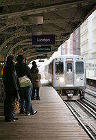
█ Purple Line
Purple Line (Chicago Transit Authority)
The Purple Line of the Chicago Transit Authority is a branch line on the northernmost section of the Chicago 'L' rapid transit network. Normally, it extends south from the Wilmette terminal at Linden Avenue, passing through Evanston to Howard Street, on Chicago's northern city limits...
, consisting of the Evanston Shuttle and Evanston Express
- The Purple Line is a 3.9 miles (6 km) branch serving north suburban Evanston and Wilmette with express service to the Loop during weekday rush hours. The local service operates from the WilmetteWilmette, IllinoisWilmette is a village in New Trier Township, Cook County, Illinois, United States. It is located north of Chicago's downtown district and has a population of 27,651. Wilmette is considered a bedroom community in the North Shore district...
terminal at Linden Avenue through Evanston to the Howard Street terminal where it connects with the Red and Yellow lines. The weekday rush hour express service continues from Howard to the Loop, running nonstop on the four-track line used by the Red Line to Belmont station, then serving all Brown Line stops to the Loop. Average weekday ridership is 9,983 on the Evanston line and 39,799 including the southern portion. The stops from Belmont to Chicago Avenue were added in the 1990s to relieve crowding on the Red and Brown lines. The name "purple line" is a reference to nearby Northwestern UniversityNorthwestern UniversityNorthwestern University is a private research university in Evanston and Chicago, Illinois, USA. Northwestern has eleven undergraduate, graduate, and professional schools offering 124 undergraduate degrees and 145 graduate and professional degrees....
, with four stops (Davis, Foster, Noyes, and Central) located just two blocks west of the University campus.
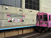
█ Pink Line
Pink Line (Chicago Transit Authority)
The Pink Line is a rapid transit line in Chicago, run by the Chicago Transit Authority as part of the Chicago 'L' system. It began operation for a 180-day trial period on June 25, 2006, running between 54th/Cermak Station in Cicero, Illinois and the Loop in downtown Chicago...
consisting of the Douglas Branch and Paulina Connector
- The Pink Line is a 11.2 miles (18 km) rerouting of former Blue Line Douglas Park branch trains from 54th/Cermak in CiceroCicero, IllinoisCicero is an incorporated town in Cook County, Illinois, United States. The population was 83,891 at the 2010 census. Cicero is named for the town of Cicero, New York, which in turn was named for Marcus Tullius Cicero, the Roman statesman and orator....
via the previously non-revenue Paulina Connector and the Green Line on Lake Street to the Loop. Its average weekday ridership is 29,242. While still an extension of the original Douglas Park branch, the line ran to Oak Park Avenue in Berwyn, four miles west of its current terminal point. In 1952 service on the extension past 54th Street was shut down and over the next decade the stations were dismantled and the tracks were either pulled up or paved over. The street level right-of-way is used to this day as a miles-long parking lot, locally known as the " 'L' Strip".
█ Yellow Line
Yellow Line (Chicago Transit Authority)
The Yellow Line, formerly known as the Skokie Swift, is part of the Chicago Transit Authority's Chicago 'L' heavy rail rapid transit system in Chicago, Illinois...
, or Skokie Swift
- The Yellow Line is a 4.7 miles (8 km) nonstop shuttle that runs from the Howard Street terminal to Skokie terminal in suburban SkokieSkokie, IllinoisSkokie is a village in Cook County, Illinois, United States. Its name comes from a Native American word for "fire". A Chicago suburb, for many years Skokie promoted itself as "The World's Largest Village". Its population, per the 2000 census, was 63,348...
. The Yellow Line is the only 'L' route that does not provide direct service to the Loop. This line was originally part of the North Shore LineChicago North Shore and Milwaukee RailroadThe Chicago North Shore and Milwaukee Railroad, often called the North Shore Line, was an interurban railroad line that operated between Chicago, Illinois, and Milwaukee, Wisconsin, until its abandonment in 1963.- Early history :...
's interurban rail service, and was acquired by the CTA in the 1960s. An infill station is currently under construction at Oakton Street which will serve downtown Skokie, and its completion (expected in January 2012) will signal the end of over 40 years of the Skokie Swift operating as a non-stop shuttle. Other plans in consideration are to extend the line from its current Dempster Street terminus to Old Orchard via an elevated right of way and the construction of an infill station in Evanston. Its average weekday ridership is 5,111.
The Loop
- Brown, Green, Orange, Pink, and Purple Line Express trains serve downtown Chicago via the Loop elevated. The Loop's nine stations average 68,554 weekday boardings.
- The Orange Line, Purple Line and the Pink Line run clockwise, the Brown Line runs counter-clockwise. The Green Line is the Loop's only through service; the other four lines circle the Loop and return to their starting points. The Loop forms a rectangle roughly 0.4 miles (650 m long) east-to-west and 0.6 miles (960 m) long north-to-south.
Rolling stock
The CTA owns 1190 train cars, permanently coupled into 595 married pairMarried pair
A twinset or twin unit is a set of two railroad cars or locomotives which are permanently coupled and treated as if they were a single unit. A twinset of cars or coaches can also be called a twin car.-USA:...
s. Cars are assigned to different lines, and each line contains at most three different series of train cars. Currently, CTA operates 986 cars during peak operation periods. The oldest cars on the 'L', the 2200 series
2200 series (Chicago 'L')
The 2200 series is a series of Chicago 'L' car built between 1969 and 1970 by the Budd Company of Philadelphia. 150 cars were built, 136 of them remain in service as of 2011....
, were built in 1969–1970, and the newest, the 3200 series
3200 series (Chicago 'L')
The 3200 series is a series of Chicago 'L' car built between 1992 and 1994 by Morrison-Knudsen. As of 2011, all of the 257 cars that were built remain in service...
, were built in 1992–1994. The next series of train cars, the 5000 series
5000 series (Chicago 'L')
The 5000 series is a series of Chicago 'L' car built by Bombardier Transportation. An $577 million order for 406 cars was placed in 2006. In July 2011, the CTA ordered 300 more cars for $331 million as an option on the first contract....
, will feature AC
Alternating current
In alternating current the movement of electric charge periodically reverses direction. In direct current , the flow of electric charge is only in one direction....
propulsion, security cameras, and aisle-facing seating. As of February 2010, ten prototype 5000-series cars have been delivered to CTA for testing; the full order of 406 cars are expected to begin delivery starting in Fall 2010 for regular service.
All cars currently on the system utilize 600 volt
Volt
The volt is the SI derived unit for electric potential, electric potential difference, and electromotive force. The volt is named in honor of the Italian physicist Alessandro Volta , who invented the voltaic pile, possibly the first chemical battery.- Definition :A single volt is defined as the...
direct current
Direct current
Direct current is the unidirectional flow of electric charge. Direct current is produced by such sources as batteries, thermocouples, solar cells, and commutator-type electric machines of the dynamo type. Direct current may flow in a conductor such as a wire, but can also flow through...
power delivered through a third rail
Third rail
A third rail is a method of providing electric power to a railway train, through a semi-continuous rigid conductor placed alongside or between the rails of a railway track. It is used typically in a mass transit or rapid transit system, which has alignments in its own corridors, fully or almost...
; the new 5000-series cars have inverters on-board to convert the DC power to AC power.
Renovation and expansion plans
The CTA’s current capital improvement spending is focused on the Brown Line Capacity Expansion Project, Slow Zone Elimination, and the rehabilitation of the Red Line. The CTA also plans to re-build the Green Line's Morgan station, and the Village of Skokie plans to rebuild the Yellow Line's Oakton station. Both stations were closed in 1948 when the CTA was created, and demolished soon after.The CTA is also actively studying a number of proposals for expanding 'L' rail service, including the Circle Line and extensions to the Red, Orange, and Yellow Lines. The State's capital budget proposal for fiscal year 2010 includes funding for "preliminary engineering" on the planned Circle Line, as well as funds for modernizing and replacing the system's aging railcars.
In addition, the CTA has studied numerous other proposals for expanded rail service, some of which may be implemented in the future.
Current capital improvements
The CTA’s Slow Zone Elimination Project will continue in 2010. In late 2007, trains were forced to operate at reduced speed over more than 22% of the system due to deteriorated track, structure, and other problems. By October 2008, system wide slow zones had been reduced to 9.1% and by January 2010, total slow zones were reduced to 6.3%.Planning future projects
All of the new rail service proposals under active consideration by the CTA are currently undergoing Alternatives Analysis Studies.These studies are the first step in a five-step process. This process is required by the Federal New Starts program, which is an essential source of funding for the CTA’s capital expansion projects. The CTA uses a series of "Screens" to develop a "Locally Preferred Alternative," which is submitted to the federal New Starts program.
It will likely be years before any of these projects is completed; none of these projects yet has a definite source of funding.
Circle Line
The proposed Circle Line would form an "outer loop," going through downtown via the State Street subway, then going southwest on the Orange Line and north along Ashland, before re-joining the subway at North/Clybourn or Clark/Division. The Circle Line would connect several different Metra lines with the 'L' system, and would facilitate transfers between existing CTA lines; these connections would be situated near the existing Metra and 'L' lines' maximum load points. CTA intitiated official "Alternatives Analysis" planning for the Circle Line in 2005.Early conceptual planning divided the Circle Line into three segments. Phase 1 would be a restoration of the dilapidated "Paulina Connector", a short (0.75 mi/1.2 km) track segment that links Ashland/Lake with Polk. Phase 2 would link 18th on the Pink Line to Ashland on the Orange Line, with a new elevated structure running through a large industrial area. Phase 3, the final phase, would link Ashland/Lake to North/Clybourn with a new subway running through the dense neighborhoods of West Town
West Town, Chicago
West Town, located in Chicago, Illinois, northwest of the Loop, is one of 77 officially designated Chicago community areas. Its name may refer to Western Avenue, which was the city's western boundary at the time of West Town's settlement, but more likely was a convenient abstraction by the creators...
and Logan Square
Logan Square, Chicago
Logan Square is one of the 77 city-designated community areas located on the near northwest side of the City of Chicago. The name, used here to describe the community area defined by U.S. census tracts, also applies to one of a number of smaller, more loosely defined residential neighborhoods...
. Although the general alignment of Phase 2 was decided upon at an early date, Phase 3 will run through dense residential areas, so the alignment must be considered carefully to avoid impacting neighborhoods adversely. CTA continues to study various possibilities for the alignment of Phase 3.
Phase 1 was completed in 2005 with the restoration of the Paulina Connector. In 2006, the Connector was soon placed into service as part of the new Pink Line. In fall 2009, CTA released the results of its Alternatives Analysis Screen 3. In it, CTA made the decision to begin early engineering work on Phase 2, due to its simple alignment through unpopulated areas and its relatively low cost (estimated at $1.1 billion). Phase 3, which CTA estimates will be far more costly due to its underground alignment, will remain under study until further notice.
Preliminary engineering work is now being performed on Phase 2. In addition to the new line, CTA plans to build four new stations as part of Phase 2, although three out of the four will be located along existing lines that the Circle Line will utilize. These will be at 18th/Clark, Cermak/Blue Island, Roosevelt/Paulina, and Congress/Paulina. 18th/Clark will be along the Orange Line in the Chinatown
Chinatown, Chicago
The Chinatown neighborhood in Chicago, Illinois, is on the South Side , centered on Cermak and Wentworth Avenues, and is an example of an American Chinatown, or ethnic-Chinese neighborhood. By the [ftp://ftp2.census.gov/census_2000/datasets/demographic_profile/Illinois/2kh17.pdf 2000 Census], has...
neighborhood, and will include a direct transfer connection to the Cermak/Chinatown station on the Red Line. Cermak/Blue Island will be located on the newly-built elevated tracks in the Pilsen neighborhood. Roosevelt/Paulina will be located on the Pink Line in the Illinois Medical District
Illinois Medical District
The Illinois Medical District is a special-use zoning district on the Near West Side of Chicago. It was designated as such by an act of the Illinois General Assembly in 1941. The District is bounded on the north by Congress Parkway, on the east by Ashland Avenue, on the west by Oakley Boulevard...
. Finally, Congress/Paulina will be built above the Eisenhower Expressway, with a direct transfer connection to the Illinois Medical District station on the Blue Line. Existing stations will provide service near the United Center
United Center
The United Center is an indoor sports arena located in Chicago. It is named after its corporate sponsor, United Airlines. The United Center is home to both the Chicago Bulls of the National Basketball Association and the Chicago Blackhawks of the National Hockey League...
.
Extensions of Red, Orange and Yellow Lines
The CTA is conducting Alternatives Analysis Studies of proposed extensions for the Red, Orange and Yellow Lines. Although these are three separate projects in three different areas of the city and suburbs, all three projects involve similar challenges of extending existing lines into underserved areas, so CTA has chosen to group the lines together into a larger program, so that analysis, engineering, and construction work can be done more cost-effectively through economies of scaleEconomies of scale
Economies of scale, in microeconomics, refers to the cost advantages that an enterprise obtains due to expansion. There are factors that cause a producer’s average cost per unit to fall as the scale of output is increased. "Economies of scale" is a long run concept and refers to reductions in unit...
.
- The Red Line Extension would provide service from the current terminus, at 95th Street, to 130th Street, decreasing transit times for residents of the far South Side and relieving crowding and congestion at the current terminus. CTA presented its locally-preferred alternative at meetings in summer 2009. This consists of a new elevated rail line between 95th St and a new terminal station at 130th, paralleling a Union Pacific railroad line through the Far South Side neighborhoods of RoselandRoseland, ChicagoRoseland, located on the far south side of the city, is one of the 77 official community areas of Chicago, Illinois. It includes the neighborhoods of Fernwood, Princeton Park, Lilydale, West Chesterfield, Rosemoor, Sheldon Heights and West Roseland...
, West PullmanWest Pullman, ChicagoWest Pullman is a neighborhood located on the far south side of the city of Chicago, Illinois. It is one of the 77 official community areas of Chicago...
, and RiverdaleRiverdale, ChicagoRiverdale, one of the 77 official community areas of Chicago, Illinois, is locatedon the city's far south side.The town of Riverdale is at the far south end of Chicago extending beyond the Chicago boundary of 138th Street to 144th Street. The town hall is at 157 West 144th Street...
. In addition to the terminal station at 130th, three new stations would be built at 103rd Street, 111th Street, and 115th Street/Michigan Avenue. Basic engineering, along with an environmental impact statement, are now underway. - The Orange Line Extension would provide transit service from the current terminus, Midway International Airport, to the Ford City Mall, which was originally meant to be the Orange Line's southern terminus when the line was planned in the 1980s. This would alleviate congestion at the current Midway terminal. CTA presented its locally-preferred alternative at meetings in summer 2009. This consists of a new elevated rail line that runs south from the Midway terminal along Belt Railway tracks, crosses Clearing Yard while heading southwest to Cicero Avenue, then runs south in the median of Cicero to a terminal on the east side of Cicero near 76th Street. Basic engineering, along with an environmental impact statement, are now underway.
- The Yellow Line Extension would provide transit service from the current terminus, at Dempster Street, to the corner of Old Orchard Road and the Edens ExpresswayEdens ExpresswayThe Edens Expressway is the main major expressway north from the city of Chicago. For most of its length, the Edens carries Interstate 94; it also carries U.S. Route 41 from Wilmette to its northern terminus. Only the short portion from the Spur Ramp to the expressway's end in Highland Park does...
, just west of the Old Orchard Shopping Center . CTA presented its locally-preferred alternative at meetings in summer 2009. This consists of a new elevated rail line from Dempster north along a former rail right-of-way to the Edens Expressway, where the line will turn to the north and run along the east side of the expressway to a terminus at Old Orchard Road. Basic engineering, along with an environmental impact statement, are now underway. Unlike extensions to the Red and Orange Lines, the Yellow Line Extension has attracted significant community opposition from residents of Skokie, as well as parents of students at Niles North High SchoolNiles North High SchoolNiles North High School, or NNHS, is a public four-year high school located in Skokie, Illinois, a North Shore suburb of Chicago, Illinois, in the United States. It is part of Niles Township Community High School District 219, which also includes Niles West High School. It is also home to several...
, whose land the new line would be constructed on. Residents and parents have cited concerns about noise, visual pollutionVisual pollutionVisual pollution is the term given to unattractive and man-made visual elements of a vista, a landscape, or any other thing that a person does not feel comfortable to look at. Visual pollution is an aesthetic issue, referring to the impacts of pollution that impair one's ability to enjoy a vista or...
, and crime. It is expected that these concerns will be addressed in the environmental impact statement.
Other recent service improvements
Cicero, Illinois
Cicero is an incorporated town in Cook County, Illinois, United States. The population was 83,891 at the 2010 census. Cicero is named for the town of Cicero, New York, which in turn was named for Marcus Tullius Cicero, the Roman statesman and orator....
to the Polk-Medical Center station in Chicago. Pink Line trains then proceed via the Paulina Street Connector to the Lake Street branch of the Green Line and then clockwise around the Loop elevated via Lake-Wabash-Van Buren-Wells. (Douglas trains followed the same path between April 4, 1954 and June 22, 1958 after the old Garfield Park 'L' line was demolished to make way for the Eisenhower Expressway.) The new route, which serves 22 stations, offers more frequent service for riders on both the Congress and Douglas branches. Pink Line trains can be scheduled independently of Blue Line trains, and run more frequently than the Douglas branch of the Blue Line did.
Punch list
A punch list is generally a list of tasks or "to-do" items. In the U.S. construction industry, a punch list is the name of a contract document used in the architecture and building trades to organize the completion of a construction project...
work remaining. The project’s total cost is expected to be around $530 million.
Possible future projects
There are other possible future expansions, identified in various city and regional planning studies. CTA has not begun official studies of these expansions, so it is unclear whether they will ever be implemented, or simply remain as visionary projects. They include:- Clinton Street Subway, running through the West Loop, connecting the Red Line near North/ClybournNorth/Clybourn (CTA)North/Clybourn is an 'L' station on the CTA's Red Line. It is a subway station with two side platforms, located at 1599 North Clybourn Avenue, in the of Near North Side neighborhood of Chicago, at the southeastern edge of the commercial Clybourn Corridor...
to the Red Line again, near Cermak-Chinatown. From North/Clybourn, the subway would run south along Larrabee Street, then under the Chicago RiverChicago RiverThe Chicago River is a system of rivers and canals with a combined length of that runs through the city of the same name, including its center . Though not especially long, the river is notable for being the reason why Chicago became an important location, as the link between the Great Lakes and...
to Clinton Street in the West Loop. Running south under Clinton, the subway would pass Ogilvie Transportation CenterOgilvie Transportation CenterThe Richard B. Ogilvie Transportation Center is a passenger terminal in downtown Chicago, Illinois, USA, serving the three commuter rail lines of Metra's Union Pacific District, which approach the terminal elevated above street level. It occupies the lower floors of the Citigroup Center...
and Union StationUnion Station (Chicago)Union Station is a major train station that opened in 1925 in Chicago, replacing an earlier 1881 station. It is now the only intercity rail terminal in Chicago, as well as being the city's primary terminal for commuter trains. The station stands on the west side of the Chicago River between Adams...
, with short connections to MetraMetraMetra is the commuter rail division of the Illinois Regional Transportation Authority. The system serves Chicago and its metropolitan area through 240 stations on 11 different rail lines. Throughout the 21st century, Metra has been the second busiest commuter rail system in the United States by...
trains. It would then continue south on Clinton until roughly 16th Street, where it would turn east, cross the river again, and rejoin the Red Line just north of the current Cermak-Chinatown stop. The estimated cost of this line was $3 billion, with no local funding source identified.
- Airport Express service to O'Hare International Airport and Midway from a downtown terminal on State StreetState Street (Chicago)State Street is a large south-north street in Chicago, Illinois, USA and its south suburbs. It begins on the Near North Side at North Avenue. For much of its course, it lies between Wabash Avenue on the east and Dearborn Street/Lafayette Avenue on the west...
. A business plan prepared for the CTA calls for a private firm to manage the venture with service starting in 2008. The project has been criticized as a boondoggle. The custom-equipped, premium-fare trains would offer nonstop service at faster speeds than the current Blue and Orange Lines. Although the trains would not run on dedicated rails (construction of such tracks could cost more than $1.5 billion), several short sections of passing track build at stations would allow the express trains to pass Blue and Orange trains while they sit at those stations. The CTA has already pledged $130 million and the city of Chicago $42 million toward the cost of the downtown station. In comments posted to her blog in 2006, CTA chair Carole Brown said, "I would support premium rail service only if it brought significant new operating dollars, capital funding, or other efficiencies to CTA … The most compelling reason to proceed with the project is the opportunity to connect the Blue and Red subway tunnels," which are one block apart downtown. In the meantime, CTA announced that due to cost overruns, it would only complete the shell of the Block 37 station; its president said "it would not make sense to completely build out the station or create the final tunnel connections until a partner is selected because final layout, technology and finishes are dependent on an operating plan."
- Mid-City TransitwayMid-City TransitwayThe Mid-City Transitway is a concept for the use of the right-of-way formerly proposed for the Crosstown Expressway in Chicago, Illinois. The uses being studied include a bus-only rapid-transit road , a truck-only bypass around the city center, or a rail rapid transit system The Mid-City...
running around, rather than through the Chicago Loop. The line would follow the Cicero Avenue/Belt Line corridor (former Crosstown Expressway alignment) between the O'Hare branch of the Blue Line at Montrose and the Dan Ryan branch of the Red Line at 87th Street. It may be an 'L' line, but busway and other options are being considered.
- Gold Line, a proposal that is unique in that it was proposed by community members and not professional transit planners. The proposal involves little to no new construction, but entails operating Metra's existing Electric LineMetra Electric LineThe Metra Electric District is an electrified commuter rail line owned and operated by Metra which connects Millennium Station in downtown Chicago, with the city's southern suburbs...
more like a rapid transit line, by running trains more frequently (every ten minutes between 6am and midnight) and providing reduced-fare transfers to CTA buses and trains. Unlike the current Metra service, which bypasses many stations to reach suburban stations more quickly, the Gold Line would make all stops within the city. The route would run along the Metra Electric Line's South Chicago Branch, running from Millennium Station in downtown southwards to a terminus at South Chicago (93rd Street). Estimates for bringing the line into operation place the cost at $160 million. Since the Gold Line was proposed, the idea of providing rapid transit service along Chicago's south lakefront has spread and gained considerable support from neighborhoods along its route. Despite its popular support, officials from CTA and Metra have largely dismissed the plan, choosing to focus on other expansion projects. In response to this and other concerns, in 2009 the RTA and the Chicago Department of Transportation authorized $450,000 for a "South Lakefront Study" that is anticipated to yield either one or two new transit projects that are eligible for Federal transit funding. This study has not yet been completed, but it may recommend a new service that is similar to the Gold Line proposal.
Chicago Central Area Transit Plan
The Chicago Central Area Transit Plan, or generally referred to as the Chicago Central Area Transit Project in the 1970s, was an extensive study of the rapid transit system in downtown Chicago; the study had begun in 1965....
, originally with the intention of replacing the Loop lines that are elevated with subways. That idea has been largely abandoned as the city seems keen on keeping an elevated/subway mix. But there have been continued calls to improve transit within the city's greatly enlarged central core. At present the 'L' does not provide direct service between the Metra commuter rail terminals in the West Loop and Michigan Avenue
Michigan Avenue (Chicago)
Michigan Avenue is a major north-south street in Chicago which runs at 100 east south of the Chicago River and at 132 East north of the river from 12628 south to 950 north in the Chicago street address system...
, the principal shopping district, nor does it offer convenient access to popular downtown destinations such as Navy Pier
Navy Pier
Navy Pier is a long pier on the Chicago shoreline of Lake Michigan. It is located in the Streeterville neighborhood of the Near North Side community area. The pier was built in 1916 at a cost of $4.5 million, equivalent to $ today. It was a part of the Plan of Chicago developed by architect and...
, Soldier Field
Soldier Field
Soldier Field is located on Lake Shore Drive in Chicago, Illinois, United States, in the Near South Side. It is home to the NFL's Chicago Bears...
, and McCormick Place. Plans for the Central Area Circulator, a $700 million downtown light rail
Light rail
Light rail or light rail transit is a form of urban rail public transportation that generally has a lower capacity and lower speed than heavy rail and metro systems, but higher capacity and higher speed than traditional street-running tram systems...
system meant to remedy this, were shelved in 1995 for lack of funding. An underground line running along the lakeshore would connect some of the city's major tourist destinations, but this plan has not been widely discussed. Recognizing the cost and difficulty of implementing an all-rail solution, the Chicago Central Area Plan advocated a mix of rail and bus improvements, the centerpiece of which was the West Loop Transportation Center, a multi-level subway to be constructed under Clinton Street from Congress Parkway to Lake Street. The top level would be a pedestrian mezzanine, buses would operate in the second level, rapid transit trains in the third level, and commuter/high-speed intercity trains in the bottom level. The rapid transit level would connect to the existing Blue Line subway at its north and south ends, making possible the "Blue Line loop," envisioned as an underground counterpart to the Loop elevated. Alternatively, this level might be occupied by the Clinton Street Subway. Among other advantages, the West Loop Transportation Center would provide a direct link between the 'L' and the city's two busiest commuter rail terminals, Ogilvie Transportation Center and Union Station. The plan also proposed transitways along Carroll Avenue (a former rail right-of-way north of the main branch of the Chicago River) and under Monroe Street in the Loop, which earlier transit schemes had proposed as rail routes. The Carroll Avenue route would provide faster bus service between the commuter stations and the rapidly redeveloping Near North Side
Near North Side, Chicago
The Near North Side is one of 77 well-defined community areas of Chicago, Illinois, United States. It is located north and east of the Chicago River, just north of the central business district . To its east is Lake Michigan and its northern boundary is the 19th-century city limit of Chicago,...
, with possible rail service later. These new busways would tie into the bus level of the West Loop Transportation Center.
'L' or El?
The Chicago rapid-transit system is officially nicknamed the 'L'. This name for the CTA rail system applies to the whole system: its elevated, subway, at-grade, and open-cut segments. The use of the nickname dates from the earliest days of the elevated railroads. Newspapers of the late 1880s referred to proposed elevated railroads in Chicago as '"L" roads.' The first route to be constructed, the Chicago and South Side Rapid Transit Railroad gained the nickname "Alley Elevated", or "Alley L" during its planning and construction, a term that was widely used by 1893, less than a year after the line opened.In discussing various stylings of "Loop" and "L" in Destination Loop: The Story of Rapid Transit Railroading in and around Chicago (1982), author Brian J. Cudahy quotes a passage from The Neon Wilderness (1949) by Chicago author Nelson Algren: "beneath the curved steel of the El, beneath the endless ties." Cudahy then comments, "Note that in the quotation above ... it says 'El' to mean 'elevated rapid transit railroad.' We trust that this usage can be ascribed to a publisher's editor in New York or some other east coast city; in Chicago the same expression is routinely rendered 'L.'"
While this is broadly true, it is not hard to find exceptions, such as the magazine Time Out Chicago, which refers to the system as the El and once responded to a letter on the subject by explaining that it chose "El" stylistically because it would be easier for people originally from outside of Chicago to decipher.
As used by the CTA, the name is rendered as the capital letter 'L', in quotation marks. "L" (with double quotation marks) was often used by CTA predecessors such as the Chicago Rapid Transit Company; however, the CTA uses single quotation marks (') on some printed materials and signs rather than double. In Chicago, the term subway is only applied to the sections of the 'L' network that are actually underground and is not applied to the entire system as a whole, as in New York City where both the elevated and underground portions are called the subway.
Security and safety
Operation of the CTA rail cars are secure and safe but in addition to general security issues on the CTA, there were calls to improve CTA's emergency response and communications procedures. The CTA has also had incidents where operators apparently overrode automatic train stops on red signals, such as the 1977 collision at Wabash and Lake1977 Chicago Loop derailment
The 1977 Chicago Loop derailment occurred on February 4, 1977, at approximately 5:25 pm, when a Chicago Transit Authority elevated train rear-ended another on the northeast corner of the Loop at Wabash Avenue and Lake Street during the evening rush hour...
, when 4 cars of a Lake-Dan Ryan train fell from the elevated structure, killing 11, and two minor incidents in 2001, and two more in 2008, the more serious involving a Green Line train that derailed and straddled the split in the elevated structure at the 59th Street junction between the Ashland and East 63rd Street branches, and a minor one near 95th Street on the Red line.
In 2002, 25-year-old Joseph Konopka
Joseph Konopka
Joseph Konopka, better known by his self-given nickname Dr. Chaos, is an American citizen who is currently serving 13 years in prison for 2 felony acts of conspiracy to commit acts of terror. In 2004, in Wisconsin, he was also charged with 6 felony counts of arson and vandalism, as well as...
, better known by his self-given nickname "Dr. Chaos", was arrested by Chicago Police after he was caught hoarding potassium cyanide
Potassium cyanide
Potassium cyanide is an inorganic compound with the formula KCN. This colorless crystalline compound, similar in appearance to sugar, is highly soluble in water. Most KCN is used in gold mining, organic synthesis, and electroplating. Smaller applications include jewelry for chemical gilding and...
and sodium cyanide
Sodium cyanide
Sodium cyanide is an inorganic compound with the formula NaCN. This highly toxic colorless salt is used mainly in gold mining but has other niche applications...
in a Chicago Transit Authority storeroom in the Chicago 'L' Blue Line
Blue Line (Chicago Transit Authority)
The Blue Line consists of a long trunk line in the Chicago Transit Authority's rapid transit system which extends through Chicago's Loop from O'Hare International Airport at the far northwest end of the city, through downtown via the Milwaukee-Dearborn subway, and across the West Side to its...
subway. Konopka had picked the original locks on several doors in the tunnels, then changed the locks so that he could access the rarely used storage rooms freely.
See also
- List of metro systems
- Mass transit in Chicago
- List of United States rapid transit systems by ridership
External links
- Chicago Transit Authority - operates CTA buses and 'L' trains
- Chicago-L.org - an unofficial, extensive fan site
- CTA Tattler - Daily blog of "L" stories
- ForgottenChicago.com - Forgotten Chicago, "Our Historic Subway Stations".
- Network map (real-distance)