
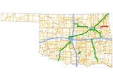
Cherokee Turnpike
Encyclopedia
Toll road
A toll road is a privately or publicly built road for which a driver pays a toll for use. Structures for which tolls are charged include toll bridges and toll tunnels. Non-toll roads are financed using other sources of revenue, most typically fuel tax or general tax funds...
in eastern Oklahoma
Oklahoma
Oklahoma is a state located in the South Central region of the United States of America. With an estimated 3,751,351 residents as of the 2010 census and a land area of 68,667 square miles , Oklahoma is the 28th most populous and 20th-largest state...
. Opened in 1991, the route is a four-lane tollway carrying US-412 from east of Kansas, Oklahoma
Kansas, Oklahoma
Kansas is a town in Delaware County, Oklahoma, United States. The population was 685 at the 2000 census.-Geography:Kansas is located at .According to the United States Census Bureau, the town has a total area of , all of it land....
to east of Chouteau
Chouteau, Oklahoma
Chouteau is the second-largest town in Mayes County, Oklahoma, United States. The population was 2,097 at the 2010 census, compared to 1,931 at the 2000 census.-Geography:Chouteau is located at ....
, and has a total length of 32.8 miles (52.8 km) and a speed limit of 75 mi/h. An alternate route, Scenic US-412, provides a free but not controlled-access route through the towns bypassed by the Turnpike with only a 55 mi/h speed limit.
Route description
The turnpike begins by branching off US-412 east of the Grand RiverGrand River (Oklahoma)
The Grand River is an alternate name for the lower section of the Neosho River, a tributary of the Arkansas River in Oklahoma. "Grand River" refers to the section of river below the confluence of the Neosho and Spring rivers in Ottawa County near Miami...
in Mayes County
Mayes County, Oklahoma
Mayes County is a county located in the U.S. state of Oklahoma. It was named for Samuel Houston Mayes, Principal Chief of the Cherokee Nation from 1895 to 1899. According to the 2010 census the population was 41,259, a 7.5 percent increase from 2000, when the population was 38,369...
. The turnpike carries US-412 for its entire length; the old alignment of US-412, which was also at one time State Highway 33
State Highway 33 (Oklahoma)
Oklahoma's State Highway 33 is a major highway that traverses most of the state, and at one time traversed the entire state. Its general orientation is west to east. All mileages listed herein are from the western terminus of the highway at the Texas state line.-Roger Mills County:SH-33 begins...
, is now Scenic US-412. The Cherokee Turnpike runs within a close distance of Scenic US-412 for its entire length. The turnpike generally varies only a few degrees from true east–west throughout its entire route.
The turnpike's first exit is a diamond interchange with State Highway 82 just south of Locust Grove
Locust Grove, Oklahoma
Locust Grove is a town in Mayes County, Oklahoma, United States. The population was 1,423 at the 2010 census compared to 1,366 at the 2000 census.-Geography:Locust Grove is located at ....
. From this point, the road travels 11 miles (17.7 km) without another exit. During this interval, the highway crosses from Mayes into Delaware County
Delaware County, Oklahoma
Delaware County is a county located in the U.S. state of Oklahoma. As of 2000, the population was 37,077 and the newest population estimate is 45,000. Its county seat is Jay. The county was named for the Delaware Indians resettled in what was then Indian Territory in the 1830s. .Delaware County...
. Just after crossing the county line, the Cherokee has its second exit, again meeting Scenic US-412 southeast of Rose
Rose, Oklahoma
Rose is a small unincorporated rural community in southeastern Mayes County, Oklahoma, United States, on Scenic U.S. Highway 412. The post office was established March 13, 1891, with David Ragsdale as the postmaster. The ZIP Code is 74364....
. This second exit is a partial cloverleaf with loop ramps in the northwest, northeast, and southwest quadrants.
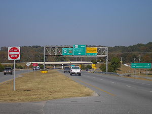
Continuing east, the turnpike's median widens to accommodate a service plaza available to both directions. After the service plaza, the turnpike passes through a barrier toll plaza. The final exit, another 11 miles (17.7 km) from the Scenic US-412 exit, occurs at US-59/SH-10, which is another diamond interchange. After this interchange Scenic US-412 crosses over the turnpike with no interchange. The median gradually widens again as Scenic US-412, now concurrent with US-59, crosses under the westbound lanes and begins running through the median. The eastbound lanes eventually merge with US-59/Scenic US-412. This marks the eastern terminus of both the Cherokee Turnpike and Scenic US-412. US-59 and mainline US-412 continue east toward West Siloam Springs, Oklahoma
West Siloam Springs, Oklahoma
West Siloam Springs is a town in Delaware County, Oklahoma, United States. The population was 877 at the 2000 census.-Geography:West Siloam Springs is located at...
, where they split, and US-412 crosses the state line into Siloam Springs, Arkansas
Siloam Springs, Arkansas
Siloam Springs is a city in Benton County, Arkansas, United States. According to 2005 Census Bureau estimates, the population of the city was 13,990...
.
History
The Cherokee Turnpike resulted from the same 1987 compromise between urban and rural legislators that resulted in the Kilpatrick, CreekCreek Turnpike
The Creek Turnpike is a partial beltway as a toll road around southern and eastern Tulsa, Oklahoma. It is long; its northern terminus is at the Will Rogers Turnpike, while the western terminus is at the Turner Turnpike...
, and Chickasaw Turnpike
Chickasaw Turnpike
The Chickasaw Turnpike is a short two-lane toll road that is located in the rural south central region of the U.S. state of Oklahoma. It stretches for from west of Sulphur to just south of Ada. The Oklahoma Turnpike Authority owns, maintains, and collects tolls on the turnpike...
s. The turnpike opened to traffic in 1991.
Services
The turnpike contains one service area, near Leach. It is located in the median between the Leach and Kansas exits, west of the toll plaza. The service plaza contains a gas station with free restrooms and a restaurant.An Oklahoma Tourism Information Center is located on the turnpike near the Kansas exit, 13 miles (20.9 km) from the Arkansas–Oklahoma state line. Free coffee is available at the tourism center.
Law enforcement along the Cherokee Turnpike is provided by Oklahoma Highway Patrol
Oklahoma Highway Patrol
The Oklahoma Highway Patrol is a major state law enforcement agency of the government of Oklahoma. It is a division of the Oklahoma Department of Public Safety. The Oklahoma Highway Patrol was legislatively created in 1937 due to the growing problem of motor vehicle accidents, the expansion of a...
Troop XD, a special troop assigned to the turnpike.
Tolls
A two-axle vehicle currently pays $2.50 ($2.40 with Pikepass) to drive the full length of the Turnpike. This is equivalent of a toll of 8¢ per mile. Drivers in vehicles with more than two axles, such as truckers, pay higher tolls.Tolls are collected for eastbound traffic upon exiting at Locust Grove and Leach, and entry at Kansas. Westbound traffic must pay toll upon exit at Kansas and entry at Leach and Locust Grove. All traffic passing through the barrier toll west of the Kansas exit must pay toll, regardless of direction.
Exit list
Exits are unnumbered.| County | Location | Mile | Destinations | Notes |
|---|---|---|---|---|
| Turnpike ends, becomes US-412 west towards Tulsa Tulsa, Oklahoma Tulsa is the second-largest city in the state of Oklahoma and 46th-largest city in the United States. With a population of 391,906 as of the 2010 census, it is the principal municipality of the Tulsa Metropolitan Area, a region with 937,478 residents in the MSA and 988,454 in the CSA. Tulsa's... |
||||
| Mayes Mayes County, Oklahoma Mayes County is a county located in the U.S. state of Oklahoma. It was named for Samuel Houston Mayes, Principal Chief of the Cherokee Nation from 1895 to 1899. According to the 2010 census the population was 41,259, a 7.5 percent increase from 2000, when the population was 38,369... |
0.0 | Eastbound exit and westbound entrance | ||
| Locust Grove Locust Grove, Oklahoma Locust Grove is a town in Mayes County, Oklahoma, United States. The population was 1,423 at the 2010 census compared to 1,366 at the 2000 census.-Geography:Locust Grove is located at .... |
~6 | |||
| Delaware Delaware County, Oklahoma Delaware County is a county located in the U.S. state of Oklahoma. As of 2000, the population was 37,077 and the newest population estimate is 45,000. Its county seat is Jay. The county was named for the Delaware Indians resettled in what was then Indian Territory in the 1830s. .Delaware County... |
~17 | |||
| Service Area | ||||
| Toll Plaza | ||||
| ~28 | ||||
| 32.9 | Westbound exit and eastbound entrance | |||
| Turnpike ends, becomes US-59/412 toward West Siloam Springs West Siloam Springs, Oklahoma West Siloam Springs is a town in Delaware County, Oklahoma, United States. The population was 877 at the 2000 census.-Geography:West Siloam Springs is located at... |
||||