

Cherangani Hills
Encyclopedia
Cherangani Hills, gently rolling slopes in the western highlands of Kenya
, are one of Kenya's five main forests. The highlands, the large central plateau, is divided by the Mau Escarpment
rising from the border with Tanzania
up to the Cherangani Hills, fencing the plateau that rises to the slopes of Mount Elgon
.
The Cherangani Hills are not of volcanic origin, unlike most of Kenya’s mountain ranges, although they are located on a forested escarpment
with shear cliff walls surrounding them on three sides.
Visible are forested ridges and stark, rocky gorges. The Cherangani Hills offer the best hill walking in Kenya for the visitor.
 The Cherangani Hills are monitored by the United Nations Environmental Programme as one of the five most important water catchment
areas in Kenya. As of the last report, monitoring the change in forestation between 2000 and 2003, the Cherangani Hills were the least affected of the forests monitored, with 174.3 hectares deforested, this loss is occurring within Marakwet District
and West Pokot District
. Since this forest cover is indigenous
, the report recommends that the area be closely watched to prevent further destruction.
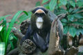
The rare De Brazza's Monkey
has been sighted here. The monkeys are confined to small areas in the Cherangani Hills that offer them little protection.
Kenya
Kenya , officially known as the Republic of Kenya, is a country in East Africa that lies on the equator, with the Indian Ocean to its south-east...
, are one of Kenya's five main forests. The highlands, the large central plateau, is divided by the Mau Escarpment
Mau Escarpment
The Mau Escarpment is a steep natural cliff approximately 3,000 m high, running along the western edge of the Great Rift Valley in Kenya.-External links:...
rising from the border with Tanzania
Tanzania
The United Republic of Tanzania is a country in East Africa bordered by Kenya and Uganda to the north, Rwanda, Burundi, and the Democratic Republic of the Congo to the west, and Zambia, Malawi, and Mozambique to the south. The country's eastern borders lie on the Indian Ocean.Tanzania is a state...
up to the Cherangani Hills, fencing the plateau that rises to the slopes of Mount Elgon
Mount Elgon
Mount Elgon is an extinct shield volcano on the border of Uganda and Kenya, north of Kisumu and west of Kitale.- Physical features :It is the oldest and largest solitary volcano in East Africa, covering an area of around 3500 km²....
.
The Cherangani Hills are not of volcanic origin, unlike most of Kenya’s mountain ranges, although they are located on a forested escarpment
Escarpment
An escarpment is a steep slope or long cliff that occurs from erosion or faulting and separates two relatively level areas of differing elevations.-Description and variants:...
with shear cliff walls surrounding them on three sides.
Visible are forested ridges and stark, rocky gorges. The Cherangani Hills offer the best hill walking in Kenya for the visitor.
Drainage basin
A drainage basin is an extent or an area of land where surface water from rain and melting snow or ice converges to a single point, usually the exit of the basin, where the waters join another waterbody, such as a river, lake, reservoir, estuary, wetland, sea, or ocean...
areas in Kenya. As of the last report, monitoring the change in forestation between 2000 and 2003, the Cherangani Hills were the least affected of the forests monitored, with 174.3 hectares deforested, this loss is occurring within Marakwet District
Marakwet District
Marakwet District is an administrative district in the Rift Valley Province of Kenya. Its capital town is Kapsowar. The district has a population of 140.629 . Local people are predominantly of the Marakwet tribe....
and West Pokot District
West Pokot District
West Pokot District is an administrative district in the Rift Valley Province of Kenya. Its capital town is Kapenguria. The district has a population of 308,086 and an area of 9,064 km² . Pokot people inhabit the area....
. Since this forest cover is indigenous
Indigenous (ecology)
In biogeography, a species is defined as native to a given region or ecosystem if its presence in that region is the result of only natural processes, with no human intervention. Every natural organism has its own natural range of distribution in which it is regarded as native...
, the report recommends that the area be closely watched to prevent further destruction.
The rare De Brazza's Monkey
De Brazza's Monkey
De Brazza's monkey is an Old World monkey endemic to the wetlands of central Africa.- Taxonomy :Locally known as swamp monkeys, these primates are named after the Italian-French explorer Pierre Savorgnan de Brazza. They were given the species name neglectus because of their skill in hiding from...
has been sighted here. The monkeys are confined to small areas in the Cherangani Hills that offer them little protection.