
Chaudière River
Encyclopedia
The Chaudière River is a 185 kilometres (115 mi) long river with its source near the Town of Lac-Mégantic
, in southeast Quebec
, Canada
. From its source Lake Megantic
in the Chaudière-Appalaches
region, it runs northwards to flow into the St. Lawrence River opposite Quebec City. The river's drainage area is 6682 square kilometres, initially in the Appalachian Mountains
, then in the low-lands of the St. Lawrence, and include 236 lakes covering 62 square kilometres and approximately 180,000 inhabitants. Its annual medium flow at the station of Saint-Lambert-de-Lauzon
is 114 m³/s, varying from 11 m³/s (low water) to 470 m³/s (spring high water), with historical maximum of 1760 m³/s.
Its principal tributaries are:
The river's basin has nearly 50% of the faunal richness of Quebec, namely 330 out of 653 vertebrate
species known in the province can be found here.
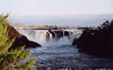
The river, and the 40 metres (131.2 ft) high Chaudière Falls which it passes over en route, are popular outdoor recreation areas.
indigenous people
resided close to the Chaudière Falls and named it “Kikonteku”, meaning “River of the Fields”. On the charts of Samuel de Champlain
, it was given the name “Etchemin River” (a name now used for another river
whose drainage area borders with that of the Chaudière River). It was called "Rivière du Sault de la Chaudière" for a period of time before it became simply "Rivière Chaudière" towards the end of the 18th century. This name refers to the waterfall
close to its mouth.
Its location was strategic for French colonization during the 18th century because the river was a natural link between New France
and the British colonies to the south. It was also used by Benedict Arnold
at the time of his 1775 expedition in the invasion of Quebec
.
In 1823, gold
was found along its shores in the Eastern Townships
of Quebec
.
area. The river impacts its industries and way of life, particularly during spring run-off, when it frequently overflows into populated areas, in spite of the 160 dams and levees. The river flows through several cities and villages of the area such as Sainte-Marie
, Saint-Georges
, Beauceville
, and Saint-Joseph-de-Beauce
.
The river is a popular location for outdoor sports, particularly at Lac-Mégantic and at Parc des Chutes-de-la-Chaudière 46°42′53.35"N 71°16′57.09"W. Located close to the mouth of the river at Lévis
, this park offers cycling and hiking trails, as well as a footbridge suspended above the river which offers a view of the waterfalls.
The falls have been harnessed for hydro-electric power since the beginning of the 20th century. The dam was rebuilt in 1999 on the remains of the old installations, and now consists of a small 24 MW power station.
Lac-Mégantic, Quebec
Lac-Mégantic is a town in Estrie on Lac Mégantic, a freshwater lake for which the town was named. Situated in the former Frontenac County in the historic Eastern Townships, Lac-Mégantic is the seat of Le Granit Regional County Municipality and of the judicial district of...
, in southeast Quebec
Quebec
Quebec or is a province in east-central Canada. It is the only Canadian province with a predominantly French-speaking population and the only one whose sole official language is French at the provincial level....
, Canada
Canada
Canada is a North American country consisting of ten provinces and three territories. Located in the northern part of the continent, it extends from the Atlantic Ocean in the east to the Pacific Ocean in the west, and northward into the Arctic Ocean...
. From its source Lake Megantic
Lake Mégantic
Lac Mégantic is a waterbody in Québec, located in the Appalachian Mountains near the U.S. border. It is a source of the Chaudière River which drains into the St Lawrence River at Québec City. The name Mégantic means 'where the fish gather' in the Abénaquis language...
in the Chaudière-Appalaches
Chaudière-Appalaches
Chaudière-Appalaches is an administrative region in Quebec, Canada. It comprises most of what is historically known as the "Beauce" |the electoral district of Beauce]]). It is named for the Chaudière River and the Appalachian Mountains....
region, it runs northwards to flow into the St. Lawrence River opposite Quebec City. The river's drainage area is 6682 square kilometres, initially in the Appalachian Mountains
Appalachian Mountains
The Appalachian Mountains #Whether the stressed vowel is or ,#Whether the "ch" is pronounced as a fricative or an affricate , and#Whether the final vowel is the monophthong or the diphthong .), often called the Appalachians, are a system of mountains in eastern North America. The Appalachians...
, then in the low-lands of the St. Lawrence, and include 236 lakes covering 62 square kilometres and approximately 180,000 inhabitants. Its annual medium flow at the station of Saint-Lambert-de-Lauzon
Saint-Lambert-de-Lauzon, Quebec
Saint-Lambert-de-Lauzon is a parish in La Nouvelle-Beauce Regional County Municipality, Quebec in Quebec, Canada. It is part of the Chaudière-Appalaches region and the population is 5,571 as of 2009. It is named after Pierre Lambert, a land surveyor who planned neighbouring Lévis...
is 114 m³/s, varying from 11 m³/s (low water) to 470 m³/s (spring high water), with historical maximum of 1760 m³/s.
Its principal tributaries are:
- Rivière du Loup (not to be confused with Rivière du LoupRivière du LoupThe Rivière du Loup is a river in southeastern Quebec which empties into the Saint Lawrence River at the city of Rivière-du-Loup, Quebec.There is a hydroelectric plant on the river near the city....
in the Bas-Saint-LaurentBas-Saint-LaurentThe Bas-Saint-Laurent region is located along the south shore of the lower Saint Lawrence River in Quebec.It has a population of 200,653 and a land area of 22,232.11 km² .-Subdivisions:...
), also known as the Rivière Linière - Famine River
- Beaurivage River
- Saint-Victor River
The river's basin has nearly 50% of the faunal richness of Quebec, namely 330 out of 653 vertebrate
Vertebrate
Vertebrates are animals that are members of the subphylum Vertebrata . Vertebrates are the largest group of chordates, with currently about 58,000 species described. Vertebrates include the jawless fishes, bony fishes, sharks and rays, amphibians, reptiles, mammals, and birds...
species known in the province can be found here.
The river, and the 40 metres (131.2 ft) high Chaudière Falls which it passes over en route, are popular outdoor recreation areas.
History
The AbenakiWestern Abenaki
The Abenaki are a tribe of Native American and First Nations people, one of the Algonquian-speaking peoples of northeastern North America. The Abenaki live in the New England region of the United States and Quebec and the Maritimes of Canada, a region called Wabanaki in the Eastern Algonquian...
indigenous people
Indigenous peoples of the Americas
The indigenous peoples of the Americas are the pre-Columbian inhabitants of North and South America, their descendants and other ethnic groups who are identified with those peoples. Indigenous peoples are known in Canada as Aboriginal peoples, and in the United States as Native Americans...
resided close to the Chaudière Falls and named it “Kikonteku”, meaning “River of the Fields”. On the charts of Samuel de Champlain
Samuel de Champlain
Samuel de Champlain , "The Father of New France", was a French navigator, cartographer, draughtsman, soldier, explorer, geographer, ethnologist, diplomat, and chronicler. He founded New France and Quebec City on July 3, 1608....
, it was given the name “Etchemin River” (a name now used for another river
Etchemin River
The Etchemin River is a river in the Chaudière-Appalaches region of eastern Quebec.It gave its name to Les Etchemins Regional County Municipality. The river itself was named for the Abenaki native people of the area who the French called "les Etchemins"...
whose drainage area borders with that of the Chaudière River). It was called "Rivière du Sault de la Chaudière" for a period of time before it became simply "Rivière Chaudière" towards the end of the 18th century. This name refers to the waterfall
Waterfall
A waterfall is a place where flowing water rapidly drops in elevation as it flows over a steep region or a cliff.-Formation:Waterfalls are commonly formed when a river is young. At these times the channel is often narrow and deep. When the river courses over resistant bedrock, erosion happens...
close to its mouth.
Its location was strategic for French colonization during the 18th century because the river was a natural link between New France
New France
New France was the area colonized by France in North America during a period beginning with the exploration of the Saint Lawrence River by Jacques Cartier in 1534 and ending with the cession of New France to Spain and Great Britain in 1763...
and the British colonies to the south. It was also used by Benedict Arnold
Benedict Arnold
Benedict Arnold V was a general during the American Revolutionary War. He began the war in the Continental Army but later defected to the British Army. While a general on the American side, he obtained command of the fort at West Point, New York, and plotted to surrender it to the British forces...
at the time of his 1775 expedition in the invasion of Quebec
Invasion of Canada (1775)
The Invasion of Canada in 1775 was the first major military initiative by the newly formed Continental Army during the American Revolutionary War. The objective of the campaign was to gain military control of the British Province of Quebec, and convince the French-speaking Canadiens to join the...
.
In 1823, gold
Gold
Gold is a chemical element with the symbol Au and an atomic number of 79. Gold is a dense, soft, shiny, malleable and ductile metal. Pure gold has a bright yellow color and luster traditionally considered attractive, which it maintains without oxidizing in air or water. Chemically, gold is a...
was found along its shores in the Eastern Townships
Eastern Townships
The Eastern Townships is a tourist region and a former administrative region in south-eastern Quebec, lying between the former seigneuries south of the Saint Lawrence River and the United States border. Its northern boundary roughly followed Logan's Line, the geologic boundary between the flat,...
of Quebec
Quebec
Quebec or is a province in east-central Canada. It is the only Canadian province with a predominantly French-speaking population and the only one whose sole official language is French at the provincial level....
.
The river today
The Chaudière valley mostly crosses the BeauceBeauce, Quebec
Beauce is a historical and traditional region of Quebec located south of Quebec City. It corresponds approximately to the regional county municipalities of Beauce-Sartigan, Robert-Cliche and La Nouvelle-Beauce, and its major communities are Saint-Georges, Sainte-Marie, Beauceville,...
area. The river impacts its industries and way of life, particularly during spring run-off, when it frequently overflows into populated areas, in spite of the 160 dams and levees. The river flows through several cities and villages of the area such as Sainte-Marie
Sainte-Marie, Quebec
-References:**- External links :*...
, Saint-Georges
Saint-Georges, Quebec
Saint-Georges is a city in the province of Quebec. It is the seat of Beauce-Sartigan Regional County Municipality, part of the Chaudière-Appalaches region. The population was 30,113 as of 2009. Route 173 runs through Saint-Georges Est and heads south to the border with Maine, USA...
, Beauceville
Beauceville, Quebec
Beauceville is a city in and the seat of the Municipalité régionale de comté Robert-Cliche in Quebec, Canada. It is part of the Chaudière-Appalaches region and the population was 6,226 as of the Canada 2006 Census....
, and Saint-Joseph-de-Beauce
Saint-Joseph-de-Beauce, Quebec
Saint-Joseph-de-Beauce is a city in the Municipalité régionale de comté Robert-Cliche in Quebec, Canada. It is part of the Chaudière-Appalaches region and the population is 4,490 as of 2009....
.
The river is a popular location for outdoor sports, particularly at Lac-Mégantic and at Parc des Chutes-de-la-Chaudière 46°42′53.35"N 71°16′57.09"W. Located close to the mouth of the river at Lévis
Lévis, Quebec
Lévis is a city in eastern Quebec, Canada. It is located on the south shore of the St. Lawrence River, opposite Quebec City. A ferry links Old Quebec with Old Lévis, and two bridges, the Quebec Bridge and the Pierre Laporte Bridge, connect western Lévis with Quebec City. The Société de transport de...
, this park offers cycling and hiking trails, as well as a footbridge suspended above the river which offers a view of the waterfalls.
The falls have been harnessed for hydro-electric power since the beginning of the 20th century. The dam was rebuilt in 1999 on the remains of the old installations, and now consists of a small 24 MW power station.