

Chad Basin National Park
Encyclopedia
The Chad Basin National Park is a national park in northeastern Nigeria
, with a total area of about 2,258 km².
The park is fragmented, with three sectors.
The Chingurmi-Duguma sector is in Borno State
, in a Sudanian Savanna
ecological zone.
The Bade-Nguru Wetlands and Bulatura sectors are in Yobe State
in the Sahel
ecological zone.
As of 1999 it had not been surveyed, so the boundaries are not well-established.
The park is used by many farmers, grazers and fishermen.
Despite significant investment in lodgings for tourists, the park sectors only attract a few hundred visitors each year due to the lack of spectacular wildlife.
By 2008, staff at the park office in Maiduguri
knew little about the park, the lodgings had been abandoned, and tourists visiting the park sectors had to take off-road vehicles and be prepared to camp out.
 The Chingurmi-Duguma sector is in the Bama
Local Government Area of Borno State, adjoining the Waza National Park
in the Republic of Cameroon, around coordinates 11°45′0"N 14°15′0"E.
It has an area of 1,228 km2, with a stratified topology.
The northern part is within the Sahel zone while southern sector has a typical Sudan–Guinea Savanna ecology, and includes Acacia
-Balanites
woodlands separated by dense stands of Elephant grass and Sorghum
.
Waters from the Dorma river flood much of the sector in the rainy season, creating flood-plain wetlands that attract waterbirds and other wildlife.
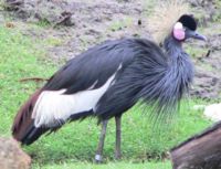
The resident Black Crowned Crane (Balearica pavonina) is abundant, but is considered vulnerable.
The Helmeted Guineafowl (Numida meleagris) is also abundant.
Demoiselle Cranes (Grus virgo) visit in the winter, as well as large numbers of White Storks (Ciconia ciconia).
A 2007 report estimated that there were about 100 elephants in the sector, which may still migrate to and from the Waza park.
The Cameroon and Nigerian park authorities have been cooperating to prevent poaching of wildlife and to raise awareness among the local people of the longer-term value of conservation.
There have been discussions by the IUCN over making the sector and the Waza National Park an internationally designated protected area
.
, and has an area of 938 km2 around coordinates 12°40′0"N 10°30′0"E.
It lies in the southwest of the Bade
and Jakusko
Local Government Areas of Yobe State.
The sector includes the Dagona Waterfowl Sanctuary, an important resting place for migratory birds.
It also includes five forest reserves.
Annual rainfall ranges between 200-600 mm, during the period late May-September.
With reduced flooding due to upstream dams and perhaps climate change, and with increasing population, the environment is degrading. There is growing competition between humans and wildlife. Farmers set out poison to kill the crop-destroying Quelea quelea, in the process killing non-target species. Marginal land is now coming under cultivation and tree cover in the forest reserves is being depleted.
Local Government Area of Yobe State, and has an area of 92 km2 around coordinates 13°15′0"N 11°00′0"E.
The sector has a series of swampy valleys separated by scenic sand dunes. The valleys contain rich deposits of potash
.
Nigeria
Nigeria , officially the Federal Republic of Nigeria, is a federal constitutional republic comprising 36 states and its Federal Capital Territory, Abuja. The country is located in West Africa and shares land borders with the Republic of Benin in the west, Chad and Cameroon in the east, and Niger in...
, with a total area of about 2,258 km².
The park is fragmented, with three sectors.
The Chingurmi-Duguma sector is in Borno State
Borno State
Borno State is a state in north-eastern Nigeria. Its capital is Maiduguri. The state was formed in 1976 from the split of the North-Eastern State...
, in a Sudanian Savanna
Sudanian Savanna
The Sudanian Savanna is a broad belt of tropical savanna that runs east and west across the African continent, from the Atlantic Ocean in the west to the Ethiopian Highlands in the east. The Sahel, a belt of drier grasslands and acacia savannas, lies to the north, between the Sudanian Savanna and...
ecological zone.
The Bade-Nguru Wetlands and Bulatura sectors are in Yobe State
Yobe State
Yobe State is a state located in Northern Nigeria. A mainly agricultural state, it was created on August 27, 1991. Yobe state was carved out of present-day Borno State. The capital of Yobe state is Damaturu.-Geography:...
in the Sahel
Sahel
The Sahel is the ecoclimatic and biogeographic zone of transition between the Sahara desert in the North and the Sudanian Savannas in the south.It stretches across the North African continent between the Atlantic Ocean and the Red Sea....
ecological zone.
Status
The park combines the former Chingurmi-Dugoma Game Reserve, Gorgoram and Zurgun Baneri Forest Reserves, and Bulature Oasis.As of 1999 it had not been surveyed, so the boundaries are not well-established.
The park is used by many farmers, grazers and fishermen.
Despite significant investment in lodgings for tourists, the park sectors only attract a few hundred visitors each year due to the lack of spectacular wildlife.
By 2008, staff at the park office in Maiduguri
Maiduguri
Maiduguri, also fondly called Yerwa by its locals, is the capital and the largest city of Borno State in north-eastern Nigeria. The city sits along the seasonal Ngadda River which disappears into the Firki swamps in the areas around Lake Chad...
knew little about the park, the lodgings had been abandoned, and tourists visiting the park sectors had to take off-road vehicles and be prepared to camp out.
Chingurmi-Duguma sector
Bama, Nigeria
Bama is a Local Government Area of Borno State, Nigeria. Its headquarters are in the town of Bama.It has an area of 4,997 km² and a population of 269,986 at the 2006 census.The postal code of the area is 610....
Local Government Area of Borno State, adjoining the Waza National Park
Waza National Park
Waza National Park is a national park in Far North Province, Cameroon. It was founded in 1934, albeit as a hunting reserve, and covers a total of 1,700 km²...
in the Republic of Cameroon, around coordinates 11°45′0"N 14°15′0"E.
It has an area of 1,228 km2, with a stratified topology.
The northern part is within the Sahel zone while southern sector has a typical Sudan–Guinea Savanna ecology, and includes Acacia
Acacia
Acacia is a genus of shrubs and trees belonging to the subfamily Mimosoideae of the family Fabaceae, first described in Africa by the Swedish botanist Carl Linnaeus in 1773. Many non-Australian species tend to be thorny, whereas the majority of Australian acacias are not...
-Balanites
Balanites
Balanites is a genus of flowering plants in the caltrop family, Zygophyllaceae.-Selected species:* Balanites aegyptiaca Delile* Balanites maughamii Sprague* Balanites roxburghii Planch.-External links:...
woodlands separated by dense stands of Elephant grass and Sorghum
Sorghum
Sorghum is a genus of numerous species of grasses, one of which is raised for grain and many of which are used as fodder plants either cultivated or as part of pasture. The plants are cultivated in warmer climates worldwide. Species are native to tropical and subtropical regions of all continents...
.
Waters from the Dorma river flood much of the sector in the rainy season, creating flood-plain wetlands that attract waterbirds and other wildlife.
The resident Black Crowned Crane (Balearica pavonina) is abundant, but is considered vulnerable.
The Helmeted Guineafowl (Numida meleagris) is also abundant.
Demoiselle Cranes (Grus virgo) visit in the winter, as well as large numbers of White Storks (Ciconia ciconia).
A 2007 report estimated that there were about 100 elephants in the sector, which may still migrate to and from the Waza park.
The Cameroon and Nigerian park authorities have been cooperating to prevent poaching of wildlife and to raise awareness among the local people of the longer-term value of conservation.
There have been discussions by the IUCN over making the sector and the Waza National Park an internationally designated protected area
Protected area
Protected areas are locations which receive protection because of their recognised natural, ecological and/or cultural values. There are several kinds of protected areas, which vary by level of protection depending on the enabling laws of each country or the regulations of the international...
.
Bade-Nguru Wetlands sector
The Bade-Nguru Wetlands sector is part of the Hadejia-Nguru wetlandsHadejia-Nguru wetlands
thumb|right|300px|[[Yobe River]] catchment area showing location of the Hadejia-Nguru wetlandsThe Hadejia-Nguru wetlands in Yobe State in northern Nigeria, which include Nguru Lake, are ecologically and economically important...
, and has an area of 938 km2 around coordinates 12°40′0"N 10°30′0"E.
It lies in the southwest of the Bade
Bade, Nigeria
Bade is a Local Government Area in Yobe State, Nigeria. Its headquarters are in the town of Gashua.It has an area of 772 km² and a population of 139,782 at the 2006 census.The postal code of the area is 631....
and Jakusko
Jakusko
Jakusko is a Local Government Area in Yobe State, Nigeria. Its headquarters are in the town of Jakusko in the west of the area at.It has an area of 3,941 km² and a population of 229,083 at the 2006 census.The postal code of the area is 631....
Local Government Areas of Yobe State.
The sector includes the Dagona Waterfowl Sanctuary, an important resting place for migratory birds.
It also includes five forest reserves.
Annual rainfall ranges between 200-600 mm, during the period late May-September.
With reduced flooding due to upstream dams and perhaps climate change, and with increasing population, the environment is degrading. There is growing competition between humans and wildlife. Farmers set out poison to kill the crop-destroying Quelea quelea, in the process killing non-target species. Marginal land is now coming under cultivation and tree cover in the forest reserves is being depleted.
Bulatura sector
The Bulatura sector is in the YusufariYusufari
Yusufari is a Local Government Area in Yobe State, Nigeria. Its headquarters are in the town of Yusufari in the south-east of the area at. It shares a border in the north with The Republic of Niger....
Local Government Area of Yobe State, and has an area of 92 km2 around coordinates 13°15′0"N 11°00′0"E.
The sector has a series of swampy valleys separated by scenic sand dunes. The valleys contain rich deposits of potash
Potash
Potash is the common name for various mined and manufactured salts that contain potassium in water-soluble form. In some rare cases, potash can be formed with traces of organic materials such as plant remains, and this was the major historical source for it before the industrial era...
.