
Cervený Kláštor
Encyclopedia
This is an article about the Slovakian village. For the monastery see, Červený Kláštor (Monastery)
Červený Kláštor is a small village
and municipality
in the far north Kežmarok District
in the Prešov Region
of northern Slovakia
, near the Polish border in the Zamagurie
region.
Monastery was established on this location, than part of the Habsburg-ruled Kingdom of Hungary
, in 1710.
In 1782 it was secularized as part of Emperor Joseph II
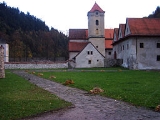
's campaign against monastic orders that in his view didn't pursue useful activities. The monastery building still exists, however (see photo).
The present village was founded in 1828.
lies at an altitude
of 465 metres and covers an area
of 3.043 km².
It has a population
of about 222 people. It lies 8 km east of the centre of Zamagurie region, Spišská Stará Ves. The governing body of the Pieniny national park
is located in the village.
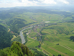
Dunajec river, which makes border with Poland, flows near the village. It is used for tourist purposes for rafting. Other attractions in or near the village include the Červený kláštor (spelled with a lower-case "k"; literally Red Monastery) or walking in the surrounding mountains of Pieniny
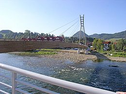
. Since 2006, there is a new bridge for pedestrians in operation, connecting Červený Kláštor and Sromowce Niżne
.
Červený Kláštor (Monastery)
Červený Kláštor is a medieval monastery located in Slovakia. It is located in the village of Červený Kláštor within the Pieniny Mountains, next to the Dunajec River.-Carthusian Period:...
Červený Kláštor is a small village
Village
A village is a clustered human settlement or community, larger than a hamlet with the population ranging from a few hundred to a few thousand , Though often located in rural areas, the term urban village is also applied to certain urban neighbourhoods, such as the West Village in Manhattan, New...
and municipality
Municipality
A municipality is essentially an urban administrative division having corporate status and usually powers of self-government. It can also be used to mean the governing body of a municipality. A municipality is a general-purpose administrative subdivision, as opposed to a special-purpose district...
in the far north Kežmarok District
Kežmarok District
Kežmarok District is a district inthe Prešov Region of eastern Slovakia.Until 1918, the district was almost entirely part of the Hungarian county of Spiš, apart from a small area in the...
in the Prešov Region
Prešov Region
The Prešov Region is one of the eight Slovak administrative regions. It consists of 13 districts.-Geography:It is located in north-eastern Slovakia and has an area of 8,975 km². The region has diverse types of landscapes occurring in Slovakia, but mostly highlands and hilly lands dominate the...
of northern Slovakia
Slovakia
The Slovak Republic is a landlocked state in Central Europe. It has a population of over five million and an area of about . Slovakia is bordered by the Czech Republic and Austria to the west, Poland to the north, Ukraine to the east and Hungary to the south...
, near the Polish border in the Zamagurie
Zamagurie
Zamagurie is an area in the north of the Spiš region, between the Spišská Magura in the south, Dunajec river in the north and Białka river in the west...
region.
History
A CamaldoleseCamaldolese
The Camaldolese monks and nuns are part of the Benedictine family of monastic communities which follow the way of life outlined in the Rule of St. Benedict, written in the 6th century...
Monastery was established on this location, than part of the Habsburg-ruled Kingdom of Hungary
Kingdom of Hungary
The Kingdom of Hungary comprised present-day Hungary, Slovakia and Croatia , Transylvania , Carpatho Ruthenia , Vojvodina , Burgenland , and other smaller territories surrounding present-day Hungary's borders...
, in 1710.
In 1782 it was secularized as part of Emperor Joseph II
Joseph II, Holy Roman Emperor
Joseph II was Holy Roman Emperor from 1765 to 1790 and ruler of the Habsburg lands from 1780 to 1790. He was the eldest son of Empress Maria Theresa and her husband, Francis I...
's campaign against monastic orders that in his view didn't pursue useful activities. The monastery building still exists, however (see photo).
The present village was founded in 1828.
Geography
The municipalityMunicipality
A municipality is essentially an urban administrative division having corporate status and usually powers of self-government. It can also be used to mean the governing body of a municipality. A municipality is a general-purpose administrative subdivision, as opposed to a special-purpose district...
lies at an altitude
Altitude
Altitude or height is defined based on the context in which it is used . As a general definition, altitude is a distance measurement, usually in the vertical or "up" direction, between a reference datum and a point or object. The reference datum also often varies according to the context...
of 465 metres and covers an area
Area
Area is a quantity that expresses the extent of a two-dimensional surface or shape in the plane. Area can be understood as the amount of material with a given thickness that would be necessary to fashion a model of the shape, or the amount of paint necessary to cover the surface with a single coat...
of 3.043 km².
It has a population
Population
A population is all the organisms that both belong to the same group or species and live in the same geographical area. The area that is used to define a sexual population is such that inter-breeding is possible between any pair within the area and more probable than cross-breeding with individuals...
of about 222 people. It lies 8 km east of the centre of Zamagurie region, Spišská Stará Ves. The governing body of the Pieniny national park
Pieniny National Park (Slovakia)
Pieniny National Park is a national park in northern Slovakia. The park is located in the western Pieniny Mountains on the border with Poland. It is the smallest national park in Slovakia with an area of 37.5 km² and its buffer zone covers an area of 224.44 km² .It lies in the districts of...
is located in the village.
Dunajec river, which makes border with Poland, flows near the village. It is used for tourist purposes for rafting. Other attractions in or near the village include the Červený kláštor (spelled with a lower-case "k"; literally Red Monastery) or walking in the surrounding mountains of Pieniny
Pieniny
Pieniny is a mountain range in the south of Poland and the north of Slovakia.The Pieniny mountain range is divided into three parts – Pieniny Spiskie and Pieniny Właściwe in Poland; and, Malé Pieniny in Slovakia. The Pieniny mountains consist mainly of the limestone and dolomite rock strata...
. Since 2006, there is a new bridge for pedestrians in operation, connecting Červený Kláštor and Sromowce Niżne
Sromowce Nizne
Sromowce Niżne is a village in the administrative district of Gmina Czorsztyn, within Nowy Targ County, Lesser Poland Voivodeship, in southern Poland, close to the border with Slovakia. It lies approximately south-east of Maniowy, east of Nowy Targ, and south-east of the regional capital...
.
External links