
Cedarville, California
Encyclopedia
Cedarville is a census-designated place
in Modoc County
, California
. It is located 20 miles (32 km) east of Alturas
, at an elevation of 4652 feet (1418 m).
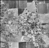
By 1880 Cedarville was the largest town in the valley, with a population of around 220. The town has grown little in the following hundred years; however, as of the 2010 census, the population was 514.
The ZIP code
for Cedarville is 96104. Wired telephone numbers in Cedarville follow the format (530
) 279-2xxx or 279-6xxx. Wired telephone service is provided by Frontier Communications. Cedarville Hospital, operated by the Surprise Valley Hospital District, is located on Main Street at Washington. Cedarville Airport
is located along Surprise Valley Road 1.5 miles (2.4 km) north of State Route 299.
The town hosts an annual Last Frontier Fair. Tourist services, such as bed and breakfast accommodations, are available in the community. An area attraction is the Warner Mountains, most of which are inside Modoc National Forest.
Surprise Valley offers hiking, fishing, birding, skiing, hunting, petroglyphs, photography, pioneer history and scenery.
According to the United States Census Bureau
, the CDP covers an area of 5.4 square miles (14.1 km²), 99.92% of it land, and 0.08% of it water.
The town is the largest in Surprise Valley, and is located on the alluvial apron at the mouth of Cedar Canyon, at the eastern base of the Warner Mountains, near the western shore of Middle Alkali Lake.
. The inventor of aerogel
, Steven Kistler
, was born in the town in 1900. A 1913 book described Cedarville as being on Middle Alkali Lake and having a population of about 500.
Originally known as Deep Creek, Cedarville was founded in about 1864 as a stopping place for wagon train
s. In 1867 a trading post
was being run by William Cressler and John Bonner, who later also built the first road over Cedar Pass, connecting Surprise Valley to Alturas
and the rest of Modoc County. The Laxague Lumber Company mill was located in Cedarville, and employed from 18 to 60 residents.
As branch county seat of Siskiyou County, nearby Lake City
was the dominant population center of Surprise Valley until Modoc County formed in 1874. However, by 1880 Cedarville was the largest in the valley, with a population of around 220, and once Fort Bidwell, 20 miles (32.2 km) to the north was demilitarized, Cedarville's central location and access to Cedar Pass made it the natural population and business center of the valley. However, Cedarville has grown little in the following hundred years.
was 94.4 people per square mile (36.4/km²). The racial makeup of Cedarville was 422 (82.1%) White, 1 (0.2%) African American, 15 (2.9%) Native American, 0 (0.0%) Asian, 0 (0.0%) Pacific Islander, 59 (11.5%) from other races
, and 17 (3.3%) from two or more races. Hispanic or Latino of any race were 86 persons (16.7%).
The Census reported that 490 people (95.3% of the population) lived in households, 2 (0.4%) lived in non-institutionalized group quarters, and 22 (4.3%) were institutionalized.
There were 237 households, out of which 55 (23.2%) had children under the age of 18 living in them, 98 (41.4%) were opposite-sex married couples
living together, 21 (8.9%) had a female householder with no husband present, 13 (5.5%) had a male householder with no wife present. There were 19 (8.0%) unmarried opposite-sex partnerships
, and 1 (0.4%) same-sex married couples or partnerships. 92 households (38.8%) were made up of individuals and 51 (21.5%) had someone living alone who was 65 years of age or older. The average household size was 2.07. There were 132 families
(55.7% of all households); the average family size was 2.71.
The population was spread out with 94 people (18.3%) under the age of 18, 31 people (6.0%) aged 18 to 24, 104 people (20.2%) aged 25 to 44, 149 people (29.0%) aged 45 to 64, and 136 people (26.5%) who were 65 years of age or older. The median age was 49.5 years. For every 100 females there were 89.0 males. For every 100 females age 18 and over, there were 94.4 males.
There were 294 housing units at an average density of 54.0 per square mile (20.8/km²), of which 146 (61.6%) were owner-occupied, and 91 (38.4%) were occupied by renters. The homeowner vacancy rate was 1.3%; the rental vacancy rate was 12.5%. 296 people (57.6% of the population) lived in owner-occupied housing units and 194 people (37.7%) lived in rental housing units.
called Cedarville, but it did define a Zip Code Tabulation Area
(ZCTA), 96104. Because Cedarville is contained within this ZCTA, it is possible to obtain Census data from the United States 2000 Census for the area even though data for "Cedarville" is unavailable.
As of the census
of 2000, there were 849 people, 381 households, and 249 families residing in the ZCTA of 96104. The population density
was 3.2 per sq mi. There were 457 housing units at an average density of 1.6 per square mile. The racial makeup of the city was 92.8% White, 0.0% African American, 3.4% Native American, 1.3% Asian, 0.0% Pacific Islander, 1.1% from other races, and 1.4% from two or more races. 6.8% of the population were Hispanic or Latino of any race.
There were 381 households out of which 22.3% had children under the age of 18 living with them, 53.3% were married couples living together, 2.4% had a female householder with no husband present, and 34.6% were non-families. 29.9% of all households were made up of individuals. The average household size was 2.17.
In the town the population was spread out with 21.6% under the age of 18, 5.1% from 18 to 24, 19.7% from 25 to 44, 29.9% from 45 to 64, and 23.7% who are 65 years of age or older. For every 100 females there are 98.4 males.
The median income for a household in the town was $32,159, and the median income for a family was $36,938. Males had a median income of $37,136 versus $19,083 for females. The per capita income for the town was $20,412. 18.5% of the population and 14.1% of families were below the poverty line.
Cedarville is located in the 1st Senate
District, represented by Republican
Dave Cox
, and in the 2nd Assembly
District, represented by Republican Jim Nielsen
. Federally, Cedarville is located in California's 4th congressional district
, which has a Cook PVI
of R +11 and is represented by Republican Tom McClintock
.
Census-designated place
A census-designated place is a concentration of population identified by the United States Census Bureau for statistical purposes. CDPs are delineated for each decennial census as the statistical counterparts of incorporated places such as cities, towns and villages...
in Modoc County
Modoc County, California
Modoc County is a county located in the far northeast corner of the U.S. state of California, bounded by the state of Oregon to the north and the state of Nevada to the east. As of the 2010 census, its population was 9,686, up from 9,449 at the 2000 census. The current county seat is Alturas, the...
, California
California
California is a state located on the West Coast of the United States. It is by far the most populous U.S. state, and the third-largest by land area...
. It is located 20 miles (32 km) east of Alturas
Alturas, California
Alturas is the county seat of Modoc County, California, United States. Alturas is located on the Pit River, east of the center of Modoc County, at an elevation of 4370 feet...
, at an elevation of 4652 feet (1418 m).
By 1880 Cedarville was the largest town in the valley, with a population of around 220. The town has grown little in the following hundred years; however, as of the 2010 census, the population was 514.
The ZIP code
ZIP Code
ZIP codes are a system of postal codes used by the United States Postal Service since 1963. The term ZIP, an acronym for Zone Improvement Plan, is properly written in capital letters and was chosen to suggest that the mail travels more efficiently, and therefore more quickly, when senders use the...
for Cedarville is 96104. Wired telephone numbers in Cedarville follow the format (530
Area code 530
North American area code 530 is a California telephone area code that covers Auburn, Chico, Colfax, Davis, Grass Valley, Marysville, Oroville, Placerville, Redding, Red Bluff, Susanville, Truckee, Woodland, Yuba City and South Lake Tahoe....
) 279-2xxx or 279-6xxx. Wired telephone service is provided by Frontier Communications. Cedarville Hospital, operated by the Surprise Valley Hospital District, is located on Main Street at Washington. Cedarville Airport
Cedarville Airport
Cedarville Airport is a public airport located two miles north of Cedarville, serving Modoc County, California, USA. The airport is mostly used for general aviation.- Facilities :Cedarville Airport covers and has one runway:...
is located along Surprise Valley Road 1.5 miles (2.4 km) north of State Route 299.
The town hosts an annual Last Frontier Fair. Tourist services, such as bed and breakfast accommodations, are available in the community. An area attraction is the Warner Mountains, most of which are inside Modoc National Forest.
Surprise Valley offers hiking, fishing, birding, skiing, hunting, petroglyphs, photography, pioneer history and scenery.
Geography
Cedarville is located at 41°31' North, 120°10' West (41.31, -120.17).According to the United States Census Bureau
United States Census Bureau
The United States Census Bureau is the government agency that is responsible for the United States Census. It also gathers other national demographic and economic data...
, the CDP covers an area of 5.4 square miles (14.1 km²), 99.92% of it land, and 0.08% of it water.
The town is the largest in Surprise Valley, and is located on the alluvial apron at the mouth of Cedar Canyon, at the eastern base of the Warner Mountains, near the western shore of Middle Alkali Lake.
History
The first post office opened in 1869. The current name is from Cedarville, OhioCedarville, Ohio
Cedarville is a village in Greene County, Ohio, United States. The population was 3,828 at the 2000 census. It is the home of Cedarville University and Cedarville High School.Cedarville is part of the Dayton Metropolitan Statistical Area...
. The inventor of aerogel
Aerogel
Aerogel is a synthetic porous material derived from a gel, in which the liquid component of the gel has been replaced with a gas. The result is a solid with extremely low density and thermal conductivity...
, Steven Kistler
Steven Kistler
Samuel Stephens Kistler was an American scientist and chemical engineer, best known as the inventor of aerogels, the lightest known solid materials....
, was born in the town in 1900. A 1913 book described Cedarville as being on Middle Alkali Lake and having a population of about 500.
Originally known as Deep Creek, Cedarville was founded in about 1864 as a stopping place for wagon train
Wagon train
A wagon train is a group of wagons traveling together. In the American West, individuals traveling across the plains in covered wagons banded together for mutual assistance, as is reflected in numerous films and television programs about the region, such as Audie Murphy's Tumbleweed and Ward Bond...
s. In 1867 a trading post
Trading post
A trading post was a place or establishment in historic Northern America where the trading of goods took place. The preferred travel route to a trading post or between trading posts, was known as a trade route....
was being run by William Cressler and John Bonner, who later also built the first road over Cedar Pass, connecting Surprise Valley to Alturas
Alturas, California
Alturas is the county seat of Modoc County, California, United States. Alturas is located on the Pit River, east of the center of Modoc County, at an elevation of 4370 feet...
and the rest of Modoc County. The Laxague Lumber Company mill was located in Cedarville, and employed from 18 to 60 residents.
As branch county seat of Siskiyou County, nearby Lake City
Lake City, Modoc County, California
Lake City is a census-designated place in Modoc County, California. It is located north-northwest of Cedarville, at an elevation of 4626 feet . The population was 61 at the 2010 census....
was the dominant population center of Surprise Valley until Modoc County formed in 1874. However, by 1880 Cedarville was the largest in the valley, with a population of around 220, and once Fort Bidwell, 20 miles (32.2 km) to the north was demilitarized, Cedarville's central location and access to Cedar Pass made it the natural population and business center of the valley. However, Cedarville has grown little in the following hundred years.
2010
The 2010 United States Census reported that Cedarville had a population of 514. The population densityPopulation density
Population density is a measurement of population per unit area or unit volume. It is frequently applied to living organisms, and particularly to humans...
was 94.4 people per square mile (36.4/km²). The racial makeup of Cedarville was 422 (82.1%) White, 1 (0.2%) African American, 15 (2.9%) Native American, 0 (0.0%) Asian, 0 (0.0%) Pacific Islander, 59 (11.5%) from other races
Race (United States Census)
Race and ethnicity in the United States Census, as defined by the Federal Office of Management and Budget and the United States Census Bureau, are self-identification data items in which residents choose the race or races with which they most closely identify, and indicate whether or not they are...
, and 17 (3.3%) from two or more races. Hispanic or Latino of any race were 86 persons (16.7%).
The Census reported that 490 people (95.3% of the population) lived in households, 2 (0.4%) lived in non-institutionalized group quarters, and 22 (4.3%) were institutionalized.
There were 237 households, out of which 55 (23.2%) had children under the age of 18 living in them, 98 (41.4%) were opposite-sex married couples
Marriage
Marriage is a social union or legal contract between people that creates kinship. It is an institution in which interpersonal relationships, usually intimate and sexual, are acknowledged in a variety of ways, depending on the culture or subculture in which it is found...
living together, 21 (8.9%) had a female householder with no husband present, 13 (5.5%) had a male householder with no wife present. There were 19 (8.0%) unmarried opposite-sex partnerships
POSSLQ
POSSLQ is an abbreviation for "Persons of Opposite Sex Sharing Living Quarters," a term coined in the late 1970s by the United States Census Bureau as part of an effort to more accurately gauge the prevalence of cohabitation in American households....
, and 1 (0.4%) same-sex married couples or partnerships. 92 households (38.8%) were made up of individuals and 51 (21.5%) had someone living alone who was 65 years of age or older. The average household size was 2.07. There were 132 families
Family (U.S. Census)
A family or family household is defined by the United States Census Bureau for statistical purposes as "a householder and one or more other people related to the householder by birth, marriage, or adoption. They do not include same-sex married couples even if the marriage was performed in a state...
(55.7% of all households); the average family size was 2.71.
The population was spread out with 94 people (18.3%) under the age of 18, 31 people (6.0%) aged 18 to 24, 104 people (20.2%) aged 25 to 44, 149 people (29.0%) aged 45 to 64, and 136 people (26.5%) who were 65 years of age or older. The median age was 49.5 years. For every 100 females there were 89.0 males. For every 100 females age 18 and over, there were 94.4 males.
There were 294 housing units at an average density of 54.0 per square mile (20.8/km²), of which 146 (61.6%) were owner-occupied, and 91 (38.4%) were occupied by renters. The homeowner vacancy rate was 1.3%; the rental vacancy rate was 12.5%. 296 people (57.6% of the population) lived in owner-occupied housing units and 194 people (37.7%) lived in rental housing units.
2000
At the 2000 census, the United States didnot define a census-designated placeCensus-designated place
A census-designated place is a concentration of population identified by the United States Census Bureau for statistical purposes. CDPs are delineated for each decennial census as the statistical counterparts of incorporated places such as cities, towns and villages...
called Cedarville, but it did define a Zip Code Tabulation Area
ZIP Code Tabulation Area
ZIP Code Tabulation Areas are statistical entities developed by the United States Census Bureau for tabulating summary statistics from Census 2000. This new entity was developed to overcome the difficulties in precisely defining the land area covered by each ZIP code...
(ZCTA), 96104. Because Cedarville is contained within this ZCTA, it is possible to obtain Census data from the United States 2000 Census for the area even though data for "Cedarville" is unavailable.
As of the census
Census
A census is the procedure of systematically acquiring and recording information about the members of a given population. It is a regularly occurring and official count of a particular population. The term is used mostly in connection with national population and housing censuses; other common...
of 2000, there were 849 people, 381 households, and 249 families residing in the ZCTA of 96104. The population density
Population density
Population density is a measurement of population per unit area or unit volume. It is frequently applied to living organisms, and particularly to humans...
was 3.2 per sq mi. There were 457 housing units at an average density of 1.6 per square mile. The racial makeup of the city was 92.8% White, 0.0% African American, 3.4% Native American, 1.3% Asian, 0.0% Pacific Islander, 1.1% from other races, and 1.4% from two or more races. 6.8% of the population were Hispanic or Latino of any race.
There were 381 households out of which 22.3% had children under the age of 18 living with them, 53.3% were married couples living together, 2.4% had a female householder with no husband present, and 34.6% were non-families. 29.9% of all households were made up of individuals. The average household size was 2.17.
In the town the population was spread out with 21.6% under the age of 18, 5.1% from 18 to 24, 19.7% from 25 to 44, 29.9% from 45 to 64, and 23.7% who are 65 years of age or older. For every 100 females there are 98.4 males.
The median income for a household in the town was $32,159, and the median income for a family was $36,938. Males had a median income of $37,136 versus $19,083 for females. The per capita income for the town was $20,412. 18.5% of the population and 14.1% of families were below the poverty line.
Politics
In the state legislatureCalifornia State Legislature
The California State Legislature is the state legislature of the U.S. state of California. It is a bicameral body consisting of the lower house, the California State Assembly, with 80 members, and the upper house, the California State Senate, with 40 members...
Cedarville is located in the 1st Senate
California State Senate
The California State Senate is the upper house of the California State Legislature. There are 40 state senators. The state legislature meets in the California State Capitol in Sacramento. The Lieutenant Governor is the ex officio President of the Senate and may break a tied vote...
District, represented by Republican
Republican Party (United States)
The Republican Party is one of the two major contemporary political parties in the United States, along with the Democratic Party. Founded by anti-slavery expansion activists in 1854, it is often called the GOP . The party's platform generally reflects American conservatism in the U.S...
Dave Cox
Dave Cox
David E. Cox was an American politician from Holdenville, Oklahoma. A Republican, he served as a California State Senator, representing the 1st district from December 2004 until his death in July 2010, and also served as an California State Assemblyman for the six years immediately before his...
, and in the 2nd Assembly
California State Assembly
The California State Assembly is the lower house of the California State Legislature. There are 80 members in the Assembly, representing an approximately equal number of constituents, with each district having a population of at least 420,000...
District, represented by Republican Jim Nielsen
Jim Nielsen
James Wiley Nielsen is an American politician from California and a member of the Republican party. Nielsen served on the Yolo County Republican Committee before winning election to the California State Senate in 1978...
. Federally, Cedarville is located in California's 4th congressional district
California's 4th congressional district
California's 4th congressional district is a congressional district located in the U.S. state of California. It covers the northeastern corner of California along Route 395, encompassing El Dorado, Placer, Nevada, Sierra, Plumas, Lassen, and Modoc counties, as well as parts of Butte County...
, which has a Cook PVI
Cook Partisan Voting Index
The Cook Partisan Voting Index , sometimes referred to as simply the Partisan Voting Index , is a measurement of how strongly an American congressional district or state leans toward one political party compared to the nation as a whole...
of R +11 and is represented by Republican Tom McClintock
Tom McClintock
Thomas Miller McClintock II is the U.S. Representative for , serving since 2009. He is a member of the Republican Party. He is a former Assemblyman and state Senator...
.