

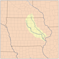
Cedar River (Iowa)
Encyclopedia
River
A river is a natural watercourse, usually freshwater, flowing towards an ocean, a lake, a sea, or another river. In a few cases, a river simply flows into the ground or dries up completely before reaching another body of water. Small rivers may also be called by several other names, including...
in Minnesota
Minnesota
Minnesota is a U.S. state located in the Midwestern United States. The twelfth largest state of the U.S., it is the twenty-first most populous, with 5.3 million residents. Minnesota was carved out of the eastern half of the Minnesota Territory and admitted to the Union as the thirty-second state...
and Iowa
Iowa
Iowa is a state located in the Midwestern United States, an area often referred to as the "American Heartland". It derives its name from the Ioway people, one of the many American Indian tribes that occupied the state at the time of European exploration. Iowa was a part of the French colony of New...
. It is a tributary of the Iowa River
Iowa River
The Iowa River is a tributary of the Mississippi River in the state of Iowa in the United States. It is about long and is open to small river craft to Iowa City, about from its mouth...
, which flows to the Mississippi River
Mississippi River
The Mississippi River is the largest river system in North America. Flowing entirely in the United States, this river rises in western Minnesota and meanders slowly southwards for to the Mississippi River Delta at the Gulf of Mexico. With its many tributaries, the Mississippi's watershed drains...
. The Cedar River takes its name from the red cedar
Juniperus virginiana
Juniperus virginiana is a species of juniper native to eastern North America, from southeastern Canada to the Gulf of Mexico, east of the Great Plains...
(Juniperus virginiana) trees growing there. The surrounding region is known officially as the Cedar River Valley, though it is more commonly referred to simply as the Cedar Valley.
Geography
The headwatersSource (river or stream)
The source or headwaters of a river or stream is the place from which the water in the river or stream originates.-Definition:There is no universally agreed upon definition for determining a stream's source...
of the Cedar River are located in Dodge County, Minnesota
Dodge County, Minnesota
As of the census of 2000, there were 17,731 people, 6,420 households, and 4,853 families residing in the county. The population density was 40 people per square mile . There were 6,642 housing units at an average density of 15 per square mile...
, consisting of a west fork and middle fork approximately three miles northeast of the town of Blooming Prairie
Blooming Prairie, Minnesota
Blooming Prairie is a city in Dodge and Steele counties in the U.S. state of Minnesota. The population was 1,996 at the 2010 census. Most of the city lies in Steele County; only a small part of the city extends into Dodge County.-History:...
, and an east fork approximately one mile south of the town of Hayfield
Hayfield, Minnesota
Hayfield is a city in Dodge County, Minnesota, United States. The population was 1,340 at the 2010 census.-Geography:According to the United States Census Bureau, the city has a total area of , all of it land.-Transportation:...
. It then flows into Mower County, Minnesota
Mower County, Minnesota
As of the census of 2000, there were 38,603 people, 15,582 households, and 10,315 families residing in the county. The population density was 54 people per square mile . There were 16,251 housing units at an average density of 23 per square mile...
through the townships
Township (United States)
A township in the United States is a small geographic area. Townships range in size from 6 to 54 square miles , with being the norm.The term is used in three ways....
of Udolpho, Lansing, Austin (where Turtle Creek and Dobbins Creek join it), and Lyle. It then flows into Mitchell County, Iowa
Mitchell County, Iowa
-2010 census:The 2010 census recorded a population of 10,776 in the county, with a population density of . There were 4,850 housing units, of which 4,395 were occupied.-2000 census:According to the U.S...
and Floyd County, Iowa
Floyd County, Iowa
-2010 census:The 2010 census recorded a population of 16,303 in the county, with a population density of . There were 7,526 housing units, of which 6,886 were occupied.-2000 census:...
with the endpoint being located in Louisa County, Iowa
Louisa County, Iowa
-2010 census:The 2010 census recorded a population of 11,387 in the county, with a population density of . There were 5,002 housing units, of which 4,346 were occupied.-2000 census:...
at the town of Columbus Junction
Columbus Junction, Iowa
Columbus Junction is a city in Louisa County, Iowa, United States. The population was 1,900 at the 2000 census. It is part of the Muscatine Micropolitan Statistical Area....
, where it joins with the Iowa River
Iowa River
The Iowa River is a tributary of the Mississippi River in the state of Iowa in the United States. It is about long and is open to small river craft to Iowa City, about from its mouth...
which then winds its way to the Mississippi River
Mississippi River
The Mississippi River is the largest river system in North America. Flowing entirely in the United States, this river rises in western Minnesota and meanders slowly southwards for to the Mississippi River Delta at the Gulf of Mexico. With its many tributaries, the Mississippi's watershed drains...
. Despite being a tributary of the Iowa River, it appears larger than the Iowa River at their confluence point. Palisades-Kepler State Park is located on the Cedar River near Cedar Rapids.
Cedar County, Iowa
-2010 census:The 2010 census recorded a population of 13,956 in the county, with a population density of . There were 8,064 housing units, of which 7,511 were occupied.-2000 census:...
is named for the river.
Major cities (with populations greater than 20,000) located along the Cedar River include Austin, Minnesota
Austin, Minnesota
As of the census of 2000, there were 23,314 people, 9,897 households, and 6,076 families residing in the city. The population density was 2,168.2 people per square mile . There were 10,261 housing units at an average density of 954.3 per square mile...
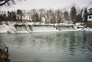
, Cedar Falls, Iowa
Cedar Falls, Iowa
Cedar Falls is a city in Black Hawk County, Iowa, United States, and it is home to one of Iowa's three public universities, the University of Northern Iowa. The population was 39,260 in the 2010 census, an increase from the 36,145 population in the 2000 census...
, Waterloo, Iowa
Waterloo, Iowa
Waterloo is a city in and the county seat of Black Hawk County, Iowa, United States. As of the 2010 United States Census the population decreased by 0.5% to 68,406. Waterloo is part of the Waterloo – Cedar Falls Metropolitan Statistical Area, and is the more populous of the two...
, and Cedar Rapids, Iowa
Cedar Rapids, Iowa
Cedar Rapids is the second largest city in Iowa and is the county seat of Linn County. The city lies on both banks of the Cedar River, north of Iowa City and east of Des Moines, the state's capital and largest city...
.