

Ceann Ear
Encyclopedia
Disambiguation: "Ceann Ear" is a common Scottish placename meaning Eastern Headland
Ceann Ear is the largest island in the Monach
or Heisgeir group off North Uist
in north west Scotland. It is 231 hectare (0.891895986348756 sq mi) in size and connected by sandbanks to Ceann Iar
via Sibhinis
at low tide. It is said that it was at one time possible to walk all the way to Baleshare
, and on to North Uist
, 5 miles (8 km) away at low tide. In the 16th century, a large tidal wave was said to have washed this away.
Today the islands are a National Nature Reserve
.
 Ceann Ear had been settled for at least a thousand years, before being finally abandoned. Like the other Monach Islands, it was originally abandoned due to overgrazing
, and resettled in the wake of the Highland Clearances
.
In the 13th century, a chapel was established, which had links to Iona
. This monastery was probably at Cladh na Beide in the north east. The monks were responsible for maintaining a light on nearby Shillay
to warn ships. Ceann Ear was also known as "Heisgeir nan Cailleach" ("Heisker of the Nuns") due to a nunnery which may have been established in the 13th century. (Cailleach is usually translated as "old woman", but originally meant a nun.)
Unusually, the islanders had their grain drying kilns inside their houses. This is not common at all in the Hebrides, but more a feature of Shetland.
There are still the remains of the village in the south of the island, and the old schoolhouse is upkept as a fisherman's shelter. There was formerly a post office and a school here, but no shops.
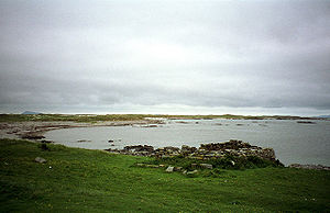
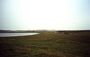 A low lying, sandy island, subject to intense coastal erosion. The highest point is Coilleag Mhòr nan Dàmh at Gortinish at the north east of the island.
Gale force winds blast the Monach Isles on about 160 days of the year. Only certain plants, such as marram grass, can withstand the constant blown sand and salt spray. Farther inland, there are more permanent patches of damp grassland, the wettest having rushes and moss. There are only a few tiny lochs, all rather salty and some only seasonal. The remains of the little village of Ceann Ear are clustered around the largest one (Loch nam Buadh), but the villagers used to get their freshwater from a few wells nearby.
Ceann Ear is the largest island in the Monach
Monach Islands
Not to be confused with Heysker/Hyskeir or HaskeirThe Monach Islands, also known as Heisker , are an island group west of North Uist in the Outer Hebrides of Scotland...
or Heisgeir group off North Uist
North Uist
North Uist is an island and community in the Outer Hebrides of Scotland.-Geography:North Uist is the tenth largest Scottish island and the thirteenth largest island surrounding Great Britain. It has an area of , slightly smaller than South Uist. North Uist is connected by causeways to Benbecula...
in north west Scotland. It is 231 hectare (0.891895986348756 sq mi) in size and connected by sandbanks to Ceann Iar
Ceann Iar
Disambiguation: "Ceann Iar" is a common Scottish placename meaning Western HeadlandCeann Iar is one of the Monach Isles/Heisgeir, to the west of North Uist in the Outer Hebrides. It is a slender island, approximately a mile, or two kilometres long.-Geography:Ceann Iar is the second largest of the...
via Sibhinis
Sibhinis
Sibhinis, Siobhanais or Shivinish. is one of the Monach Islands, lying between Ceann Iar and Ceann Ear. It is tidal, and connected at low tide to Ceann Iar by Fadhail Shibhinis, and to Ceann Ear by Faodhail Chinn Ear. It is 16m at its highest point...
at low tide. It is said that it was at one time possible to walk all the way to Baleshare
Baleshare
Baleshare is a flat tidal island in the Outer Hebrides of Scotland.Baleshare lies to the south-west of North Uist. Its economics and community were boosted by the building of a causeway in 1962. The 350m causeway was built by William Tawse Ltd. The island is extremely flat by Hebridean standards,...
, and on to North Uist
North Uist
North Uist is an island and community in the Outer Hebrides of Scotland.-Geography:North Uist is the tenth largest Scottish island and the thirteenth largest island surrounding Great Britain. It has an area of , slightly smaller than South Uist. North Uist is connected by causeways to Benbecula...
, 5 miles (8 km) away at low tide. In the 16th century, a large tidal wave was said to have washed this away.
Today the islands are a National Nature Reserve
National Nature Reserve
For details of National nature reserves in the United Kingdom see:*National Nature Reserves in England*National Nature Reserves in Northern Ireland*National Nature Reserves in Scotland*National Nature Reserves in Wales...
.
Human Settlement
Overgrazing
Overgrazing occurs when plants are exposed to intensive grazing for extended periods of time, or without sufficient recovery periods. It can be caused by either livestock in poorly managed agricultural applications, or by overpopulations of native or non-native wild animals.Overgrazing reduces the...
, and resettled in the wake of the Highland Clearances
Highland Clearances
The Highland Clearances were forced displacements of the population of the Scottish Highlands during the 18th and 19th centuries. They led to mass emigration to the sea coast, the Scottish Lowlands, and the North American colonies...
.
In the 13th century, a chapel was established, which had links to Iona
Iona
Iona is a small island in the Inner Hebrides off the western coast of Scotland. It was a centre of Irish monasticism for four centuries and is today renowned for its tranquility and natural beauty. It is a popular tourist destination and a place for retreats...
. This monastery was probably at Cladh na Beide in the north east. The monks were responsible for maintaining a light on nearby Shillay
Shillay
Shillay is an uninhabited island which lies 2 km north of Pabbay in the Outer Hebrides of Scotland.The name is derived from the Norse selr-øy meaning seal island and is a Scottish Wildlife Trust reserve owing to its international importance for breeding grey seals.The is no record or evidence...
to warn ships. Ceann Ear was also known as "Heisgeir nan Cailleach" ("Heisker of the Nuns") due to a nunnery which may have been established in the 13th century. (Cailleach is usually translated as "old woman", but originally meant a nun.)
Unusually, the islanders had their grain drying kilns inside their houses. This is not common at all in the Hebrides, but more a feature of Shetland.
There are still the remains of the village in the south of the island, and the old schoolhouse is upkept as a fisherman's shelter. There was formerly a post office and a school here, but no shops.
Geography
Gale force winds blast the Monach Isles on about 160 days of the year. Only certain plants, such as marram grass, can withstand the constant blown sand and salt spray. Farther inland, there are more permanent patches of damp grassland, the wettest having rushes and moss. There are only a few tiny lochs, all rather salty and some only seasonal. The remains of the little village of Ceann Ear are clustered around the largest one (Loch nam Buadh), but the villagers used to get their freshwater from a few wells nearby.