
Cayo Santiago
Encyclopedia
Island
An island or isle is any piece of sub-continental land that is surrounded by water. Very small islands such as emergent land features on atolls can be called islets, cays or keys. An island in a river or lake may be called an eyot , or holm...
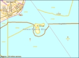
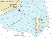
, located at 18°09′23"N 65°44′03"W, 950 m (0.6 mi) southeast of Punta Santiago, Humacao
Humacao, Puerto Rico
Humacao is a city in Puerto Rico located in the eastern coast of the island, north of Yabucoa; south of Naguabo; east of Las Piedras; and west of Vieques Passage. Humacao is spread over 10 wards and Humacao Pueblo...
, Puerto Rico
Puerto Rico
Puerto Rico , officially the Commonwealth of Puerto Rico , is an unincorporated territory of the United States, located in the northeastern Caribbean, east of the Dominican Republic and west of both the United States Virgin Islands and the British Virgin Islands.Puerto Rico comprises an...
.
Geography
It extends 600 m (656 yd) north-south and 400 m (437 yd) east-west, including the flat northeastern peninsulaPeninsula
A peninsula is a piece of land that is bordered by water on three sides but connected to mainland. In many Germanic and Celtic languages and also in Baltic, Slavic and Hungarian, peninsulas are called "half-islands"....
which is connected to the main part only by a narrow sandy isthmus
Isthmus
An isthmus is a narrow strip of land connecting two larger land areas usually with waterforms on either side.Canals are often built through isthmuses where they may be particularly advantageous to create a shortcut for marine transportation...
. 600 meters west of the southermost point is a shoal, Bajo Evelyn, which has a least depth of 8 fathom
Fathom
A fathom is a unit of length in the imperial and the U.S. customary systems, used especially for measuring the depth of water.There are 2 yards in an imperial or U.S. fathom...
s. While the island is flat in the north, it reaches a height of 34.9 m (104.5 ft) 2.9 km (1.8 mi) southwest of the port, in a small rocky hill called El Morrillo, which rises abruptly from the water and the lowland around it. The area of the island is 0.14 km² (139,179 m²: Block
Census block
A census block is the smallest geographic unit used by the United States Census Bureau for tabulation of 100-percent data . Several blocks make up block groups, which again make up census tracts. There are on average about 39 blocks per block group, but there are variations...
2000, Census Block Group
Census block group
A census block group is a geographical unit used by the United States Census Bureau which is between the census tract and the census block. It is the smallest geographical unit for which the bureau publishes sample data, i.e data which is only collected from a fraction of all households.Census...
2, Census tract
Census tract
A census tract, census area, or census district is a geographic region defined for the purpose of taking a census. Usually these coincide with the limits of cities, towns or other administrative areas and several tracts commonly exist within a county...
1801, Humacao Municipio, Puerto Rico), of which the northwestern peninsula accounts for about 0.02 km². The island is part of Punta Santiago barrio
Barrio
Barrio is a Spanish word meaning district or neighborhood.-Usage:In its formal usage in English, barrios are generally considered cohesive places, sharing, for example, a church and traditions such as feast days...
of Humacao.
Fauna

India
India , officially the Republic of India , is a country in South Asia. It is the seventh-largest country by geographical area, the second-most populous country with over 1.2 billion people, and the most populous democracy in the world...
that were used for scientific research in 1938. Today, the island serves as a research center for the University of Puerto Rico
University of Puerto Rico
The University of Puerto Rico is the state university system of Puerto Rico. The system consists of 11 campuses and has approximately 64,511 students and 5,300 faculty members...
(Caribbean Primate Research Center), the National Institutes of Health
National Institutes of Health
The National Institutes of Health are an agency of the United States Department of Health and Human Services and are the primary agency of the United States government responsible for biomedical and health-related research. Its science and engineering counterpart is the National Science Foundation...
, Yale University
Yale University
Yale University is a private, Ivy League university located in New Haven, Connecticut, United States. Founded in 1701 in the Colony of Connecticut, the university is the third-oldest institution of higher education in the United States...
, and Harvard University
Harvard University
Harvard University is a private Ivy League university located in Cambridge, Massachusetts, United States, established in 1636 by the Massachusetts legislature. Harvard is the oldest institution of higher learning in the United States and the first corporation chartered in the country...
. The station accommodates 11 researchers and technicians who take the short boat trip from Humacao on a daily basis and normally don't stay on the island.
Cayo Batata
Cayo Batata
Cayo Batata is an uninhabited, grass-covered island, located at , 600 m east of Morro de Humacao, the closest mainland feature , in Humacao, Puerto Rico.-Geography:...
, the second island belonging to Humacao, is located 5.7 km to the southwest.