
Cavanal Hill
Encyclopedia
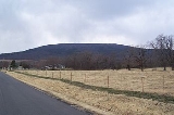
Cavanal Hill located near Poteau, Oklahoma
, is billed by a local chamber of commerce as the tallest hill
in the world at 1999 feet (609.3 m). The actual summit elevation is 2385 feet (726.9 m) above sea level; the difference in elevation between the summit and the Poteau River
3 miles (5 km) to the north is 1960 feet (597.4 m).
The billing is based on the delineation between a hill and a mountain
, that being if the geographical feature were 2,000 feet or higher than its base, then it would be classified as a mountain instead of a hill.
. Cavanal Hill has a main road that leads to the top. There, you can see a large view of Sugar Loaf Mountain, Poteau, and the Ouachita Mountains
.
Poteau, Oklahoma
Poteau is a city in Le Flore County, Oklahoma, United States. It is part of the Fort Smith, Arkansas-Oklahoma Metropolitan Statistical Area. The population was 8,520 at the 2010 census, ranking fifth in the Greater Fort Smith Area. It is the county seat of Le Flore County...
, is billed by a local chamber of commerce as the tallest hill
Hill
A hill is a landform that extends above the surrounding terrain. Hills often have a distinct summit, although in areas with scarp/dip topography a hill may refer to a particular section of flat terrain without a massive summit A hill is a landform that extends above the surrounding terrain. Hills...
in the world at 1999 feet (609.3 m). The actual summit elevation is 2385 feet (726.9 m) above sea level; the difference in elevation between the summit and the Poteau River
Poteau River
The Poteau River is a river in the U.S. states of Arkansas and Oklahoma and is the only river in Oklahoma that flows north. Poteau is the French word for "post" and it is believed the river was named because French explorers used a post or stake to mark the mouth of the river. The city of Poteau,...
3 miles (5 km) to the north is 1960 feet (597.4 m).
The billing is based on the delineation between a hill and a mountain
Mountain
Image:Himalaya_annotated.jpg|thumb|right|The Himalayan mountain range with Mount Everestrect 58 14 160 49 Chomo Lonzorect 200 28 335 52 Makalurect 378 24 566 45 Mount Everestrect 188 581 920 656 Tibetan Plateaurect 250 406 340 427 Rong River...
, that being if the geographical feature were 2,000 feet or higher than its base, then it would be classified as a mountain instead of a hill.
History
The area of Cavanal Hill was once an old mining town called Witteville. This was absorbed by Poteau since the Great DepressionGreat Depression
The Great Depression was a severe worldwide economic depression in the decade preceding World War II. The timing of the Great Depression varied across nations, but in most countries it started in about 1929 and lasted until the late 1930s or early 1940s...
. Cavanal Hill has a main road that leads to the top. There, you can see a large view of Sugar Loaf Mountain, Poteau, and the Ouachita Mountains
Ouachita Mountains
The Ouachita Mountains are a mountain range in west central Arkansas and southeastern Oklahoma. The range's subterranean roots may extend as far as central Texas, or beyond it to the current location of the Marathon Uplift. Along with the Ozark Mountains, the Ouachita Mountains form the U.S...
.