
Cape Perpetua
Encyclopedia
Headlands and bays
Headlands and bays are two related features of the coastal environment.- Geology and geography :Headlands and bays are often found on the same coastline. A bay is surrounded by land on three sides, whereas a headland is surrounded by water on three sides. Headlands are characterized by high,...
on the central Oregon Coast
Oregon Coast
The Oregon Coast is a region of the U.S. state of Oregon. It runs generally north-south along the Pacific Ocean, forming the western border of the state; the region is bounded to the east by the Oregon Coast Range. The Oregon Coast stretches approximately from the Columbia River in the north to...
which projects into the Pacific Ocean
Pacific Ocean
The Pacific Ocean is the largest of the Earth's oceanic divisions. It extends from the Arctic in the north to the Southern Ocean in the south, bounded by Asia and Australia in the west, and the Americas in the east.At 165.2 million square kilometres in area, this largest division of the World...
. The land is managed by the United States Forest Service
United States Forest Service
The United States Forest Service is an agency of the United States Department of Agriculture that administers the nation's 155 national forests and 20 national grasslands, which encompass...
as part of the Siuslaw National Forest
Siuslaw National Forest
Siuslaw National Forest is a national forest in western Oregon, United States. Established in 1908, the Siuslaw is made up of a wide variety of ecosystems, ranging from coastal forests to sand dunes.- Geography :...
.
Geography
Cape Perpetua is located about 2 miles (3 km) south of Yachats, OregonYachats, Oregon
Yachats is a small coastal city in Lincoln County, Oregon, United States. According to Oregon Geographic Names, the name comes from the Siletz language, and means "dark water at the foot of the mountain". There is a range of differing etymologies, however. William Bright says the name comes from...
along U.S. Route 101. It is a typical Pacific Northwest
Pacific Northwest
The Pacific Northwest is a region in northwestern North America, bounded by the Pacific Ocean to the west and, loosely, by the Rocky Mountains on the east. Definitions of the region vary and there is no commonly agreed upon boundary, even among Pacific Northwesterners. A common concept of the...
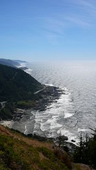
headland, forming a high steep bluff above the ocean. At its highest point, Cape Perpetua rises to over 800 feet (243.8 m) above sea level. From its crest, an observer can see 70 miles (112.7 km) of Oregon coastline and as far as 37 miles (59.5 km) out to sea on a clear day.
History
For at least 6,000 years Native AmericansIndigenous peoples of the Americas
The indigenous peoples of the Americas are the pre-Columbian inhabitants of North and South America, their descendants and other ethnic groups who are identified with those peoples. Indigenous peoples are known in Canada as Aboriginal peoples, and in the United States as Native Americans...
hunted for mussels, crabs, sea urchins, and clams along the coast near Cape Perpetua. Evidence of their lives can still be found in the huge piles of discarded mussel shells that lie along the shore near the Cape Perpetua Visitor Center.
Several early explorers sailed past the cape. The first recorded passage was by Bartolomé Ferrelo
Bartolomé Ferrelo
Bartolomé Ferrelo, also known as Bartolomé Ferrer, born 1499 in Bilbao Spain, died 1550 in Mexico.He was the pilot for Juan Rodrigo Cabrillo, the Portuguese captain who was sent by the viceroy of Mexico, with two ships in 1542 to explore what is now Northern California...
in 1543; then came Sir Frances Drake in 1575 and Martin d'Aguilar
Martin d'Aguilar
Martin d'Aguilar was a Spanish explorer whose log contains one of the first written descriptions of the coast of the U.S. state of Oregon.Aguilar was the commander of the ship Tres Reyes in an expedition led by Sebastián Vizcaíno. Vizcaíno set out from Mexico in 1602 in search of usable harbors and...
in 1605. The cape was named by Captain James Cook on March 7, 1778 as he searched for the Pacific entrance to a Northwest Passage
Northwest Passage
The Northwest Passage is a sea route through the Arctic Ocean, along the northern coast of North America via waterways amidst the Canadian Arctic Archipelago, connecting the Atlantic and Pacific Oceans...
. Cook named the cape Perpetua because it was sighted on St. Perpetua's Day.
The area became part of the Siuslaw National Forest
Siuslaw National Forest
Siuslaw National Forest is a national forest in western Oregon, United States. Established in 1908, the Siuslaw is made up of a wide variety of ecosystems, ranging from coastal forests to sand dunes.- Geography :...
in 1908. In 1914, the United States Forest Service
United States Forest Service
The United States Forest Service is an agency of the United States Department of Agriculture that administers the nation's 155 national forests and 20 national grasslands, which encompass...
cut a narrow road into the cliff around Cape Perpetua and constructed a wooden bridge across the Yachats River
Yachats River
The Yachats River is a short river on the central Oregon coast, about west-north-west of Eugene. The name is the native name meaning at the foot of the mountain....
, opening travel between the small community of Yachats
Yachats, Oregon
Yachats is a small coastal city in Lincoln County, Oregon, United States. According to Oregon Geographic Names, the name comes from the Siletz language, and means "dark water at the foot of the mountain". There is a range of differing etymologies, however. William Bright says the name comes from...
and Florence, Oregon
Florence, Oregon
Florence is a city in Lane County, Oregon, United States. As of the 2010 census, the city had a total population of 8,466.-History:The Florence area was originally inhabited by the Siuslaw tribe of Native Americans. Some state that the city was named for state senator A. B...
to the south. The wooden bridge was replaced in 1926 with a steel structure. The Cape Perpetua section of the Roosevelt Memorial Highway (now Highway 101
U.S. Route 101 in Oregon
In the U.S. state of Oregon, U.S. Route 101, a major north–south U.S. Highway, runs through the state along the coastline near the Pacific Ocean. In Oregon, it runs from the Oregon–California border, south of Brookings, to the Oregon–Washington border on the Columbia River, between Astoria,...
) was built in the 1930s.
In 1933, a Civilian Conservation Corps
Civilian Conservation Corps
The Civilian Conservation Corps was a public work relief program that operated from 1933 to 1942 in the United States for unemployed, unmarried men from relief families, ages 18–25. A part of the New Deal of President Franklin D...
(CCC) camp was built at the foot of the cape just north of Cape Creek near where the Cape Perpetua Visitor Center is located today. The CCC constructed Cape Perpetua campground, a network of trails, and the West Shelter observation point near the top of cape. During World War II
World War II
World War II, or the Second World War , was a global conflict lasting from 1939 to 1945, involving most of the world's nations—including all of the great powers—eventually forming two opposing military alliances: the Allies and the Axis...
, the West Shelter observation point was used as a coastal watch station and a large coastal defense gun was temporarily installed. An SCR-270B radar was installed at an undetermined location to take advantage of the height of the promontory.
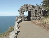
The Cape Perpetua Shelter and Parapet were listed on the National Register of Historic Places
National Register of Historic Places
The National Register of Historic Places is the United States government's official list of districts, sites, buildings, structures, and objects deemed worthy of preservation...
in 1989.
Cape Perpetua Scenic Area
The Forest Service created the Cape Perpetua Scenic Area and built the Cape Perpetua Visitor Center in the 1960s to highlight the unique beauty of the central Oregon coastOregon Coast
The Oregon Coast is a region of the U.S. state of Oregon. It runs generally north-south along the Pacific Ocean, forming the western border of the state; the region is bounded to the east by the Oregon Coast Range. The Oregon Coast stretches approximately from the Columbia River in the north to...
. The scenic area includes 2700 acres (10.9 km²) of old growth spruce, Douglas-fir
Douglas-fir
Douglas-fir is one of the English common names for evergreen coniferous trees of the genus Pseudotsuga in the family Pinaceae. Other common names include Douglas tree, and Oregon pine. There are five species, two in western North America, one in Mexico, and two in eastern Asia...
and western hemlock
Western Hemlock
Tsuga heterophylla. the Western Hemlock, is a species of hemlock native to the west coast of North America, with its northwestern limit on the Kenai Peninsula, Alaska, and its southeastern limit in northern Sonoma County, California.-Habitat:...
.
Camping, picnicking, hiking, sightseeing, whale watching, and a visitor center with daily programs are all available within the Cape Perpetua Scenic Area. There are twenty-six miles of interconnected hiking trails in old growth forests which lead to Pacific Ocean tidal pools. One of the trails leads to a 600 year old Giant Sitka Spruce
Sitka Spruce
Picea sitchensis, the Sitka Spruce, is a large coniferous evergreen tree growing to 50–70 m tall, exceptionally to 95 m tall, and with a trunk diameter of up to 5 m, exceptionally to 6–7 m diameter...
known as the Silent Sentinel of the Siuslaw. This tree stands more than 185 feet (56.4 m) high, and has a 40 feet (12.2 m) circumference at its base. On 15 September 2007, this ancient spruce was designated a "Heritage Tree" by the State of Oregon to recognize its exceptional age and size and ensure its protection.
Devils Churn
Devils Churn is a narrow inlet of the Pacific Ocean in Lincoln County, Oregon, United States, south of Yachats. It is located in the Siuslaw National Forest and is accessible via the Restless Waters trail from the Cape Perpetua Scenic Area visitor's center or the U.S. Route 101 overlook...
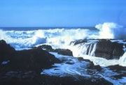
is a long crack in the coastal rock that fills with each ocean wave, occasionally exploding as incoming and outgoing waves collide. The Spouting Horn (also known as Thor's Well) is a salt water fountain driven by the power of the ocean tide. The Devil’s Churn and the Spouting Horn are popular with visitors; however, both can be dangerous especially at high tide and during winter storms.
The Cape Perpetua Visitor Center is located two miles (3 km) south of Yachats. The visitor center offers spectacular views of the ocean and coast from its deck. It is also a popular place to watch migrating gray whale
Gray Whale
The gray whale, Eschrichtius robustus, is a baleen whale that migrates between feeding and breeding grounds yearly. It reaches a length of about , a weight of , and lives 50–70 years. The common name of the whale comes from the gray patches and white mottling on its dark skin. Gray whales were...
s. The visitor center has comprehensive natural history and cultural exhibits, an interactive children's science area, a theater with nature films, and a bookstore. At the shelter there was never a gun installation. An SCR270B radar was installed on the site in 1943 in response to the bombing of Mt. Emily Brookings Oregon.