

Cape Buller
Encyclopedia
Headland
A headland is a point of land, usually high and often with a sheer drop, that extends out into a body of water.Headland can also refer to:*Headlands and bays*headLand, an Australian television series...
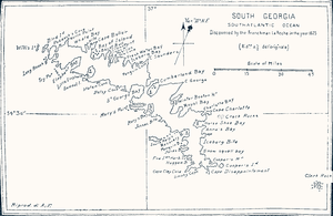
forming the west side of the entrance to the Bay of Isles
Bay of Isles
The Bay of Isles is a bay wide and receding , lying between Cape Buller and Cape Wilson along the north coast of South Georgia. It was discovered in 1775 by a British expedition under James Cook and so named by him because numerous islands lie in the bay, many of which are named after local birds...
on the north coast of South Georgia. It was discovered and named in 1775 by a British expedition under James Cook
James Cook
Captain James Cook, FRS, RN was a British explorer, navigator and cartographer who ultimately rose to the rank of captain in the Royal Navy...
.
The area including the Bay of Isles and Cape Wilson, along with Grytviken
Grytviken
Grytviken is the principal settlement in the British territory of South Georgia in the South Atlantic. It was so named in 1902 by the Swedish surveyor Johan Gunnar Andersson who found old English try pots used to render seal oil at the site. It is the best harbour on the island, consisting of a...
is one of two Areas of Special Tourist Interest on the island.