

Caminito del Rey
Encyclopedia
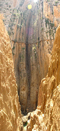
El Chorro
El Chorro is a limestone gorge in Andalusia in southern Spain, through which passes the Guadalhorce river. It was dammed in 1921, forming three reservoirs which are flanked by pine forests....
, near Álora
Álora
Álora is a town of southern Spain, part of the province of Málaga, located c. 40 km from Málaga, on the right bank of the river Guadalhorce, and on the Córdoba-Málaga high-speed rail line...
in the province of Málaga
Málaga (province)
The Province of Málaga is located on the southern coast of Spain, in the Autonomous Community of Andalusia. It is bordered by the Mediterranean Sea to the South, and by the provinces of Cádiz, Sevilla, Córdoba and Granada.Its area is 7,308 km²...
, Spain
Spain
Spain , officially the Kingdom of Spain languages]] under the European Charter for Regional or Minority Languages. In each of these, Spain's official name is as follows:;;;;;;), is a country and member state of the European Union located in southwestern Europe on the Iberian Peninsula...
. The name is often shortened to Camino del Rey (King's pathway).
History
In 1901 it became apparent that workers at the hydroelectric power plants at Chorro Falls and Gaitanejo Falls needed a walkway to cross between the falls, to provide for transport of materials, and for the inspection and maintenance of the channel. Construction of the walkway took four years and it was finished in 1905.In 1921 King Alfonso XIII
Alfonso XIII of Spain
Alfonso XIII was King of Spain from 1886 until 1931. His mother, Maria Christina of Austria, was appointed regent during his minority...
crossed the walkway for the inauguration of the dam Conde del Guadalhorce and it became known by its present name.
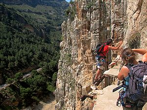
In June 2011, the regional government of Andalusia and the local government of Málaga agreed to share costs of restoration (including car parking and a museum) of €9 million. The project will take approximately three years to complete. Many of the original features will remain in place and the new materials that are used will be in keeping with the old design.
External links
- Guide to Hiking El Camino Del Rey Safely + Photos,
- 3D Virtual Tour, 20/03/2011
- Full length video taken by a hiker, a test for acrophobiaAcrophobiaAcrophobia is an extreme or irrational fear of heights. It belongs to a category of specific phobias, called space and motion discomfort that share both similar etiology and options for treatment.Most people experience a degree of natural fear when exposed to heights, especially if there is little...
- Traversing the legendary Camino del Rey
- Trip report, Description & Photos of the Walkway
- World's most dangerous hiking trail video
- Walking the Camino del Rey, 2011. High definition video