
California State Route 32
Encyclopedia
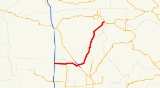
State Route 32 is an east–west state highway
in the U.S. State
of California
which is routed from Interstate 5 in Orland
, through Chico
, through the northern Sierra Nevada, ending at SR 36
and SR 89
in eastern Tehama County
.
.
SR 32 begins in Orland
at a junction with I-5 as Newville Road. The highway continues east out of Orland for several miles before entering Hamilton City
and intersecting SR 45. SR 32 then crosses the Sacramento River
into Butte County
. East of here, SR 32 enters the city of Chico
, becoming Walnut Street before it becomes a one-way couplet as 8th and 9th Streets through downtown Chico. Shortly after the diamond interchange
with the SR 99 freeway, 8th and 9th Streets merge into one road and SR 32 continues east out of the Chico city limits.
Following this, SR 32 turns to the northeast, passing through the communities of Forest Ranch
and West Branch
before crossing into Tehama County
and eventually Lassen National Forest
. SR 32 terminates at an intersection with SR 89 and SR 36.
Different road names include Nord Avenue (Chico), Walnut Street (Chico), West Eighth and Ninth Streets (Chico), East Eighth and Ninth Streets (Chico), Deer Creek Highway (Chico), East and West Sixth Street (Hamilton City), Walker Street (Orland), Newville Road (Orland) and County Road 200.
{| class=wikitable
!County
!Location
!Postmile
!Destinations
!Notes
|-
|rowspan=4|Glenn
GLE L0.00-10.91
|rowspan=3|Orland
|L0.00
|Newville Road – Newville
|Continuation beyond I-5
|-
|L0.00
|
|Interchange
|-
|0.00
|
|Former US 99W
|-
|Hamilton City
|9.63
|
|
|-
|rowspan=6|Butte
BUT 0.00-37.75
|
|
|Hamilton Nord Cana Highway – Nord
|
|-
|
|6.24
| North Lindo Avenue, East Avenue to SR 99
|
|-
|rowspan=4|Chico
|9.08
| – Downtown Chico
|
|-
|10.19
|
|Interchange
|-
|11.01
|Forest Avenue
|
|-
|11.70
|Bruce Road
|
|-
|Tehama
TEH 0.00-2.71
|colspan=4 align=center|No junctions
|-
|Butte
BUT 2.71-4.70
|colspan=4 align=center|No junctions
|-
|Tehama
TEH 4.70-R24.88
|
|R24.88
|
|
State highway
State highway, state road or state route can refer to one of three related concepts, two of them related to a state or provincial government in a country that is divided into states or provinces :#A...
in the U.S. State
U.S. state
A U.S. state is any one of the 50 federated states of the United States of America that share sovereignty with the federal government. Because of this shared sovereignty, an American is a citizen both of the federal entity and of his or her state of domicile. Four states use the official title of...
of California
California
California is a state located on the West Coast of the United States. It is by far the most populous U.S. state, and the third-largest by land area...
which is routed from Interstate 5 in Orland
Orland, California
Orland is a city in Glenn County, California. The population was 7,291 at the 2010 census, up from 6,281 at the 2000 census, making Orland the most populous city in Glenn County. Orland is located north of Willows, at an elevation of 259 feet . Interstate 5, passes west of the downtown area while...
, through Chico
Chico, California
Chico is the most populous city in Butte County, California, United States. The population was 86,187 at the 2010 census, up from 59,954 at the time of the 2000 census...
, through the northern Sierra Nevada, ending at SR 36
California State Route 36
State Route 36 is an east–west state highway in the U.S. state of California that is routed from U.S. Route 101 in Humboldt County to U.S. Route 395 just east of Susanville in Lassen County. The portion of SR 36 travelling past Lassen Volcanic National Park and Lake Almanor is part of the...
and SR 89
California State Route 89
State Route 89 is a California State Highway that travels in the north–south direction, and is the major thoroughfare for many mountain communities. It starts from U.S. Route 395 near Topaz Lake, winding its way up to the Monitor Pass, down to the Carson River, and up again over the Luther...
in eastern Tehama County
Tehama County, California
Tehama County is a county located in the northern part of the U.S. state of California. It is bisected by the Sacramento River. As of 2010 its population was 63,463, up from 56,039 as of 2000. The county seat is Red Bluff.-History:...
.
Route description
This route is part of the California Freeway and Expressway SystemCalifornia Freeway and Expressway System
The California Freeway and Expressway System is a system of existing or planned freeways and expressways in the U.S. state of California. It is defined by the Streets and Highways Code.-List of roads in the system:*State Route 1 *State Route 2...
.
SR 32 begins in Orland
Orland, California
Orland is a city in Glenn County, California. The population was 7,291 at the 2010 census, up from 6,281 at the 2000 census, making Orland the most populous city in Glenn County. Orland is located north of Willows, at an elevation of 259 feet . Interstate 5, passes west of the downtown area while...
at a junction with I-5 as Newville Road. The highway continues east out of Orland for several miles before entering Hamilton City
Hamilton City, California
Hamilton City is a census-designated place in Glenn County, California, United States. The population was 1,759 at the 2010 census, down from 1,903 at the 2000 census. Hamilton City is located east of Orland, and 10 miles west of Chico at an elevation of 151 feet . The default numbers used for...
and intersecting SR 45. SR 32 then crosses the Sacramento River
Sacramento River
The Sacramento River is an important watercourse of Northern and Central California in the United States. The largest river in California, it rises on the eastern slopes of the Klamath Mountains, and after a journey south of over , empties into Suisun Bay, an arm of the San Francisco Bay, and...
into Butte County
Butte County, California
Butte County is a county located in the Central Valley of the US state of California, north of the state capital of Sacramento. As of the 2010 census, it had a population of 220,000. The county seat is Oroville. Butte County is the "Land of Natural Wealth and Beauty."Butte County is watered by the...
. East of here, SR 32 enters the city of Chico
Chico, California
Chico is the most populous city in Butte County, California, United States. The population was 86,187 at the 2010 census, up from 59,954 at the time of the 2000 census...
, becoming Walnut Street before it becomes a one-way couplet as 8th and 9th Streets through downtown Chico. Shortly after the diamond interchange
Diamond interchange
A diamond interchange is a common type of road junction, used where a freeway crosses a minor road. The freeway itself is grade-separated from the minor road, one crossing the other over a bridge...
with the SR 99 freeway, 8th and 9th Streets merge into one road and SR 32 continues east out of the Chico city limits.
Following this, SR 32 turns to the northeast, passing through the communities of Forest Ranch
Forest Ranch, California
Forest Ranch is a census-designated place in Butte County, California. It includes Forest Ranch Elementary School , its own post office, and a CDF fire station. The community's ZIP code is 95942, and is shared with the community of Butte Meadows. The area code is 530...
and West Branch
West Branch, California
West Branch is a former settlement in Butte County, California, United States. It was located north of Paradise. A post office operated in West Branch from 1878 to 1911....
before crossing into Tehama County
Tehama County, California
Tehama County is a county located in the northern part of the U.S. state of California. It is bisected by the Sacramento River. As of 2010 its population was 63,463, up from 56,039 as of 2000. The county seat is Red Bluff.-History:...
and eventually Lassen National Forest
Lassen National Forest
Lassen National Forest is a national forest of 1,700 square miles in northeastern California. It is named after pioneer Peter Lassen, who mined, ranched and promoted the area to emigrant parties in the 1850s.- Overview :...
. SR 32 terminates at an intersection with SR 89 and SR 36.
Different road names include Nord Avenue (Chico), Walnut Street (Chico), West Eighth and Ninth Streets (Chico), East Eighth and Ninth Streets (Chico), Deer Creek Highway (Chico), East and West Sixth Street (Hamilton City), Walker Street (Orland), Newville Road (Orland) and County Road 200.
Major intersections
- Note: Except where prefixed with a letter, postmiles were measured in 1964, based on the alignment as it existed at that time, and do not necessarily reflect current mileage. The numbers reset at some county lines; the start and end postmiles in each county are given in the county column.
{| class=wikitable
!County
!Location
!Postmile
!Destinations
!Notes
|-
|rowspan=4|Glenn
Glenn County, California
Glenn County is in the California Central Valley. As of 2010, it had a population of 28,122. The county seat is the city of Willows.-History:Glenn County was formed in 1891 from parts of Colusa County. It was named for Dr. Hugh J...
GLE L0.00-10.91
|rowspan=3|Orland
Orland, California
Orland is a city in Glenn County, California. The population was 7,291 at the 2010 census, up from 6,281 at the 2000 census, making Orland the most populous city in Glenn County. Orland is located north of Willows, at an elevation of 259 feet . Interstate 5, passes west of the downtown area while...
|L0.00
|Newville Road – Newville
Newville, California
Newville is an unincorporated community in Glenn County, California. It is located west of Orland, at an elevation of 623 feet .A post office operated at Newville from 1868 to 1918....
|Continuation beyond I-5
|-
|L0.00
|
|Interchange
|-
|0.00
|
|Former US 99W
|-
|Hamilton City
Hamilton City, California
Hamilton City is a census-designated place in Glenn County, California, United States. The population was 1,759 at the 2010 census, down from 1,903 at the 2000 census. Hamilton City is located east of Orland, and 10 miles west of Chico at an elevation of 151 feet . The default numbers used for...
|9.63
|
|
|-
|rowspan=6|Butte
Butte County, California
Butte County is a county located in the Central Valley of the US state of California, north of the state capital of Sacramento. As of the 2010 census, it had a population of 220,000. The county seat is Oroville. Butte County is the "Land of Natural Wealth and Beauty."Butte County is watered by the...
BUT 0.00-37.75
|
|
|Hamilton Nord Cana Highway – Nord
Nord, California
Nord is a census-designated place in Butte County, California. Its zip code is 95926 and its area code is 530. It lies at an elevation of 151 feet...
|
|-
|
|6.24
|
California State Route 99
California State Route 99 , commonly known as Highway 99 or, simply, as 99 , is a north–south state highway in the U.S. state of California, stretching almost the entire length of the Central Valley...
|
|-
|rowspan=4|Chico
Chico, California
Chico is the most populous city in Butte County, California, United States. The population was 86,187 at the 2010 census, up from 59,954 at the time of the 2000 census...
|9.08
| – Downtown Chico
Chico, California
Chico is the most populous city in Butte County, California, United States. The population was 86,187 at the 2010 census, up from 59,954 at the time of the 2000 census...
|
|-
|10.19
|
|Interchange
|-
|11.01
|Forest Avenue
|
|-
|11.70
|Bruce Road
|
|-
|Tehama
Tehama County, California
Tehama County is a county located in the northern part of the U.S. state of California. It is bisected by the Sacramento River. As of 2010 its population was 63,463, up from 56,039 as of 2000. The county seat is Red Bluff.-History:...
TEH 0.00-2.71
|colspan=4 align=center|No junctions
|-
|Butte
Butte County, California
Butte County is a county located in the Central Valley of the US state of California, north of the state capital of Sacramento. As of the 2010 census, it had a population of 220,000. The county seat is Oroville. Butte County is the "Land of Natural Wealth and Beauty."Butte County is watered by the...
BUT 2.71-4.70
|colspan=4 align=center|No junctions
|-
|Tehama
Tehama County, California
Tehama County is a county located in the northern part of the U.S. state of California. It is bisected by the Sacramento River. As of 2010 its population was 63,463, up from 56,039 as of 2000. The county seat is Red Bluff.-History:...
TEH 4.70-R24.88
|
|R24.88
|
|