
Caistor Canal
Encyclopedia
The Caistor Canal was a 4-mile (6.4 km) canal
in Lincolnshire
, England
, constructed between 1793 and 1798. It fell into disuse sometime after 1850 and was legally abandoned in 1936. It ran from the River Ancholme
, near South Kelsey
toward Caistor
through six locks, terminating at Moortown
, 3.5 miles (5.6 km) away from its intended terminus at Caistor. Parts of it were dredged in 2010, to aid flood defences in South Kelsey.
between 1767 and 1769. The Caistor Canal was therefore conceived in July 1792 as a feeder to the river, enabling boats to reach the market town of Caistor
, some 8 miles (12.9 km) to the east. An initial meeting was called by a Mr Hall on 3 July 1792, at which it was decided to ask the canal engineer William Jessop
to prepare a survey of the route. His plans were considered by the Ancholme Navigation Commissioners, in order to assess the risks of flooding caused by such a proposal. As they did not oppose the plans, the canal was authorised by an Act of Parliament
passed on 3 June 1793, which created the Caistor Canal Navigation Company, with powers to raise £15,000 in £100 shares to construct the canal, and an additional £10,000 if required.. The potential for flooding was to be mitigated by routing the local springs into the head of the canal. Robert Dickinson acted as engineer for the scheme.
Traffic consisted of coal inward, agricultural produce leaving the area, and general goods. There were six locks, which lowered the level of the canal by 42 feet (12.8 m). The Act authorised the building of the canal to Caistor, and a lane was constructed from the town centre to the site of the proposed basin, but the construction stopped at Moortown, some 3.5 miles (5.6 km) to the west. It is likely that financial problems were the reason for this, as the company borrowed £4,600 from Francis Foljambe, one of the principal promoters of the canal and the major landowner on its route, in 1798, and income from the tolls was not sufficient even to pay the interest, for there were £574 of arrears on the loan by 1813.
Soon after it opened, there were proposals to extend the canal to Market Rasen
, but no further action was taken. The canal appears to have become disused in the 1850s, but some traffic may have continued to South Kelsey, the village at its mid-point until some years later. It was formally abandoned with the passing of the Caistor Canal Act Revocation Order made in 1936 under the land drainage act.
Mill lock was the site of a water mill from the 1870s until a little before the First World War. The mill was built on the south bank of the lock, with the wheel in the lock chamber. The lock name is thought to derive from a previous windmill near the site, rather than the corn mill, which was not built until the canal was disused.
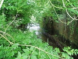
as a main drainage channel. The remains of the lower five lock chambers and the abutments of the tow-path bridge where the River Ancholme towpath crossed the canal are now grade II listed structures.. Despite being closed, two narrowboats successfully reached the first lock in 2002.
As a response to the flooding of homes in South Kelsey
during the summer of 2007, the Environment Agency
dredged part of the canal to return it to its original depth in March 2010. Around 1 miles (1.6 km) of the bed, between the locks either side of South Kelsey village, was affected by the work, which increases the capacity of the watercourse and reduces the risk of future flooding. The channel had been impeded by several sand bars that had developed, and these were removed as part of the project. Environmental consultants assisted with the work, to ensure that the resident population of water voles
were not harmed by the operation.
Canal
Canals are man-made channels for water. There are two types of canal:#Waterways: navigable transportation canals used for carrying ships and boats shipping goods and conveying people, further subdivided into two kinds:...
in Lincolnshire
Lincolnshire
Lincolnshire is a county in the east of England. It borders Norfolk to the south east, Cambridgeshire to the south, Rutland to the south west, Leicestershire and Nottinghamshire to the west, South Yorkshire to the north west, and the East Riding of Yorkshire to the north. It also borders...
, England
England
England is a country that is part of the United Kingdom. It shares land borders with Scotland to the north and Wales to the west; the Irish Sea is to the north west, the Celtic Sea to the south west, with the North Sea to the east and the English Channel to the south separating it from continental...
, constructed between 1793 and 1798. It fell into disuse sometime after 1850 and was legally abandoned in 1936. It ran from the River Ancholme
River Ancholme
The River Ancholme is a river in North Lincolnshire, England, and a tributary of the Humber estuary.It rises south of Bishopbridge and passes through many Lincolnshire villages and the market town of Brigg before flowing north into the Humber at South Ferriby.North of Bishopbridge, where the River...
, near South Kelsey
South Kelsey
South Kelsey is a village and civil parish in the West Lindsey district of Lincolnshire, England. It is on the B1205 between the A15 and Caistor.According to the 2001 census the village had a population of 571.South Kelsey has an Anglican church, St...
toward Caistor
Caistor
See Caistor St Edmund for the Roman settlement in Norfolk or Caister-on-Sea for the town in NorfolkCaistor is a town and civil parish situated in the West Lindsey district of Lincolnshire, England. As its name implies, it was originally a Roman castrum or fortress...
through six locks, terminating at Moortown
Moortown, Lincolnshire
Moortown is a hamlet within the civil parish of South Kelsey in the West Lindsey district of Lincolnshire, England. It is on the B1205 between the A15 and Caistor.-Location:...
, 3.5 miles (5.6 km) away from its intended terminus at Caistor. Parts of it were dredged in 2010, to aid flood defences in South Kelsey.
History
Water transport to the area served by the Caistor Canal were improved as a result of work carried out on the River AncholmeRiver Ancholme
The River Ancholme is a river in North Lincolnshire, England, and a tributary of the Humber estuary.It rises south of Bishopbridge and passes through many Lincolnshire villages and the market town of Brigg before flowing north into the Humber at South Ferriby.North of Bishopbridge, where the River...
between 1767 and 1769. The Caistor Canal was therefore conceived in July 1792 as a feeder to the river, enabling boats to reach the market town of Caistor
Caistor
See Caistor St Edmund for the Roman settlement in Norfolk or Caister-on-Sea for the town in NorfolkCaistor is a town and civil parish situated in the West Lindsey district of Lincolnshire, England. As its name implies, it was originally a Roman castrum or fortress...
, some 8 miles (12.9 km) to the east. An initial meeting was called by a Mr Hall on 3 July 1792, at which it was decided to ask the canal engineer William Jessop
William Jessop
William Jessop was an English civil engineer, best known for his work on canals, harbours and early railways in the late 18th and early 19th centuries.-Early life:...
to prepare a survey of the route. His plans were considered by the Ancholme Navigation Commissioners, in order to assess the risks of flooding caused by such a proposal. As they did not oppose the plans, the canal was authorised by an Act of Parliament
Act of Parliament
An Act of Parliament is a statute enacted as primary legislation by a national or sub-national parliament. In the Republic of Ireland the term Act of the Oireachtas is used, and in the United States the term Act of Congress is used.In Commonwealth countries, the term is used both in a narrow...
passed on 3 June 1793, which created the Caistor Canal Navigation Company, with powers to raise £15,000 in £100 shares to construct the canal, and an additional £10,000 if required.. The potential for flooding was to be mitigated by routing the local springs into the head of the canal. Robert Dickinson acted as engineer for the scheme.
Traffic consisted of coal inward, agricultural produce leaving the area, and general goods. There were six locks, which lowered the level of the canal by 42 feet (12.8 m). The Act authorised the building of the canal to Caistor, and a lane was constructed from the town centre to the site of the proposed basin, but the construction stopped at Moortown, some 3.5 miles (5.6 km) to the west. It is likely that financial problems were the reason for this, as the company borrowed £4,600 from Francis Foljambe, one of the principal promoters of the canal and the major landowner on its route, in 1798, and income from the tolls was not sufficient even to pay the interest, for there were £574 of arrears on the loan by 1813.
Soon after it opened, there were proposals to extend the canal to Market Rasen
Market Rasen
Market Rasen is a town and civil parish within the West Lindsey district of Lincolnshire, England. It lies on the River Rase northeast of Lincoln, east of Gainsborough and southwest of Grimsby. According to the 2001 census, it has a population of 3,200....
, but no further action was taken. The canal appears to have become disused in the 1850s, but some traffic may have continued to South Kelsey, the village at its mid-point until some years later. It was formally abandoned with the passing of the Caistor Canal Act Revocation Order made in 1936 under the land drainage act.
Mill lock was the site of a water mill from the 1870s until a little before the First World War. The mill was built on the south bank of the lock, with the wheel in the lock chamber. The lock name is thought to derive from a previous windmill near the site, rather than the corn mill, which was not built until the canal was disused.
Number of locks
There were originally six locks on the canal, according to Priestley. Boyes and Russell acknowledge that Priestley thought there were six, but state that he was wrong and that there were only five. However, the 1824 old series 2-inch map shows and labels the final lock just to the west of Moorhouse basin. By the time of the 1887 County series 25-inch maps, the final basin and the canal to the west of the lock are still shown, but there is a break in the canal where the lock was, so it appears to have been filled in by then.Today
The canal is no longer navigable, and is maintained by the Environment AgencyEnvironment Agency
The Environment Agency is a British non-departmental public body of the Department for Environment, Food and Rural Affairs and an Assembly Government Sponsored Body of the Welsh Assembly Government that serves England and Wales.-Purpose:...
as a main drainage channel. The remains of the lower five lock chambers and the abutments of the tow-path bridge where the River Ancholme towpath crossed the canal are now grade II listed structures.. Despite being closed, two narrowboats successfully reached the first lock in 2002.
As a response to the flooding of homes in South Kelsey
South Kelsey
South Kelsey is a village and civil parish in the West Lindsey district of Lincolnshire, England. It is on the B1205 between the A15 and Caistor.According to the 2001 census the village had a population of 571.South Kelsey has an Anglican church, St...
during the summer of 2007, the Environment Agency
Environment Agency
The Environment Agency is a British non-departmental public body of the Department for Environment, Food and Rural Affairs and an Assembly Government Sponsored Body of the Welsh Assembly Government that serves England and Wales.-Purpose:...
dredged part of the canal to return it to its original depth in March 2010. Around 1 miles (1.6 km) of the bed, between the locks either side of South Kelsey village, was affected by the work, which increases the capacity of the watercourse and reduces the risk of future flooding. The channel had been impeded by several sand bars that had developed, and these were removed as part of the project. Environmental consultants assisted with the work, to ensure that the resident population of water voles
Arvicola
The water voles are large voles in the genus Arvicola. They are found in both aquatic and dry habitat through Europe and much of northern Asia...
were not harmed by the operation.
Route
See also
- Canals of the United KingdomCanals of the United KingdomThe canals of the United Kingdom are a major part of the network of inland waterways in the United Kingdom. They have a colourful history, from use for irrigation and transport, through becoming the focus of the Industrial Revolution, to today's role for recreational boating...
- History of the British canal systemHistory of the British canal systemThe British canal system of water transport played a vital role in the United Kingdom's Industrial Revolution at a time when roads were only just emerging from the medieval mud and long trains of pack horses were the only means of "mass" transit by road of raw materials and finished products The...