
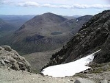
Cairn Toul
Encyclopedia
Cairn Toul is the fourth highest mountain in Scotland
, surpassed only by Ben Nevis
, Ben Macdui
and Braeriach
. It is the second highest point in the western massif of the Cairngorms
, linked by a bealach at around 1125 m above sea level to Braeriach.
The mountain
towers above the western side pass of the Lairig Ghru
.
Cairn Toul is often climbed on conjunction with other peaks. From the south, it may be combined with The Devil's Point
, which lies about 2.5 kilometres south-southeast. Alternatively, it may be climbed from the north, including Braeriach and Sgor an Lochain Uaine
. Both routes are long days by Scottish standards: around 15 km (plus return) regardless of whether one starts from Coire Cas above Speyside
, or Linn of Dee to the south.
The mountain may also be climbed from the west, starting from Achlean in Glen Feshie. This provides for a slighter shorter route (around 27 km for the round trip), though the walker must negotiate a large expanse of undulating bog
gy plateau
in order to reach the Breariach-Cairn Toul massif.
There is a bothy
, Corrour, at the point below Cairn Toul in the defile
of the Lairig Grhu.
Scotland
Scotland is a country that is part of the United Kingdom. Occupying the northern third of the island of Great Britain, it shares a border with England to the south and is bounded by the North Sea to the east, the Atlantic Ocean to the north and west, and the North Channel and Irish Sea to the...
, surpassed only by Ben Nevis
Ben Nevis
Ben Nevis is the highest mountain in the British Isles. It is located at the western end of the Grampian Mountains in the Lochaber area of the Scottish Highlands, close to the town of Fort William....
, Ben Macdui
Ben Macdhui (Scotland)
Ben Macdui is the second highest mountain in the United Kingdom after Ben Nevis, and the highest in the Cairngorms. After the defeat of Domnall mac Uilliam in 1187, Donnchad II, Earl of Fife, acquired Strathavon, territory stretching from Ballindalloch to Ben Macdui; because the mountain marked...
and Braeriach
Braeriach
Braeriach is the third highest mountain in Great Britain, surpassed only by Ben Nevis and Ben Macdui. It is the highest point in the western massif of the Cairngorms, separated from the central section by the pass of the Lairig Ghru. The summit has a crescent shape, with several corries...
. It is the second highest point in the western massif of the Cairngorms
Cairngorms
The Cairngorms are a mountain range in the eastern Highlands of Scotland closely associated with the mountain of the same name - Cairn Gorm.-Name:...
, linked by a bealach at around 1125 m above sea level to Braeriach.
The mountain
Mountain
Image:Himalaya_annotated.jpg|thumb|right|The Himalayan mountain range with Mount Everestrect 58 14 160 49 Chomo Lonzorect 200 28 335 52 Makalurect 378 24 566 45 Mount Everestrect 188 581 920 656 Tibetan Plateaurect 250 406 340 427 Rong River...
towers above the western side pass of the Lairig Ghru
Lairig Ghru
The Lairig Ghru is one of the mountain passes through the Cairngorms of Scotland.Like many traditional routes the ends of the route through the Lairig Ghru are like the ends of a frayed rope. From the south the Lairig Ghru can be approached from Braemar though Glen Lui, or Glen Dee, and from Blair...
.
Cairn Toul is often climbed on conjunction with other peaks. From the south, it may be combined with The Devil's Point
The Devil's Point
The Devil's Point is a mountain in the Cairngorms of Scotland, lying to the west of the Lairig Ghru pass. The name is derived from Gaelic, meaning "Penis of the Demon". The English name is a result of a visit to the area by Queen Victoria...
, which lies about 2.5 kilometres south-southeast. Alternatively, it may be climbed from the north, including Braeriach and Sgor an Lochain Uaine
Sgor an Lochain Uaine
Sgòr an Lochain Uaine is a mountain in the Cairngorms, Scotland. By some counts it is the fifth highest mountain in Scotland . It is the third highest point in the western massif of the Cairngorms, lying between Braeriach and Cairn Toul on the western side of the pass of the Lairig Ghru...
. Both routes are long days by Scottish standards: around 15 km (plus return) regardless of whether one starts from Coire Cas above Speyside
Speyside
Speyside can refer to:* Strathspey, Scotland, the famous whisky producing region by the River Spey** Speyside single malts, the type of whisky produced in Strathspey* Speyside, Trinidad and Tobago in Trinidad and Tobago...
, or Linn of Dee to the south.
The mountain may also be climbed from the west, starting from Achlean in Glen Feshie. This provides for a slighter shorter route (around 27 km for the round trip), though the walker must negotiate a large expanse of undulating bog
Bog
A bog, quagmire or mire is a wetland that accumulates acidic peat, a deposit of dead plant material—often mosses or, in Arctic climates, lichens....
gy plateau
Plateau
In geology and earth science, a plateau , also called a high plain or tableland, is an area of highland, usually consisting of relatively flat terrain. A highly eroded plateau is called a dissected plateau...
in order to reach the Breariach-Cairn Toul massif.
There is a bothy
Bothy
A bothy is a basic shelter, usually left unlocked and available for anyone to use free of charge. It was also a term for basic accommodation, usually for gardeners or other workers on an estate. Bothies are to be found in remote, mountainous areas of Scotland, northern England, Ireland, and Wales....
, Corrour, at the point below Cairn Toul in the defile
Defile (geography)
Defile is a geographic term for a narrow pass or gorge between mountains or hills. It has its origins as a military description of a pass through which troops can march only in a narrow column or with a narrow front...
of the Lairig Grhu.