
Cadder
Encyclopedia
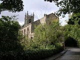
Cadder is a district of the town of Bishopbriggs
, East Dunbartonshire
, Scotland
. Located 7 km north of Glasgow city centre, 0.5 km south of the River Kelvin
, and approximately 1.5 km north-east of Bishopbriggs
town centre, sited on the route of the Forth and Clyde Canal
. It should not be confused with a City of Glasgow council housing scheme of a similar name, but generally pronounced Cawder, in the district of Lambhill
some 4 km to the west along the Canal, which was built in the early 1950s. Similarly, within Cadder, there is also Cawder Golf Club, which also uses this alternative pronunciation.
In antiquity, Cadder was the site of a Roman fort
on the route of the Antonine Wall
. Cadder House was a property held by the Stirling family
for generations.
Cadder has a large cemetery
and is also the site of Strathkelvin Retail Park.
Bishopbriggs
Bishopbriggs is a town in East Dunbartonshire, Scotland. The area was once part of the historic parish of Cadder - originally lands granted by King William the Lion to the Bishop of Glasgow, Jocelin, in 1180. It was later part of the county of Lanarkshire and subsequently an independent burgh from...
, East Dunbartonshire
East Dunbartonshire
This article is about the East Dunbartonshire council area of Scotland. See also East Dunbartonshire .East Dunbartonshire is one of the 32 council areas of Scotland. It borders onto the north-west of the City of Glasgow. It contains many of the suburbs of Glasgow as well as containing many of...
, Scotland
Scotland
Scotland is a country that is part of the United Kingdom. Occupying the northern third of the island of Great Britain, it shares a border with England to the south and is bounded by the North Sea to the east, the Atlantic Ocean to the north and west, and the North Channel and Irish Sea to the...
. Located 7 km north of Glasgow city centre, 0.5 km south of the River Kelvin
River Kelvin
The Kelvin rises on watershed of Scotland on the moor south east of the village of Banton, east of Kilsyth - . At almost 22 miles long, it initially flows south to Dullatur Bog where it falls into a man made trench and takes a ninety degree turn flowing west along the northern boundary of the bog...
, and approximately 1.5 km north-east of Bishopbriggs
Bishopbriggs
Bishopbriggs is a town in East Dunbartonshire, Scotland. The area was once part of the historic parish of Cadder - originally lands granted by King William the Lion to the Bishop of Glasgow, Jocelin, in 1180. It was later part of the county of Lanarkshire and subsequently an independent burgh from...
town centre, sited on the route of the Forth and Clyde Canal
Forth and Clyde Canal
The Forth and Clyde Canal crosses Scotland, providing a route for sea-going vessels between the Firth of Forth and the Firth of Clyde at the narrowest part of the Scottish Lowlands. The canal is 35 miles long and its eastern end is connected to the River Forth by a short stretch of the River...
. It should not be confused with a City of Glasgow council housing scheme of a similar name, but generally pronounced Cawder, in the district of Lambhill
Lambhill
Lambhill is a district in the Scottish city of Glasgow. It is situated north of the River Clyde.Lambhill is a mainly residential area comprising both council and private housing. Residents are of a mixed age group...
some 4 km to the west along the Canal, which was built in the early 1950s. Similarly, within Cadder, there is also Cawder Golf Club, which also uses this alternative pronunciation.
In antiquity, Cadder was the site of a Roman fort
Castra
The Latin word castra, with its singular castrum, was used by the ancient Romans to mean buildings or plots of land reserved to or constructed for use as a military defensive position. The word appears in both Oscan and Umbrian as well as in Latin. It may have descended from Indo-European to Italic...
on the route of the Antonine Wall
Antonine Wall
The Antonine Wall is a stone and turf fortification built by the Romans across what is now the Central Belt of Scotland, between the Firth of Forth and the Firth of Clyde. Representing the northernmost frontier barrier of the Roman Empire, it spanned approximately 39 miles and was about ten feet ...
. Cadder House was a property held by the Stirling family
Clan Stirling
-Origins of the Clan:The originator of the Clan Stirling is believed to be a man by the name of Thoraldus de Strivelyn vicecomes de Strivelyn who was granted a charter of lands in Cadder by King David I of Scotland in 1147...
for generations.
Cadder has a large cemetery
Cemetery
A cemetery is a place in which dead bodies and cremated remains are buried. The term "cemetery" implies that the land is specifically designated as a burying ground. Cemeteries in the Western world are where the final ceremonies of death are observed...
and is also the site of Strathkelvin Retail Park.