

Byker
Encyclopedia
Byker is an inner city
electoral ward
in the city of Newcastle upon Tyne
in Tyne and Wear
, England
. It is in the east of the city, south of the Heaton
area and north of St Peter's. Byker Metro station
serves the area.The area also contains the Byker Wall
estate. The population of the ward is 11,339, which is 4.4% of the city's total. Car ownership stands at 35.4%, much lower than the city average of 54.7%. Property prices in the ward average at £194,000.
Until the 1960s, Byker was a Victorian working-class area of densely-built terraces. Much of the housing needed major repair and some was considered unfit for human habitation (many houses lacked bathrooms), yet most residents wanted to stay in Byker, an area close to industry on the riverside. In the 1960s Newcastle City Corporation took the decision to redevelop the Byker area. The council aimed to clear the slums but keep the community.
Byker was extensively photographed before its demolition, primarily by Sirkka-Liisa Konttinen
, who lived in Byker from 1969. The photographs that Konttinen took toured China in 1980 and later appeared in the book Byker.
Architect Ralph Erskine was appointed as the architect in 1969 for the new Byker. The development was run as a "rolling programme" so local people could continue living in the area during the building work. Residents were involved in the design process and it is thought the outstanding success of Byker was as much to do with this as its innovative architecture.
Byker has suffered the kinds of the social problems common to other inner-city urban housing areas, including juvenile crime and vandalism. In parts of Byker turnover of tenancies has been high. Families have moved away - particularly those in employment. Some shops and services have been abandoned and boarded up. In the mid-1990s it has been estimated one in three of Byker's adult inhabitants was unemployed.
New leisure and shopping facilities have been brought to the Shields Road area. There are street wardens operating in Byker to deter vandalism and other low level crime. Education and employment initiatives aim to break the cycle of unemployment. There are also proposals to improve the fabric of the Byker area and the Ouseburn Valley in general.
Byker was the setting of the BBC TV
series Byker Grove
. However, the youth club featured in the series was actually The Mitre
in the Benwell
area in the west end of Newcastle.
word "kjerre" in modern Norwegian translates as "grove" in English.
 Most of these facilities are in the bordering ward of South Heaton such as the East End Pool & Library on Corbridge Street. Open green spaces in the ward are very limited. Byker ward also hosts the Byker in Bloom gardening competition which takes place in every summer. In 2008, Newcastle City Council agreed a lease of the former Byker (Shipley Street) Swimming Pool allowing it to be converted into an indoor bouldering and climbing centre.
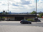 Byker is served by Byker Metro station
on the Tyne and Wear Metro
and Shields Road is served by numerous bus routes.
The ward has 5,794 housing spaces of which 8.7% are vacant. This is much higher than the city average of 5.3%. Owner occupied property stands at 31%, much lower than the city average of 53.3%. The properties are as follows.
Inner city
The inner city is the central area of a major city or metropolis. In the United States, Canada, United Kingdom and Ireland, the term is often applied to the lower-income residential districts in the city centre and nearby areas...
electoral ward
Wards of the United Kingdom
A ward in the United Kingdom is an electoral district at sub-national level represented by one or more councillors. It is the primary unit of British administrative and electoral geography .-England:...
in the city of Newcastle upon Tyne
Newcastle upon Tyne
Newcastle upon Tyne is a city and metropolitan borough of Tyne and Wear, in North East England. Historically a part of Northumberland, it is situated on the north bank of the River Tyne...
in Tyne and Wear
Tyne and Wear
Tyne and Wear is a metropolitan county in north east England around the mouths of the Rivers Tyne and Wear. It came into existence as a metropolitan county in 1974 after the passage of the Local Government Act 1972...
, England
England
England is a country that is part of the United Kingdom. It shares land borders with Scotland to the north and Wales to the west; the Irish Sea is to the north west, the Celtic Sea to the south west, with the North Sea to the east and the English Channel to the south separating it from continental...
. It is in the east of the city, south of the Heaton
Heaton, Newcastle
Heaton is a residential suburb and is split into two electoral wards located in the east end of Newcastle upon Tyne, England, about from the City Centre. It is bordered by the neighbouring areas of Benton and Cochrane Park to the north, Walker and Walkergate to the east, Byker to the south and...
area and north of St Peter's. Byker Metro station
Byker Metro station
Byker Metro station is located in Byker, an area in the east-end of Newcastle upon Tyne. The station is on the Yellow line of the Tyne and Wear Metro system, and opened in 1982...
serves the area.The area also contains the Byker Wall
Byker Wall
The Byker Wall is the name given to a long unbroken block of 620 maisonettes in the Byker district of Newcastle upon Tyne, England. The block was designed by the notable architect Ralph Erskine assisted by Vernon Gracie, and was built in the mid-1970s. The Wall, along with the low rise dwellings...
estate. The population of the ward is 11,339, which is 4.4% of the city's total. Car ownership stands at 35.4%, much lower than the city average of 54.7%. Property prices in the ward average at £194,000.
Until the 1960s, Byker was a Victorian working-class area of densely-built terraces. Much of the housing needed major repair and some was considered unfit for human habitation (many houses lacked bathrooms), yet most residents wanted to stay in Byker, an area close to industry on the riverside. In the 1960s Newcastle City Corporation took the decision to redevelop the Byker area. The council aimed to clear the slums but keep the community.
Byker was extensively photographed before its demolition, primarily by Sirkka-Liisa Konttinen
Sirkka-Liisa Konttinen
-Life and work:Born in Myllykoski Finland in 1948, Konttinen studied photography in London in the 1960s, and cofounded the Amber collective, which moved to Newcastle....
, who lived in Byker from 1969. The photographs that Konttinen took toured China in 1980 and later appeared in the book Byker.
Architect Ralph Erskine was appointed as the architect in 1969 for the new Byker. The development was run as a "rolling programme" so local people could continue living in the area during the building work. Residents were involved in the design process and it is thought the outstanding success of Byker was as much to do with this as its innovative architecture.
Byker has suffered the kinds of the social problems common to other inner-city urban housing areas, including juvenile crime and vandalism. In parts of Byker turnover of tenancies has been high. Families have moved away - particularly those in employment. Some shops and services have been abandoned and boarded up. In the mid-1990s it has been estimated one in three of Byker's adult inhabitants was unemployed.
New leisure and shopping facilities have been brought to the Shields Road area. There are street wardens operating in Byker to deter vandalism and other low level crime. Education and employment initiatives aim to break the cycle of unemployment. There are also proposals to improve the fabric of the Byker area and the Ouseburn Valley in general.
Byker was the setting of the BBC TV
BBC Television
BBC Television is a service of the British Broadcasting Corporation. The corporation, which has operated in the United Kingdom under the terms of a Royal Charter since 1927, has produced television programmes from its own studios since 1932, although the start of its regular service of television...
series Byker Grove
Byker Grove
Byker Grove was a British television series which aired between 1989 and 2006 and was created by Adele Rose. The show was broadcast at 5.10pm after Newsround on CBBC on BBC One...
. However, the youth club featured in the series was actually The Mitre
The Mitre, Newcastle upon Tyne
The Mitre is a building situated in the Benwell area in the west end of Newcastle upon Tyne, England. It is a Grade II listed building.A tower house known as Benwell Tower was built in 1221, and became the residence of the Bishop of Newcastle in the 1880s...
in the Benwell
Benwell
Benwell is an area in the West End of Newcastle upon Tyne, England.-History:Benwell village was recorded in A.D. 1050 known as Bynnewalle which roughly translates as "behind the wall" or "by the wall". Referring to its position relative to Hadrian's Wall...
area in the west end of Newcastle.
History
The place-name Byker means "settlement near marshy woodland" or "settlement near a church" and has Viking roots. The "by" part comes from the Norse "by", meaning "farmstead" or "village". The "ker" comes either from the Norse "kjerr" or "kir", where the former means "marshy woodland" and the latter is a contraction of "kirk", meaning "church". Coincidentally, theword "kjerre" in modern Norwegian translates as "grove" in English.
Education
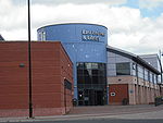
The ward has two primary schools, St. Lawrence RC Primary School and Byker Primary School, which is equipped with a nursery class.Recreation and leisure
Transport
Byker Metro station
Byker Metro station is located in Byker, an area in the east-end of Newcastle upon Tyne. The station is on the Yellow line of the Tyne and Wear Metro system, and opened in 1982...
on the Tyne and Wear Metro
Tyne and Wear Metro
The Tyne and Wear Metro, also known as the Metro, is a light rail system in North East England, serving Newcastle upon Tyne, Gateshead, South Tyneside, North Tyneside and Sunderland. It opened in 1980 and in 2007–2008 provided 40 million public journeys on its network of nearly...
and Shields Road is served by numerous bus routes.
Boundary
Byker ward stretches from the Fossway and Millers Road in the north of the ward to the banks of the River Tyne in the south. It heads south onto the Shields Road bypass (A187) and continues along the A193 bypass along Shields Road to the Ouse Burn. It turns south down the Ouse Burn to the River Tyne and follows the river east, turning northwards to the west of the properties on The Oval (and excluding the Bakewell Terrace properties). Heading east along Walker Road, the boundary then turns north up Staines Road and continues north through Kingston Avenue. It turns west along Dunstanburgh Road, and then north between Welbeck Primary School grounds and the properties on Allendale Road. It turns east along Welbeck Road, then north up Scrogg Road, east at Middle Street, and north along Langley Road. The boundary then runs along the gardens at the back of Whinneyfield Road before turning west down the Fossway.Charts and tables
| Age group | Number |
|---|---|
| Under 16 | 2,385 |
| 16-24 | 1,266 |
| 25-44 | 3,306 |
| 45-64 | 2,623 |
| 65-74 | 916 |
| 75+ | 844 |
| Ethnicity | Number | % |
|---|---|---|
| White | 10,897 | 95.9 |
| Afro-Caribbean | 49 | 0.4 |
| South Asian | 260 | 2.3 |
| Chinese | 40 | 0.4 |
| Other | 123 | 1.1 |
The ward has 5,794 housing spaces of which 8.7% are vacant. This is much higher than the city average of 5.3%. Owner occupied property stands at 31%, much lower than the city average of 53.3%. The properties are as follows.
| Property type | Number | % |
|---|---|---|
| Detached | 234 | 4 |
| Semi-detached | 1,170 | 20.1 |
| Terraced | 2,216 | 38.1 |
| Flats | 2,180 | 37.5 |
| Other | 0 | 0 |
See also
- Fly ash used for dressing footpaths in the area raised concerns over contamination by dioxins.
External links
- Photos of the area from Geograph
- Tim Pickford-Jones' Gallery of the Wall and Byker estate
- Kay's Geography guide to the Byker estate including current issues and photos
- Ouseburn Valley regeneration project
- Newcastle Council Ward Info: Byker
- Newcastle council 2001 census
Further reading
- Konttinen, Sirkka-Liisa. Byker. London: Jonathan Cape, 1983. ISBN 0224021095. Newcastle: Bloodaxe Books, 1985. ISBN 0906427908.
- Konttinen, Sirkka-Liisa. Byker Revisited. Newcastle upon Tyne: Northumberland University Press, 2009. ISBN 9781904794424.