Bury, West Sussex
Encyclopedia
Bury is a village
and civil parish
in the District of Chichester
in West Sussex
, England
located six kilometres (4 miles) south west of Pulborough
on the A29 road
.
The villages of Bury and nearby West Burton
are sited at the foot of the scarp slope
of the South Downs
, where springs from the chalk
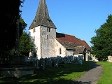
strata provided a constant supply of clean water. The Anglican parish church of St. John the Evangelist lies east of the village centre on the west bank of the River Arun
. The church is dominated by a 12th Century tower with a cedar
-shingled spire. There was formerly a passenger ferry by rowing boat to Amberley
on the east bank.
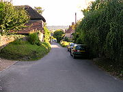
There are many old houses in the village and a large modern village hall. There is one pub, the Squire and Horse, beside the A29 road. Bury House close to the pub was the home of author John Galsworthy
for the final seven years of his life.
 West Burton, across some fields to the west, is similar in size to Bury and has many interesting old houses.
The parish has a land area of 1315 hectares (3247 acres). In the 2001 census 691 people lived in 264 households, of whom 319 were economically active.
Village
A village is a clustered human settlement or community, larger than a hamlet with the population ranging from a few hundred to a few thousand , Though often located in rural areas, the term urban village is also applied to certain urban neighbourhoods, such as the West Village in Manhattan, New...
and civil parish
Civil parish
In England, a civil parish is a territorial designation and, where they are found, the lowest tier of local government below districts and counties...
in the District of Chichester
Chichester (district)
Chichester is a largely rural local government district in West Sussex, England. Its council is based in the city of Chichester.-History:The district was formed on 1 April 1974, under the Local Government Act 1972, as a merger of the municipal borough of Chichester and the Rural Districts of...
in West Sussex
West Sussex
West Sussex is a county in the south of England, bordering onto East Sussex , Hampshire and Surrey. The county of Sussex has been divided into East and West since the 12th century, and obtained separate county councils in 1888, but it remained a single ceremonial county until 1974 and the coming...
, England
England
England is a country that is part of the United Kingdom. It shares land borders with Scotland to the north and Wales to the west; the Irish Sea is to the north west, the Celtic Sea to the south west, with the North Sea to the east and the English Channel to the south separating it from continental...
located six kilometres (4 miles) south west of Pulborough
Pulborough
Pulborough is a large village and civil parish in the Horsham district of West Sussex, England, with some 5,000 inhabitants. It is located almost centrally within West Sussex and is south west of London. It is at the junction of the north-south A29 and the east-west roads.The village is near the...
on the A29 road
A29 road
The A29 is a major road in England. It runs for approximately 34 miles from Capel, south of Dorking, leaving the A24, running through Billingshurst and Pulborough, crossing the South Downs at Bury Hill and passing Fontwell Park Racecourse before terminating on the B2166 on Bognor Regis sea...
.
The villages of Bury and nearby West Burton
West Burton, West Sussex
West Burton is a small village in the Chichester district of West Sussex, England. It lies on the Bignor to Bury road 4.5 miles southwest of Pulborough. It is one of a string of Saxon settlements at the foot of the South Downs escarpment where springs from the chalk strata provided clean reliable...
are sited at the foot of the scarp slope
Escarpment
An escarpment is a steep slope or long cliff that occurs from erosion or faulting and separates two relatively level areas of differing elevations.-Description and variants:...
of the South Downs
South Downs
The South Downs is a range of chalk hills that extends for about across the south-eastern coastal counties of England from the Itchen Valley of Hampshire in the west to Beachy Head, near Eastbourne, East Sussex, in the east. It is bounded on its northern side by a steep escarpment, from whose...
, where springs from the chalk
Chalk
Chalk is a soft, white, porous sedimentary rock, a form of limestone composed of the mineral calcite. Calcite is calcium carbonate or CaCO3. It forms under reasonably deep marine conditions from the gradual accumulation of minute calcite plates shed from micro-organisms called coccolithophores....
strata provided a constant supply of clean water. The Anglican parish church of St. John the Evangelist lies east of the village centre on the west bank of the River Arun
River Arun
The Arun is a river in the English county of West Sussex. Its source is a series of small streams in the St Leonard's Forest area, to the east of Horsham...
. The church is dominated by a 12th Century tower with a cedar
Cedar wood
Cedar wood comes from several different trees that grow in different parts of the world, and may have different uses.* California incense-cedar, from Calocedrus decurrens, is the primary type of wood used for making pencils...
-shingled spire. There was formerly a passenger ferry by rowing boat to Amberley
Amberley, West Sussex
Amberley is a village and civil parish in the Horsham District of West Sussex, England.Amberley is situated at the foot of the South Downs. Its neighbours are Storrington, West Chiltington and Arundel. The village is noted for its many thatched cottages...
on the east bank.
There are many old houses in the village and a large modern village hall. There is one pub, the Squire and Horse, beside the A29 road. Bury House close to the pub was the home of author John Galsworthy
John Galsworthy
John Galsworthy OM was an English novelist and playwright. Notable works include The Forsyte Saga and its sequels, A Modern Comedy and End of the Chapter...
for the final seven years of his life.

The parish has a land area of 1315 hectares (3247 acres). In the 2001 census 691 people lived in 264 households, of whom 319 were economically active.

