
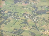
Burrawang, New South Wales
Encyclopedia
Burrawang is a village in the Southern Highlands
of New South Wales
, Australia
in Wingecarribee Shire. According to the 2006 Australian census, Burrawang's population was 177.
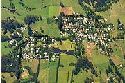 It is situated high on a hill, 760m above sea level, midway between two reservoirs, the Wingecarribee and the Fitzroy.

At the time of white settlement in New South Wales, the Wadi Wadi tribe of Aborigines
occupied the Burrawang (Yarrawa) area. The British naval surgeon Charles Throsby
(1777 - 1828), became settler in the colony in 1802 at the age of 31 and from 1804 served in the colonial medical establishment in the Newcastle area until 1809. He, along with his 58 year old assistant Joseph Wild
were mapping what is now known as the Moss Vale
and Sutton Forest area and were commissioned to find an overland route from there to Jervis Bay
as well as to plan and oversee the construction of a road to Goulburn Plains
.
Throsby became the first landowner in what is now the Southern Highlands area in 1819 developing a cattle station which is now a museum open for public inspection called Throsby Park just off the Illawarra Highway in Moss Vale. This extremely capable pioneer became a member of the Legislative Council in 1825.
Surveyor Robert Hoddle
and a gang of convicts cut a bridle path down the escarpment in 1830 as part of a track joining Cowpastures (Camden
) to Kiama
and Gerringong
.
Sometime during this era the natural attributes of the Yarrawa Brush region came to their attention with its exotic rain forest and rich volcanic soil. This later became public knowledge and in 1859 the first land grant was issued in what is now the pretty hamlet of Wildes Meadow (a derivative of the name Wild’s meadow).
In 1865 the first post office was established at Burrawang, which was named after the native palm once plentiful in the area. Shortly thereafter came the first school, originally an Anglican establishment, which in 1876 was replaced by the first public school at the ‘Old School House’ (now a private residence).
In what is now Church Street the three churches were established around this time; Catholic 1875, Anglican 1886 and Presbyterian in 1888 (now a residential dwelling).
Major industries at the time included dairying, potatoes, vegies plus flour and timber milling. Burrawang also had a newspaper; the Burrawang Herald and the hall boasted an active social calendar including an annual ball.
Burrawang remained the major development in the Yarrawa Brush for some years but Robertson took over sometime in the late 1880s with the advent of a more direct road to Moss Vale the neighboring development of Robertson started to overtake as the key settlement in the region. Once Macquarie Pass was opened in 1898, Burrawang became somewhat isolated.
. It is said to roam around at night. It is rumoured to kill cattle and if anyone wanted to capture the bunyip, it will disappear.
Southern Highlands, New South Wales
The Southern Highlands, also locally referred to as the Highlands, is a geographical region and district in New South Wales, Australia and is 110 km south-west of Sydney. The entire region is under the local government area of the Wingecarribee Shire...
of New South Wales
New South Wales
New South Wales is a state of :Australia, located in the east of the country. It is bordered by Queensland, Victoria and South Australia to the north, south and west respectively. To the east, the state is bordered by the Tasman Sea, which forms part of the Pacific Ocean. New South Wales...
, Australia
Australia
Australia , officially the Commonwealth of Australia, is a country in the Southern Hemisphere comprising the mainland of the Australian continent, the island of Tasmania, and numerous smaller islands in the Indian and Pacific Oceans. It is the world's sixth-largest country by total area...
in Wingecarribee Shire. According to the 2006 Australian census, Burrawang's population was 177.
History
At the time of white settlement in New South Wales, the Wadi Wadi tribe of Aborigines
Indigenous Australians
Indigenous Australians are the original inhabitants of the Australian continent and nearby islands. The Aboriginal Indigenous Australians migrated from the Indian continent around 75,000 to 100,000 years ago....
occupied the Burrawang (Yarrawa) area. The British naval surgeon Charles Throsby
Charles Throsby
Charles Throsby was an Australian explorer, pioneer and parliamentarian. He opened up much new land beyond the Blue Mountains for colonial settlement. He was a grazier, and became a prominent member of New South Wales society.- Early life :...
(1777 - 1828), became settler in the colony in 1802 at the age of 31 and from 1804 served in the colonial medical establishment in the Newcastle area until 1809. He, along with his 58 year old assistant Joseph Wild
Joseph Wild
Joseph Wild was an early explorer of Australia. He was sentenced on 21 August 1793 in Chester for burglary, together with his brother, George. Both were transported to Australia as convicts in 1797, arriving in Port Jackson on the ship the Ganges on 2 June...
were mapping what is now known as the Moss Vale
Moss Vale, New South Wales
Moss Vale is a town in the Southern Highlands of New South Wales, Australia, in Wingecarribee Shire. It has a population of 7,339 and is sited on the Illawarra Highway, which connects to Wollongong and the Illawarra coast via Macquarie Pass...
and Sutton Forest area and were commissioned to find an overland route from there to Jervis Bay
Jervis Bay
Jervis Bay is a large bay bounded by the state of New South Wales, the Jervis Bay Territory, and a detached enclave of the Australian Capital Territory. HMAS Creswell is located between Jervis Bay Village and Greenpatch in the Jervis Bay Territory.-History:...
as well as to plan and oversee the construction of a road to Goulburn Plains
Goulburn, New South Wales
Goulburn is a provincial city in the Southern Tablelands of New South Wales, Australia in Goulburn Mulwaree Council Local Government Area. It is located south-west of Sydney on the Hume Highway and above sea-level. On Census night 2006, Goulburn had a population of 20,127 people...
.
Throsby became the first landowner in what is now the Southern Highlands area in 1819 developing a cattle station which is now a museum open for public inspection called Throsby Park just off the Illawarra Highway in Moss Vale. This extremely capable pioneer became a member of the Legislative Council in 1825.
Surveyor Robert Hoddle
Robert Hoddle
Robert Hoddle was a surveyor of Port Phillip in the 1830s, and the creator of the Hoddle Grid, the street grid system upon which inner city Melbourne is based. He was also an accomplished artist and depicted scenes of the Port Philip region as well as New South Wales...
and a gang of convicts cut a bridle path down the escarpment in 1830 as part of a track joining Cowpastures (Camden
Camden, New South Wales
-Education:Camden is the location of research facilities for the veterinary and agricultural schools of the University of Sydney. The local government area has two public high schools, Camden High School and Elderslie High School, as well as eight Catholic and three Anglican schools.-Culture:The...
) to Kiama
Kiama, New South Wales
-Transport:The town is served by Kiama Station on the South Coast Line. It is served by road in the form of the Princes Highway and the Kiama Bypass.-Attractions:...
and Gerringong
Gerringong, New South Wales
Gerringong is a town located about 10 minutes south of Kiama in the Illawarra region of New South Wales, Australia in the Municipality of Kiama. At the 2006 census, Gerringong had a population of 3,588 people.One theory says that the name derives from an Aboriginal word meaning "fearful...
.
Sometime during this era the natural attributes of the Yarrawa Brush region came to their attention with its exotic rain forest and rich volcanic soil. This later became public knowledge and in 1859 the first land grant was issued in what is now the pretty hamlet of Wildes Meadow (a derivative of the name Wild’s meadow).
In 1865 the first post office was established at Burrawang, which was named after the native palm once plentiful in the area. Shortly thereafter came the first school, originally an Anglican establishment, which in 1876 was replaced by the first public school at the ‘Old School House’ (now a private residence).
In what is now Church Street the three churches were established around this time; Catholic 1875, Anglican 1886 and Presbyterian in 1888 (now a residential dwelling).
Major industries at the time included dairying, potatoes, vegies plus flour and timber milling. Burrawang also had a newspaper; the Burrawang Herald and the hall boasted an active social calendar including an annual ball.
Burrawang remained the major development in the Yarrawa Brush for some years but Robertson took over sometime in the late 1880s with the advent of a more direct road to Moss Vale the neighboring development of Robertson started to overtake as the key settlement in the region. Once Macquarie Pass was opened in 1898, Burrawang became somewhat isolated.
Mythology of the Burrawang Bunyip
There is a swamp outside the town that is home to the legendary Burrawang BunyipBunyip
The bunyip, or kianpraty, is a large mythical creature from Aboriginal mythology, said to lurk in swamps, billabongs, creeks, riverbeds, and waterholes....
. It is said to roam around at night. It is rumoured to kill cattle and if anyone wanted to capture the bunyip, it will disappear.
External links
- Official website
- http://www.highlandsnsw.com.au/towns/burrawang.html