Burgess Falls State Park
Encyclopedia
State park
State parks are parks or other protected areas managed at the federated state level within those nations which use "state" as a political subdivision. State parks are typically established by a state to preserve a location on account of its natural beauty, historic interest, or recreational...
and state natural area in Putnam County
Putnam County, Tennessee
Putnam County is a county located in the U.S. state of Tennessee. As of 2000, the population was 62,315, a 21 percent increase from 1990. The was 72,321, an increase of 16.1% since 2000...
and White County, Tennessee
White County, Tennessee
White County is a county located in the U.S. state of Tennessee. As of 2000, the population was 23,102. Its county seat is Sparta.-History:...
, located in the southeastern United States. The park is situated around a steep gorge in which the Falling Water River
Falling Water River
The Falling Water River is a stream in the east-central portion of Middle Tennessee in the United States. It is a tributary of the Caney Fork of the Cumberland River. By the Cumberland and Ohio rivers, it is part of the Mississippi River watershed....
drops 250 feet (76.2 m) in elevation in less than a mile, culminating in a 136 feet (41.5 m) cataract waterfall
Waterfall
A waterfall is a place where flowing water rapidly drops in elevation as it flows over a steep region or a cliff.-Formation:Waterfalls are commonly formed when a river is young. At these times the channel is often narrow and deep. When the river courses over resistant bedrock, erosion happens...
.
The Burgess Falls State Natural Area, which covers 350 acres (1.4 km²), is managed by the Tennessee Department of Environment and Conservation
Tennessee Department of Environment and Conservation
The Tennessee Department of Environment and Conservation is a Cabinet-level agency within the government of the U.S. state of Tennessee, headed by the Tennessee Commissioner of Environment and Conservation....
.
Geography

Highland Rim
The Highland Rim is a geographic term for the area in Tennessee surrounding the Central Basin. Nashville is largely surrounded by higher terrain in all directions....
to its mouth along the Center Hill Lake
Center Hill Lake
Center Hill Lake is a reservoir in the U.S. state of Tennessee. It is located in Middle Tennessee near Smithville. Created by means of a dam constructed by the U.S. Army Corps of Engineers in 1948, the lake had a dual purpose: electricity production and flood control...
impoundment of the Caney Fork, which is located in an area where the Highland Rim drops off into the Central Basin
Nashville Basin
The Nashville Basin, also known as the Central Basin, is a term often used to describe the area surrounding Nashville, Tennessee. The Central Basin was caused by an uplifting known as the Nashville Dome. The Nashville Dome is evidenced by the underlying rock strata that all dip downwards away from...
. The Burgess Falls State Natural Area comprises the section of the river just above its mouth, where the river drops from roughly 900 feet (274.3 m) atop the Highland Rim to just over 600 feet (182.9 m) at Center Hill Lake. (Click for map)
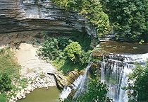
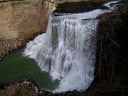
Over time, the Falling Water River's rapids have cut a deep gorge just above its mouth. The river drops to the Central Basin in a series of cascades and waterfalls, each gaining in size and intensity as the river approaches Center Hill Lake. At the Falling Water Cascades, located just downstream from the old Burgess Falls Dam, the river gradually spills over a 10 feet (3 m) embankment of rocks. Almost immediately downstream from the Cascades, the river drops another 30 feet (9.1 m) at Little Falls. Beyond Little Falls, where the river briefly bends to the north, is an 80 feet (24.4 m) cascade known as Middle Falls. Downstream from Middle Falls, where the river bends westward again, is the 136 feet (41.5 m) Burgess Falls
Burgess Falls
Burgess Falls spills into a large limestone gorge enclosed by sheer 100–200 foot walls. The Falling Water River enters Center Hill Lake roughly a mile downstream from Burgess Falls. The falls are located within the Burgess Falls State Park....
. The distance between Falling Water Cascades and Burgess Falls is less than a mile. Burgess Falls spills into a large limestone gorge enclosed by sheer 100-200 foot walls. The Falling Water River enters Center Hill Lake roughly a mile downstream from Burgess Falls.
History
Burgess Falls is named after Tom Burgess, a Revolutionary WarAmerican Revolutionary War
The American Revolutionary War , the American War of Independence, or simply the Revolutionary War, began as a war between the Kingdom of Great Britain and thirteen British colonies in North America, and ended in a global war between several European great powers.The war was the result of the...
veteran who settled along this section of the Falling Water River in the 1790s. The Burgess family used the river's rapids to power a grist mill
Gristmill
The terms gristmill or grist mill can refer either to a building in which grain is ground into flour, or to the grinding mechanism itself.- Early history :...
and eventually a saw mill which supplied early settlers with corn meal and lumber.
In 1924, the City of Cookeville
Cookeville, Tennessee
Cookeville is a city in Putnam County, Tennessee, United States. The population was 23,923 at the 2000 census. of Cookeville's population was 30,435, and the combined total of those living in Cookeville's in 2010 was 65,014. It is the county seat of Putnam County and home to Tennessee...
built an earthen dam along the river a mile or so upstream from Burgess Falls. After a flood destroyed the dam in 1928, the city replaced it with a concrete dam that provided the area with electricity until the arrival of the Tennessee Valley Authority
Tennessee Valley Authority
The Tennessee Valley Authority is a federally owned corporation in the United States created by congressional charter in May 1933 to provide navigation, flood control, electricity generation, fertilizer manufacturing, and economic development in the Tennessee Valley, a region particularly affected...
in 1944. Due in large part to calls from Cookevillians to protect the area, Burgess Falls State Park was established in 1971. Part of a pipeline bridge still spans the river in the vicinity of Little Falls. The pipeline originally crossed the river into a tunnel on the north walls of the gorge and emerged to cross the river again near Middle Falls en route to a powerhouse.
Access

A 1.5 miles (2.4 km) loop trail follows the bluffs along the south bank of the gorge, starting at Falling Water Cascades and ending at a platform overlooking Burgess Falls
Burgess Falls
Burgess Falls spills into a large limestone gorge enclosed by sheer 100–200 foot walls. The Falling Water River enters Center Hill Lake roughly a mile downstream from Burgess Falls. The falls are located within the Burgess Falls State Park....
. Little Falls and Middle Falls are also visible from the trail. A stairway leads down to the overhang of Burgess Falls and continues down into the gorge. A second loop trail follows the ridgeline southwest of Burgess Falls.
The Burgess Falls State Natural Area includes Burgess Falls Lake and part of the forest on the both sides of the river in the lake's vicinity.
External links