
Bunia
Encyclopedia
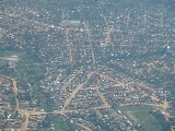
Bunia is a city in Democratic Republic of the Congo
(DRC) and is the headquarters of Ituri Interim Administration
in the Ituri region of Orientale Province
.
It lies at an elevation of 1275 m on a plateau about 30 km west of Lake Albert in the Great Rift Valley
, and about 25 km east of the Ituri Forest.
The city is at the center of the Ituri conflict
between the Lendu
and Hema
. In the Second Congo War
the city and district were the scene of much fighting and many civilian deaths from this conflict, and related clashes between militia
s and Uganda
-based forces. Consequently the city is the base of one of the largest United Nations peace-keeping forces in Africa, and its headquarters in northeastern DRC. The area's natural resources include gold mines over which militias and foreign forces have been fighting.
to the west and Butembo
and Goma
to the south pass through Bunia, but have fallen into disrepair and are virtually impassable, especially after the frequent rains.
Bunia is only 40 km from the Ugandan border running down Lake Albert, but there are no road connections across the Great Rift Valley to the closest Ugandan towns of Toro and Fort Portal
. Instead a dirt highway going north-east reaches Arua
and Gulu
north of the lake. Before the war made the route impassable, this was the chief trade route between the DRC and Uganda, as well between the DRC and Juba
in Sudan
, and Bunia was an important market city, for cross-border trade as well as internal trade.
The supposed route of the Lagos-Mombasa Highway
passes just to the south of Bunia, emphasising its potential as a centre of trade, but that transnational highway does not exist as a viable route through the DRC.
Bunia is linked to the small port of Kisenye on Lake Albert by a 60-kilometre dirt track via Bogoro, which has a spectacular and dangerous 600-metre descent of the western escarpment of the Great Rift Valley. Kisenye has a 100 m jetty from which boat transport can link with Mahagi-Port at the north end of the lake, and with Butiaba
on the Ugandan side and Pakwach
on the Albert Nile.
Given the poor state of the roads, and the total lack of railway transport, Bunia Airport
is of prime importance.
Although Bunia is about 170 km north of the Equator, the city was featured in the BBC television
travel documentary Equator
made in 2006, since it was one of the few places near the Equator in eastern DRC where the safety of the TV crew could be assured, by the presence of the large UN peace-keeping force.
Democratic Republic of the Congo
The Democratic Republic of the Congo is a state located in Central Africa. It is the second largest country in Africa by area and the eleventh largest in the world...
(DRC) and is the headquarters of Ituri Interim Administration
Ituri Interim Administration
The Ituri Interim Administration is an interim body that administers the Ituri region of the Democratic Republic of Congo. It was established in 2003 by the Ituri Pacification Commission and supported by the UN mission in the DRC.-History:...
in the Ituri region of Orientale Province
Orientale, Congo
Orientale is one of the ten provinces of the Democratic Republic of the Congo. The province lies in the northeast of the country. It borders Équateur province to the west, Kasai-Oriental province to the southwest, Maniema province to the south, and Nord-Kivu province to the southeast...
.
It lies at an elevation of 1275 m on a plateau about 30 km west of Lake Albert in the Great Rift Valley
Great Rift Valley
The Great Rift Valley is a name given in the late 19th century by British explorer John Walter Gregory to the continuous geographic trench, approximately in length, that runs from northern Syria in Southwest Asia to central Mozambique in South East Africa...
, and about 25 km east of the Ituri Forest.
The city is at the center of the Ituri conflict
Ituri Conflict
The Ituri conflict is a conflict between the agriculturalist Lendu and pastoralist Hema ethnic groups in the Ituri region of the northeastern Democratic Republic of Congo . While there have been many phases to the conflict, the most recent armed clashes ran from 1999 to 2003, with a low-level...
between the Lendu
Lendu
The Lendu, or Balendru, are an ethno-linguistic agriculturalist group residing in eastern Democratic Republic of Congo in the area west and northwest of Lake Albert, in particular the Ituri region of Orientale province. Their language is one of the most populous of the Central Sudanic languages...
and Hema
Hema people
The Hema, or Hima, are an ethnic group with about 160,000 members located in the eastern Democratic Republic of the Congo, in particular the Ituri region and Orientale province, as well as parts of Uganda and Rwanda...
. In the Second Congo War
Second Congo War
The Second Congo War, also known as Coltan War and the Great War of Africa, began in August 1998 in the Democratic Republic of the Congo , and officially ended in July 2003 when the Transitional Government of the Democratic Republic of the Congo took power; however, hostilities continue to this...
the city and district were the scene of much fighting and many civilian deaths from this conflict, and related clashes between militia
Militia
The term militia is commonly used today to refer to a military force composed of ordinary citizens to provide defense, emergency law enforcement, or paramilitary service, in times of emergency without being paid a regular salary or committed to a fixed term of service. It is a polyseme with...
s and Uganda
Uganda
Uganda , officially the Republic of Uganda, is a landlocked country in East Africa. Uganda is also known as the "Pearl of Africa". It is bordered on the east by Kenya, on the north by South Sudan, on the west by the Democratic Republic of the Congo, on the southwest by Rwanda, and on the south by...
-based forces. Consequently the city is the base of one of the largest United Nations peace-keeping forces in Africa, and its headquarters in northeastern DRC. The area's natural resources include gold mines over which militias and foreign forces have been fighting.
Transport
The main dirt highways connecting north-eastern DR Congo with KisanganiKisangani
Kisangani is the capital of Orientale Province in the Democratic Republic of the Congo. It is the 3rd largest urbanized city in the country and the largest of the cities that lie in the tropical woodlands of the Congo....
to the west and Butembo
Butembo
Butembo is a city in North Kivu, in the north eastern Democratic Republic of Congo, lying west of the Virunga National Park. Until the Congo Civil War, it was an important commercial centre with a large market, a cathedral, a small hospital, and an airport, lying in an area known for tea and...
and Goma
Goma
Goma is a city in the eastern Democratic Republic of the Congo, on the northern shore of Lake Kivu, next to the Rwandan city of Gisenyi. The lake and the two cities are in the western branch of the Great Rift Valley, and Goma lies only 13 to 18 km due south of the crater of the active...
to the south pass through Bunia, but have fallen into disrepair and are virtually impassable, especially after the frequent rains.
Bunia is only 40 km from the Ugandan border running down Lake Albert, but there are no road connections across the Great Rift Valley to the closest Ugandan towns of Toro and Fort Portal
Fort Portal
Fort Portal is a town in Western Uganda. It is the seat of both Kabarole District and Toro Kingdom.-Location:Fort Portal is located approximately by road, west of Kampala, Uganda's capital and largest city, on an all-tarmac two-lane highway...
. Instead a dirt highway going north-east reaches Arua
Arua
Arua is a town in Arua District, Northern Uganda. An important local commercial centre, it is a base for a large refugee population from Southern Sudan and the Democratic Republic of the Congo and is an aid distribution centre for those nations.-Location:...
and Gulu
Gulu
Gulu is a city in Northern Uganda. It is the commercial and administrative centre of Gulu District. The city is located at 2˚46'48N 32˚18'00E, on the metre gauge railway from Tororo to Pakwach. Gulu is located approximately , by road, north of Kampala, Uganda's capital and largest city...
north of the lake. Before the war made the route impassable, this was the chief trade route between the DRC and Uganda, as well between the DRC and Juba
Juba, Sudan
Juba is the capital and largest city of the Republic of South Sudan. It also serves as the capital of Central Equatoria, the smallest of the ten states of South Sudan. The city is situated on the White Nile and functions as the seat and metropolis of Juba County.- Population :In 2005, Juba's...
in Sudan
Sudan
Sudan , officially the Republic of the Sudan , is a country in North Africa, sometimes considered part of the Middle East politically. It is bordered by Egypt to the north, the Red Sea to the northeast, Eritrea and Ethiopia to the east, South Sudan to the south, the Central African Republic to the...
, and Bunia was an important market city, for cross-border trade as well as internal trade.
The supposed route of the Lagos-Mombasa Highway
Lagos-Mombasa Highway
The Lagos-Mombasa Highway is Trans-African Highway 8 and is principal road route between West and East Africa...
passes just to the south of Bunia, emphasising its potential as a centre of trade, but that transnational highway does not exist as a viable route through the DRC.
Bunia is linked to the small port of Kisenye on Lake Albert by a 60-kilometre dirt track via Bogoro, which has a spectacular and dangerous 600-metre descent of the western escarpment of the Great Rift Valley. Kisenye has a 100 m jetty from which boat transport can link with Mahagi-Port at the north end of the lake, and with Butiaba
Butiaba
Butiaba, sometimes spelled as Butyaba, is a town in Western Uganda.-Location:Butiaba is situated on the eastern shores of Lake Albert, in Masindi District. It is located approximately , by road, west of the district headquarters at Masindi. This location is approximately , by road, northwest of...
on the Ugandan side and Pakwach
Pakwach
- Location :Pakwach is located in Nebbi District, in West Nile sub-region, in Northern Uganda. It is situated approximately , by road, southeast of Arua, the largest town in West Nile. This location lies along the western bank of the Albert Nile, approximately , by road, southwest of Gulu, the...
on the Albert Nile.
Given the poor state of the roads, and the total lack of railway transport, Bunia Airport
Bunia Airport
Bunia Airport is an airport in Bunia, Democratic Republic of the Congo.-Airlines and destinations:...
is of prime importance.
Other features in the locality
Mount Hoyo is 35 km south-west of Bunia. The Shari River flows along the north-western outskirts of the city. The Ituri River flows around 35 km west of Bunia. The confluence of the Shari and Ituri is about 45 km south-southwest of Bunia.Although Bunia is about 170 km north of the Equator, the city was featured in the BBC television
BBC Television
BBC Television is a service of the British Broadcasting Corporation. The corporation, which has operated in the United Kingdom under the terms of a Royal Charter since 1927, has produced television programmes from its own studios since 1932, although the start of its regular service of television...
travel documentary Equator
Equator (BBC TV series)
Equator is a BBC television documentary series in three parts charting presenter Simon Reeve's journey along the Equator through Africa, Asia and South America....
made in 2006, since it was one of the few places near the Equator in eastern DRC where the safety of the TV crew could be assured, by the presence of the large UN peace-keeping force.
External links
- Detailed Map of Bunia
- Map of tribal areas of Ituri
- Congo's battle with disarmament, BBCBBCThe British Broadcasting Corporation is a British public service broadcaster. Its headquarters is at Broadcasting House in the City of Westminster, London. It is the largest broadcaster in the world, with about 23,000 staff...
, 9 June 2005 - Watch Equator, the BBC TV program featuring Bunia