
Brough, Cumbria
Encyclopedia
Brough, sometimes known as Brough under Stainmore, is a village and civil parish
in the Eden
district of Cumbria
, England
, on the western fringe of the Pennines
near Stainmore
. The village is on the A66
trans-Pennine road, and the Swindale Beck, and is about 8 miles (12.9 km) south east of Appleby-in-Westmorland
. Brough is situated 5 miles (8 km) north east of Kirkby Stephen
and 28 miles (45.1 km) north east of Kendal
on the A685
.
Brough lies within the historic boundaries of the ancient county
of Westmorland
. At the 2001 census it had a population of 680.
The village is on the site of the Roman
fort of Verterae, or Verteris, on the Roman road linking Carlisle with Ermine Street
. The area of the rectangular fort, which once occupied the land to the south of the Swindale Beck, is now a Scheduled Ancient Monument
http://www.magic.gov.uk/website/magic/viewer.htm?startTopic=magicall&chosenLayers=moncIndex&xygridref=379156,514061&startScale=10001. Brough Castle
was originally built in the 11th century within the northern part of the former fort.
Brough has historically been divided into Market Brough, to the north, and Church Brough, to the south and centred on the castle and St Michael's Church. In 1977 this division was made physical by the construction of the Brough bypass dual carriageway, taking the A66 away from the village main street.
St Michael's Church also dates back to the Norman
period, and may have suffered during William I of Scotland
's attack on the castle in 1174. The church was enlarged in the 14th century, and again in the early 16th, when most of the existing structure was built. The tower was constructed by Thomas Blenkinsop of Helbeck in 1513. Repairs and improvements continue to this day.
Further information can be found at http://myweb.tiscali.co.uk/magorrian/church/
Nearby is Augill Castle, built in 1841 by John Bagot Pearson from Kirkby Lonsdale as a weekend retreat and now a hotel.
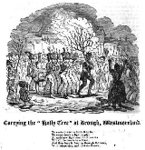
Traditionally, on Twelfth Night, a burning holly tree (subsequently, ash tree
s were used) would be carried through the village, followed by a brass band. When the flames had partially gone out, the villagers would try to bring the tree to a pub, where the party would continue until the early hours of the morning. The village was also the venue for a popular fair on the second Thursday of March.

Civil parish
In England, a civil parish is a territorial designation and, where they are found, the lowest tier of local government below districts and counties...
in the Eden
Eden, Cumbria
Eden is a local government district in Cumbria, England. Its council is based in Penrith. It is named after the River Eden which flows north through the district toward Carlisle....
district of Cumbria
Cumbria
Cumbria , is a non-metropolitan county in North West England. The county and Cumbria County Council, its local authority, came into existence in 1974 after the passage of the Local Government Act 1972. Cumbria's largest settlement and county town is Carlisle. It consists of six districts, and in...
, England
England
England is a country that is part of the United Kingdom. It shares land borders with Scotland to the north and Wales to the west; the Irish Sea is to the north west, the Celtic Sea to the south west, with the North Sea to the east and the English Channel to the south separating it from continental...
, on the western fringe of the Pennines
Pennines
The Pennines are a low-rising mountain range, separating the North West of England from Yorkshire and the North East.Often described as the "backbone of England", they form a more-or-less continuous range stretching from the Peak District in Derbyshire, around the northern and eastern edges of...
near Stainmore
Stainmore
Stainmore is a civil parish in the Eden District of Cumbria, England, including the villages of North Stainmore and South Stainmore. It has a population of 253.- Geography :...
. The village is on the A66
A66 road
The A66 is a major road in northern England which in part follows the course of the Roman road from Scotch Corner to Penrith. It runs from east of Middlesbrough in the ceremonial county of North Yorkshire to Workington in Cumbria...
trans-Pennine road, and the Swindale Beck, and is about 8 miles (12.9 km) south east of Appleby-in-Westmorland
Appleby-in-Westmorland
Appleby-in-Westmorland is a town and civil parish in Cumbria, in North West England. It is situated within a loop of the River Eden and has a population of approximately 2,500. It is in the historic county of Westmorland, of which it was the county town. The town's name was simply Appleby, until...
. Brough is situated 5 miles (8 km) north east of Kirkby Stephen
Kirkby Stephen
Kirkby Stephen is a civil parish and small market town in Cumbria, in North West England which historically, is part of Westmorland. The town is located on the A685, surrounded by sparsely populated hill country, and about from the two nearest larger towns, Kendal and Penrith...
and 28 miles (45.1 km) north east of Kendal
Kendal
Kendal, anciently known as Kirkby in Kendal or Kirkby Kendal, is a market town and civil parish within the South Lakeland District of Cumbria, England...
on the A685
A685 road
The A685 is a road in Cumbria, England, that runs 28 miles from Kendal to Brough.-Route:The A685 begins in Kendal town centre off the A6. It heads in a north-easterly direction to the village of Tebay and junction 38 of the M6 motorway. From the M6 the A685 has primary status as it heads in an...
.
Brough lies within the historic boundaries of the ancient county
Counties of the United Kingdom
The counties of the United Kingdom are subnational divisions of the United Kingdom, used for the purposes of administrative, geographical and political demarcation. By the Middle Ages counties had become established as a unit of local government, at least in England. By the early 17th century all...
of Westmorland
Westmorland
Westmorland is an area of North West England and one of the 39 historic counties of England. It formed an administrative county from 1889 to 1974, after which the entirety of the county was absorbed into the new county of Cumbria.-Early history:...
. At the 2001 census it had a population of 680.
The village is on the site of the Roman
Roman Britain
Roman Britain was the part of the island of Great Britain controlled by the Roman Empire from AD 43 until ca. AD 410.The Romans referred to the imperial province as Britannia, which eventually comprised all of the island of Great Britain south of the fluid frontier with Caledonia...
fort of Verterae, or Verteris, on the Roman road linking Carlisle with Ermine Street
Ermine Street
Ermine Street is the name of a major Roman road in England that ran from London to Lincoln and York . The Old English name was 'Earninga Straete' , named after a tribe called the Earningas, who inhabited a district later known as Armingford Hundred, around Arrington, Cambridgeshire and Royston,...
. The area of the rectangular fort, which once occupied the land to the south of the Swindale Beck, is now a Scheduled Ancient Monument
Scheduled Ancient Monument
In the United Kingdom, a scheduled monument is a 'nationally important' archaeological site or historic building, given protection against unauthorized change. The various pieces of legislation used for legally protecting heritage assets from damage and destruction are grouped under the term...
http://www.magic.gov.uk/website/magic/viewer.htm?startTopic=magicall&chosenLayers=moncIndex&xygridref=379156,514061&startScale=10001. Brough Castle
Brough Castle
Brough Castle is a ruined castle in the village of Brough, Cumbria , England. It is currently administered by English Heritage. The Castle consists of a large mound, on which there is an extensive range of buildings, with a circular corner tower, and the remnants of an older four storey...
was originally built in the 11th century within the northern part of the former fort.
Brough has historically been divided into Market Brough, to the north, and Church Brough, to the south and centred on the castle and St Michael's Church. In 1977 this division was made physical by the construction of the Brough bypass dual carriageway, taking the A66 away from the village main street.
St Michael's Church also dates back to the Norman
Normans
The Normans were the people who gave their name to Normandy, a region in northern France. They were descended from Norse Viking conquerors of the territory and the native population of Frankish and Gallo-Roman stock...
period, and may have suffered during William I of Scotland
William I of Scotland
William the Lion , sometimes styled William I, also known by the nickname Garbh, "the Rough", reigned as King of the Scots from 1165 to 1214...
's attack on the castle in 1174. The church was enlarged in the 14th century, and again in the early 16th, when most of the existing structure was built. The tower was constructed by Thomas Blenkinsop of Helbeck in 1513. Repairs and improvements continue to this day.
Further information can be found at http://myweb.tiscali.co.uk/magorrian/church/
Nearby is Augill Castle, built in 1841 by John Bagot Pearson from Kirkby Lonsdale as a weekend retreat and now a hotel.
Traditionally, on Twelfth Night, a burning holly tree (subsequently, ash tree
Ash tree
Fraxinus is a genus flowering plants in the olive and lilac family, Oleaceae. It contains 45-65 species of usually medium to large trees, mostly deciduous though a few subtropical species are evergreen. The tree's common English name, ash, goes back to the Old English æsc, while the generic name...
s were used) would be carried through the village, followed by a brass band. When the flames had partially gone out, the villagers would try to bring the tree to a pub, where the party would continue until the early hours of the morning. The village was also the venue for a popular fair on the second Thursday of March.