
Brooks Peninsula Provincial Park
Encyclopedia
Brooks Peninsula Provincial Park is a provincial park
Provincial park
A provincial park is a park under the management of a provincial or territorial government in Canada.While provincial parks are not the same as national parks, their workings are very similar...
located on the west coast of Vancouver Island
Vancouver Island
Vancouver Island is a large island in British Columbia, Canada. It is one of several North American locations named after George Vancouver, the British Royal Navy officer who explored the Pacific Northwest coast of North America between 1791 and 1794...
in British Columbia
British Columbia
British Columbia is the westernmost of Canada's provinces and is known for its natural beauty, as reflected in its Latin motto, Splendor sine occasu . Its name was chosen by Queen Victoria in 1858...
, Canada
Canada
Canada is a North American country consisting of ten provinces and three territories. Located in the northern part of the continent, it extends from the Atlantic Ocean in the east to the Pacific Ocean in the west, and northward into the Arctic Ocean...
.
History
As a result of land-use planning for Vancouver Island, this former 28,780 hectareHectare
The hectare is a metric unit of area defined as 10,000 square metres , and primarily used in the measurement of land. In 1795, when the metric system was introduced, the are was defined as being 100 square metres and the hectare was thus 100 ares or 1/100 km2...
(71,117 acre
Acre
The acre is a unit of area in a number of different systems, including the imperial and U.S. customary systems. The most commonly used acres today are the international acre and, in the United States, the survey acre. The most common use of the acre is to measure tracts of land.The acre is related...
) recreation area (established in 1986) was upgraded in 1995 to a Class ‘A’ Provincial Park. In addition to this upgrade, 22,851 hectares (56,466 acres) known as the Brooks-Nasparti area, has been added to the park.
Geography
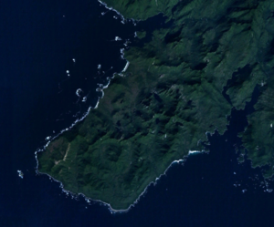
The park is 51,631 hectares (127,583 acres) in size. Brooks Peninsula is located about 20 kilometres (12 mi) southwest of Port Alice, British ColumbiaPort Alice, British Columbia
Port Alice is a small, quiet, town of approx. 821 located off on Neroutsos Inlet, northwest of Port McNeill, on Vancouver Island, originally built by Whalen Pulp and Paper Mills of Vancouver. The community is known for its natural beauty, pulp mill, and salt water fishing.-History:It was named...
. Access to the park is by boat or float plane.
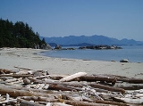
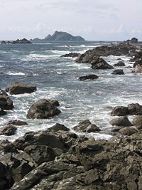
Brooks Peninsula juts 20 kilometres (12 mi) into the Pacific Ocean and has a rugged and varied coastline, with long fjords and sandy beaches. The inland is seldom-explored and densely wooded with mostly old growth forest
Old growth forest
An old-growth forest is a forest that has attained great age , and thereby exhibits unique ecological features. An old growth forest has also usually reached a climax community...
.
The highest point is a sub-peak of Snowsaddle Mountain at 1143m (3,750 ft) elevation. Mountains in the park, known as the Refugium Range
Refugium Range
The Refugium Range is a low, small mountain range comprising the mountains/hills of the Brooks Peninsula on northern Vancouver Island, British Columbia, Canada. It has an area of and is a subrange of the Vancouver Island Ranges which in turn form part of the Insular Mountains...
, include Klaskish (963m or 3,159 ft), Nunatak (930m or 3,051 ft), and Doom
Doom Mountain
Doom Mountain is a mountain on the Brooks Peninsula on Vancouver Island in British Columbia, Canada. It was so named by Dr. Richard Hebda of the Royal British Columbia Museum because of the forbidding appearance of sheer cliffs, and because the mountain top was usually shrouded in cloud while the...
(787m or 2,582 ft). Peaks in the area higher than 700m (2,300 ft) were above the glaciers during the last ice age and are therefore a refugium with unique plants..
Conservation
The park preserves the peninsula’s pristine wilderness landscape, which contains the Refugium Range
Refugium Range
The Refugium Range is a low, small mountain range comprising the mountains/hills of the Brooks Peninsula on northern Vancouver Island, British Columbia, Canada. It has an area of and is a subrange of the Vancouver Island Ranges which in turn form part of the Insular Mountains...
of the Vancouver Island Ranges
Vancouver Island Ranges
The Vancouver Island Ranges, formerly called the Vancouver Island Mountains, is a mountain range extending along the length of Vancouver Island which has an area of 31,788 km² . The Vancouver Island Ranges comprise the central and largest part of the island...
and Coastal Western Hemlock
Western Hemlock
Tsuga heterophylla. the Western Hemlock, is a species of hemlock native to the west coast of North America, with its northwestern limit on the Kenai Peninsula, Alaska, and its southeastern limit in northern Sonoma County, California.-Habitat:...
biogeoclimatic zone.
Cultural Heritage
Kyuquot/Cheklesahht First Nation
The Kyuquot/Cheklesath First Nation is a First Nations government based at Kyuquot, located on the outer coast of Kyuquot Sound, on the west coast of Vancouver Island in British Columbia, Canada...
and Quatsino First Nation
Quatsino First Nation
The Quatsino First Nation is the First Nations band government of the Gwat'sinux subgroup of the Kwakwaka'wakw peoples, based on the west coast of northern Vancouver Island in British Columbia, Canada, focused on the community of Coal Harbour in Quatsino Sound...
s band governments. Battle Bay in the southern portion of the park is rich in First Nations cultural history. Many battles were fought at this location in order to retain control of this prosperous area. First Nations reserves located adjacent to the southern portion of Brooks Peninsula Provincial Park are not for recreational use. Visitors are encouraged to contact the Kyuquot/Cheklesahht First Nation band office in Kyuquot prior to exploring Brooks Peninsula.
Recreation
Brooks Peninsula is infrequently visited; its surrounding waters however provide superb kayaking and canoeing. It is entirely undeveloped and has no marked trails and no facilities, although in some locations ocean debris is placed at known trail heads.Camping is permitted anywhere in the park, but made complicated due to the remoteness, difficulty of access, and lack of facilities.
Nearby Solander Island is an Ecological Reserve and access is prohibited.