

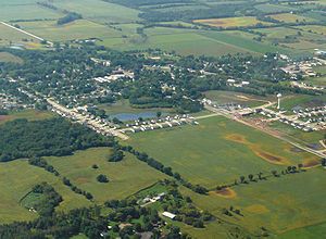
Brooklyn (village), Wisconsin
Encyclopedia
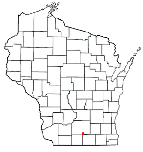
Dane County, Wisconsin
As of the census of 2000, there were 426,526 people, 173,484 households, and 100,794 families residing in the county. The population density was 355 people per square mile . There were 180,398 housing units at an average density of 150 per square mile...
and Green
Green County, Wisconsin
Green County is a county located in the U.S. state of Wisconsin. As of 2000, the population was 33,647. Its county seat is Monroe.-Geography:According to the U.S...
Counties in the U.S. state
U.S. state
A U.S. state is any one of the 50 federated states of the United States of America that share sovereignty with the federal government. Because of this shared sovereignty, an American is a citizen both of the federal entity and of his or her state of domicile. Four states use the official title of...
of Wisconsin
Wisconsin
Wisconsin is a U.S. state located in the north-central United States and is part of the Midwest. It is bordered by Minnesota to the west, Iowa to the southwest, Illinois to the south, Lake Michigan to the east, Michigan to the northeast, and Lake Superior to the north. Wisconsin's capital is...
. At the 2000 census, 502 Brooklyn residents lived in Dane County, and 414 in Green County, with a total population of 916.
The Dane County portion of Brooklyn is part of the Madison
Madison, Wisconsin
Madison is the capital of the U.S. state of Wisconsin and the county seat of Dane County. It is also home to the University of Wisconsin–Madison....
Metropolitan Statistical Area
Madison metropolitan area
The Madison Metropolitan Statistical Area, as defined by the United States Census Bureau, is an area consisting of three counties in Wisconsin, anchored by the city of Madison. As of the 2010 census, the MSA had a population of 568,593.-Definitions:...
, while the Green County portion is part of the Monroe
Monroe, Wisconsin
Monroe, known as "the Swiss Cheese Capital of the USA", is a city in and the county seat of Green County, Wisconsin, United States. The population, was 10,843 at the 2000 census. The city is located partially within the Town of Monroe and partially in the Town of Clarno.-Geography:Monroe is located...
Micropolitan Statistical Area.
The village was incorporated in 1905.
Geography
Brooklyn is located at 42°51′13"N 89°22′11"W (42.853600, -89.369689).According to the United States Census Bureau
United States Census Bureau
The United States Census Bureau is the government agency that is responsible for the United States Census. It also gathers other national demographic and economic data...
, the village has a total area of 1.1 square miles (2.8 km²), all land.
All mailing addresses in the village use ZIP code
ZIP Code
ZIP codes are a system of postal codes used by the United States Postal Service since 1963. The term ZIP, an acronym for Zone Improvement Plan, is properly written in capital letters and was chosen to suggest that the mail travels more efficiently, and therefore more quickly, when senders use the...
53521.
The village straddles the boundary between the Sugar
Sugar River (Wisconsin)
The Sugar River is a tributary of the Pecatonica River, approximately long, in the U.S. states of Wisconsin and Illinois.It rises in the hills of southwest Wisconsin, in southwest Dane County, approximately southwest of Madison. The headwaters are at the southern terminus of the last North...
-Pecatonica
Pecatonica River
The Pecatonica River is a tributary of the Rock River, long, in southern Wisconsin and northern Illinois in the United States.The word Pecatonica is an anglicization of two Algonquian language words: Bekaa , which means "slow", and niba, which means "water", forming the conjunction Bekaaniba or...
river basin (Allen Creek and Middle Sugar River watershed) draining to the west, and Lower Rock
Rock River (Illinois)
The Rock River is a tributary of the Mississippi River, approximately long, in the U.S. states of Wisconsin and Illinois. It rises in southeast Wisconsin, in the Theresa Marsh near Theresa, Wisconsin in northeast Dodge County, Wisconsin approximately south of Fond du Lac, Wisconsin...
river basin (Badfish Creek watershed) draining to the east. http://www.danewaters.com/resource/WatershedMap.aspx
Demographics
As of the censusCensus
A census is the procedure of systematically acquiring and recording information about the members of a given population. It is a regularly occurring and official count of a particular population. The term is used mostly in connection with national population and housing censuses; other common...
of 2000, there were 916 people, 343 households, and 255 families residing in the village. The population density
Population density
Population density is a measurement of population per unit area or unit volume. It is frequently applied to living organisms, and particularly to humans...
was 837.4 people per square mile (324.5/km²). There were 351 housing units at an average density of 320.9 per square mile (124.3/km²). The racial makeup of the village was 98.25% White, 0.22% African American, 0.44% Asian, 0.33% from other races
Race (United States Census)
Race and ethnicity in the United States Census, as defined by the Federal Office of Management and Budget and the United States Census Bureau, are self-identification data items in which residents choose the race or races with which they most closely identify, and indicate whether or not they are...
, and 0.76% from two or more races. Hispanic or Latino of any race were 1.42% of the population.
There were 343 households out of which 43.1% had children under the age of 18 living with them, 60.3% were married couples
Marriage
Marriage is a social union or legal contract between people that creates kinship. It is an institution in which interpersonal relationships, usually intimate and sexual, are acknowledged in a variety of ways, depending on the culture or subculture in which it is found...
living together, 9.0% had a female householder with no husband present, and 25.4% were non-families. 18.7% of all households were made up of individuals and 8.7% had someone living alone who was 65 years of age or older. The average household size was 2.67 and the average family size was 3.08.
In the village the population was spread out with 30.1% under the age of 18, 5.9% from 18 to 24, 39.0% from 25 to 44, 16.6% from 45 to 64, and 8.4% who were 65 years of age or older. The median age was 33 years. For every 100 females there were 104.0 males. For every 100 females age 18 and over, there were 104.5 males.
The median income for a household in the village was $48,056, and the median income for a family was $51,607. Males had a median income of $34,934 versus $25,893 for females. The per capita income
Per capita income
Per capita income or income per person is a measure of mean income within an economic aggregate, such as a country or city. It is calculated by taking a measure of all sources of income in the aggregate and dividing it by the total population...
for the village was $19,480. About 1.1% of families and 2.9% of the population were below the poverty line, including 1.5% of those under age 18 and 18.2% of those age 65 or over.
Communication
VerizonVerizon North
Verizon North LLC is a Verizon operating company providing local telephone service to former GTE customers in Pennsylvania.-History:In 2010, when the original Verizon North was sold to Frontier Communications, whose service region included Pennsylvania...
owns a telephone exchange in the village. Its area code
Telephone numbering plan
A telephone numbering plan is a type of numbering scheme used in telecommunications to allocate telephone numbers to subscribers and to route telephone calls in a telephone network. A closed numbering plan, such as found in North America, imposes a fixed total length to numbers...
is 608, and its exchange prefix is 455. U.S. Cellular
U.S. Cellular
United States Cellular Corporation, d.b.a. U.S. Cellular , owns and operates the sixth largest wireless telecommunications network in the United States, behind Verizon Wireless, AT&T Mobility, Sprint Nextel, T-Mobile USA, and Metro PCS. , they serve about 6.1 million customers in 126 markets in...
owns an antenna for wireless telephone services in the village.
Roads
Wisconsin state highways 92 and 104 intersect in the village. Dane county highway MM terminates at that intersection. United States highway 14 passes to the east of Brooklyn.Railways
An abandoned Chicago & NW RailwayChicago and North Western Railway
The Chicago and North Western Transportation Company was a Class I railroad in the Midwest United States. It was also known as the North Western. The railroad operated more than of track as of the turn of the 20th century, and over of track in seven states before retrenchment in the late 1970s...
line runs through the village.
Municipal property
There are two parks in the village, Smithfield Park on the east side, and Brooklyn Jaycee Park near the center. Smithfield Park contains a basketball court, a picnic pavilion, public lavatories with drinking fountains, and a playground. Brooklyn Jaycee Park is adjacent to the American Legion softball diamond.The Brooklyn Community Building was built in 1938.
Education
Brooklyn Elementary School, a public school, is part of the Oregon School DistrictOregon School District
Oregon Area School District is located south of Madison, in the village of Oregon, Wisconsin. A publicly elected school board provides direction and oversight, with a superintendent heading the organization's administration for over 3600 students and 6 schools....
.