
Bronington
Encyclopedia
Bronington is a local government community
, the lowest tier of local government, part of Wrexham County Borough in Wales
. The community has an area of 3,482 hectare
s and a population of 1,228 (2001 Census
).
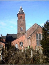
The village church, Holy Trinity, was converted from a former brick tithe barn
in 1836. To the north-east of the village is Iscoyd Hall, a stately home
with surrounding parkland which was built around 1740 and enlarged in the 19th century. To the south of the village is Fenn's Moss
, an area of peat bog stretching over into Shropshire
, which was declared a National Nature Reserve
in 1996 because of its importance for wildlife.
Community (Wales)
A community is a division of land in Wales that forms the lowest-tier of local government in Wales. Welsh communities are analogous to civil parishes in England....
, the lowest tier of local government, part of Wrexham County Borough in Wales
Wales
Wales is a country that is part of the United Kingdom and the island of Great Britain, bordered by England to its east and the Atlantic Ocean and Irish Sea to its west. It has a population of three million, and a total area of 20,779 km²...
. The community has an area of 3,482 hectare
Hectare
The hectare is a metric unit of area defined as 10,000 square metres , and primarily used in the measurement of land. In 1795, when the metric system was introduced, the are was defined as being 100 square metres and the hectare was thus 100 ares or 1/100 km2...
s and a population of 1,228 (2001 Census
United Kingdom Census 2001
A nationwide census, known as Census 2001, was conducted in the United Kingdom on Sunday, 29 April 2001. This was the 20th UK Census and recorded a resident population of 58,789,194....
).
The village church, Holy Trinity, was converted from a former brick tithe barn
Tithe barn
A tithe barn was a type of barn used in much of northern Europe in the Middle Ages for storing the tithes - a tenth of the farm's produce which had to be given to the church....
in 1836. To the north-east of the village is Iscoyd Hall, a stately home
Stately home
A stately home is a "great country house". It is thus a palatial great house or in some cases an updated castle, located in the British Isles, mostly built between the mid-16th century and the early part of the 20th century, as well as converted abbeys and other church property...
with surrounding parkland which was built around 1740 and enlarged in the 19th century. To the south of the village is Fenn's Moss
Fenn's, Whixall and Bettisfield Mosses NNR
Fenn's, Whixall and Bettisfield Mosses National Nature Reserve is a National Nature Reserve which straddles the border between England and Wales, near Whixall and Ellesmere in Shropshire, England....
, an area of peat bog stretching over into Shropshire
Shropshire
Shropshire is a county in the West Midlands region of England. For Eurostat purposes, the county is a NUTS 3 region and is one of four counties or unitary districts that comprise the "Shropshire and Staffordshire" NUTS 2 region. It borders Wales to the west...
, which was declared a National Nature Reserve
National Nature Reserve
For details of National nature reserves in the United Kingdom see:*National Nature Reserves in England*National Nature Reserves in Northern Ireland*National Nature Reserves in Scotland*National Nature Reserves in Wales...
in 1996 because of its importance for wildlife.
Sources
- Davies, John; Jenkins, Nigel; Baines, Menna & Lynch, Peredur I. (2008) The Welsh Academy Encyclopaedia of Wales, University of Wales Press, Cardiff.