
Bridges of Brisbane
Encyclopedia
The Brisbane River
, running through Brisbane
, Queensland
, Australia
, is crossed by sixteen major bridges, from the Sir Leo Hielscher Bridges
downsteam to the Centenary
upsteam. The river meanders through an urban area that comprises 1.8 million people.
There are two smaller crossings in the west of Brisbane City in the suburb of Mount Crosby
: the Mount Crosby Weir
, and Colleges Crossing
(which straddles the boundary between Brisbane and Ipswich
).
. From Cairns Street Kangaroo Point a new bridge will connect to the end of the floating riverwalk at Merthyr Road, New Farm
. And from Merthyr Road, Teneriffe
a new bridge will connect to Hardcaste Park, Hawthorne
(near Lindsay Street). These new bridges will create a greenway
corridor over 5 green bridges
from Morningside
, through Hawthorne, Teneriffe, New Farm, Kangaroo Point, City, Northbank, South Bank
, Dutton Park
and Boggo Road to the University of Queensland
.
and Wivenhoe Dam
a number of others have been proposed.
The Goodna Bypass is designed to relieve congestion on the Ipswich Motorway
and will have four new bridges over the river (but no access to or from the north-western suburbs). Land acquisitions were underway in 2010 to create the future transport corridor. As of 2010, there is no date or funding provided to commence the construction of the Goodna Bypass.
The Western Bypass would have included a crossing of the river but has been cancelled.
The existing crossings on this section of the river are listed below (note: coordinates are derived from Google Earth).
The more significant crossings from Lake Wivenhoe to Moore
are listed below.
to the Mount Stanley State Forest. It crosses the river 12 times between Linville and its end, where it splits into Western Branch Road and Eastern Branch Road. Western Branch Road follows the west branch of the river to its source in Elgin Vale State Forest, north-west of Mount Stanley, crossing it 28 times. Eastern Branch Road follows the east branch most of the way to its source south-east of Mount Stanley, crossing it about 20 times before it ends.
Brisbane River
The Brisbane River is the longest river in south east Queensland, Australia, and flows through the city of Brisbane, before emptying into Moreton Bay. John Oxley was the first European to explore the river who named it after the Governor of New South Wales, Thomas Brisbane in 1823...
, running through Brisbane
Brisbane
Brisbane is the capital and most populous city in the Australian state of Queensland and the third most populous city in Australia. Brisbane's metropolitan area has a population of over 2 million, and the South East Queensland urban conurbation, centred around Brisbane, encompasses a population of...
, Queensland
Queensland
Queensland is a state of Australia, occupying the north-eastern section of the mainland continent. It is bordered by the Northern Territory, South Australia and New South Wales to the west, south-west and south respectively. To the east, Queensland is bordered by the Coral Sea and Pacific Ocean...
, Australia
Australia
Australia , officially the Commonwealth of Australia, is a country in the Southern Hemisphere comprising the mainland of the Australian continent, the island of Tasmania, and numerous smaller islands in the Indian and Pacific Oceans. It is the world's sixth-largest country by total area...
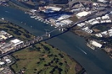
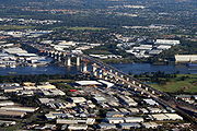
, is crossed by sixteen major bridges, from the Sir Leo Hielscher Bridges
Gateway Bridge, Brisbane
The Sir Leo Hielscher Bridges are a pair of road bridges on the Gateway Motorway , which skirts the eastern suburbs of Brisbane, Queensland, Australia. They are the most eastern crossing of the Brisbane River, the closest to Moreton Bay, crossing at the Quarries Reach, between Eagle Farm and Murarrie...
downsteam to the Centenary
Centenary Bridge, Brisbane
The Centenary Bridge is a motorway crossing of the Brisbane River.As it forms part of Brisbane's Centenary Motorway it is used primarily by vehicular traffic, although it includes footpaths for pedestrian traffic....
upsteam. The river meanders through an urban area that comprises 1.8 million people.
There are two smaller crossings in the west of Brisbane City in the suburb of Mount Crosby
Mount Crosby, Queensland
Mount Crosby is a mountain and outer suburb of Brisbane, Australia located south-west of the Brisbane CBD.-Geography:The Brisbane River, Mount Crosby and the adjoining State Forest are the dominant natural features of the area.-History:...
: the Mount Crosby Weir
Mount Crosby Weir
The Mount Crosby Weir is weir on the Brisbane River at Mount Crosby in South East Queensland, Australia. The project was instigated by John Petrie at the end of the 19th century...
, and Colleges Crossing
Colleges Crossing
Colleges Crossing is a Brisbane River bridge that crosses at Chuwar, a suburb of Ipswich in South East Queensland, Australia. The location is the point where the tidal influences no longer affect the waters of the river. The road across the bridge is Mount Crosby Road...
(which straddles the boundary between Brisbane and Ipswich
Ipswich, Queensland
Ipswich is a city in South-East Queensland, Australia. Situated along the Bremer River Valley approximately 40 kilometres away from the state's capital Brisbane. The suburb by the same name forms the city's Central Business District and administrative centre...
).
Major bridges
| # | Name | Usage | Description | Photo |
|---|---|---|---|---|
| 1 | Sir Leo Hielscher (two bridges) — original bridge formerly known as the Gateway Bridge |
vehicles, cyclists & pedestrians |
Original bridge opened January 1986. Duplicate bridge opened May 2010. Concrete box girder design. 260 metre (853 ft) main span. |
 |
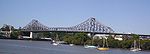
| 2 | Story Story Bridge, Brisbane The Story Bridge is a cantilever bridge spanning the Brisbane River. Part of Bradfield Highway , it connects Fortitude Valley to Kangaroo Point. Before the opening of the Sydney Harbour Bridge in 1932 the Government of Queensland asked John Bradfield to design a new bridge in Brisbane... |
vehicles & pedestrians |
Opened July 1940. Steel truss design. 777 metres (2,549 ft) long with a 282 metre (925 ft) main span. |
 |
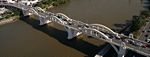
| 3 | Captain Cook Captain Cook Bridge, Brisbane The Captain Cook Bridge is a motorway bridge over the Brisbane River in Brisbane, Australia. It was built exclusively for vehicular traffic and was opened in 1972. The bridge crosses at the South Brisbane Reach of the river, linking Gardens Point to Woolloongabba.Captain Cook Bridge actually... |
vehicles | Opened 1972. Concrete box girder design. 555 metres (1,821 ft) long with 183 metre (600 ft) main span. |
 |
| 4 | Goodwill Goodwill Bridge, Brisbane The Goodwill Bridge is a pedestrian and cyclist bridge which spans the Brisbane River in Brisbane Australia, linking the South Bank Parklands / Queensland Museum on the southside, to the Gardens Point Campus of the Queensland University of Technology on the northside.The Goodwill Bridge was opened... |
pedestrians & cyclists |
Opened October 2001. 450 metres (1,476 ft) long with 102 metre (335 ft) main span. |
 |
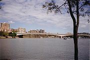
| 5 | Victoria Victoria Bridge, Brisbane The Victoria Bridge is a vehicular and pedestrian bridge over the Brisbane River. The current bridge, opened in 1969, is the third permanent crossing erected at this location... |
vehicles, cyclists & pedestrians |
Opened 1969. Replaced its namesake. 146.3 metre (480 ft) main span. |
|
| 6 | Kurilpa | pedestrians & cyclists |
Opened October 2009. 'Tensegrity' design. 425m long pathway |
 |
| 7 | William Jolly William Jolly Bridge, Brisbane The William Jolly Bridge is a vehicular and pedestrian bridge over the Brisbane River in Brisbane, Queensland, Australia. It is a steel frame arch bridge with an unusual concrete veneer and was opened to traffic on 30 March 1932 by Sir John Goodwin, the Governor of Queensland.When opened, during... — also known as Grey Street Bridge |
vehicles & pedestrians | Opened March 1932. Concrete arch design. 498 metres (1,634 ft) long with a 73 metre (240 ft) main span. |
 |
| 8 | Merivale Merivale Bridge, Brisbane The Merivale Bridge is a double track railway bridge crossing the Brisbane River. It crosses the Milton Reach of the river, slightly to the west of the William Jolly Bridge. Exclusively a railway crossing, it is located between the stations of South Brisbane and Roma Street, linking the northern... |
rail | Opened November 1978. Tied steel arch design. Main span 132 metre (433 ft). |
 |
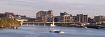
| 9 | Go Between — formerly known as Hale Street Link. |
vehicles, cyclists & pedestrians |
Opened 5 July 2010. Concrete box girder balanced cantilever design. |
|
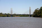
| 10 | Eleanor Schonell — formerly known as Green Bridge. |
buses, cyclists & pedestrians |
Opened December 2006. Cable-stayed design. 390 metres (1,280 ft) long. |
 |
| 11 | Jack Pesch Jack Pesch Bridge, Brisbane The Jack Pesch Bridge is a bridge for pedestrians and cyclists which crosses the Brisbane River. The bridge is named in honour of Jack Pesch, a cycling champion during the 1930s... |
cyclists & pedestrians |
Opened October 1998. Steel cable-stay design. |
 |
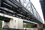
| 12 | Albert Albert Bridge, Brisbane The Albert Bridge is a railway bridge of steel truss design crossing the Brisbane River, Queensland, Australia. The Albert Bridge links Indooroopilly and Chelmer stations, and has two long spans with one central pier.... |
rail | Opened 1895. Steel truss design. Replaced its namesake. 208 metres (682 ft) long with two spans each 103.7 metres (340 ft). |
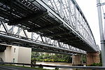 |
| 13 | Indooroopilly Railway Indooroopilly Railway Bridge, Brisbane The Indooroopilly Railway Bridge is a railway bridge of steel truss design which crosses the Brisbane River, Queensland, Australia. The Indooroopilly Railway Bridge links Indooroopilly and Chelmer stations, and has two long spans with one central pier... |
rail | Opened 1957. Steel truss design. 208.5 metres (684 ft) long with two equal spans. |
 |
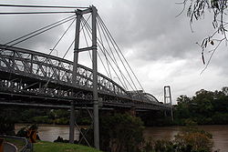
| 14 | Walter Taylor Walter Taylor Bridge, Brisbane The Walter Taylor Bridge is a suspension bridge crossing the Brisbane River between Indooroopilly and Chelmer in Brisbane, Queensland, Australia... |
vehicles & pedestrians |
Opened February 1936. Suspension design. Main span 183 metres (600 ft). The bridge's towers are occupied. |
 |
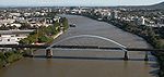
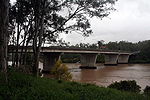
| 15 | Centenary Centenary Bridge, Brisbane The Centenary Bridge is a motorway crossing of the Brisbane River.As it forms part of Brisbane's Centenary Motorway it is used primarily by vehicular traffic, although it includes footpaths for pedestrian traffic.... |
vehicles, cyclists & pedestrians |
Concrete girder |
 |
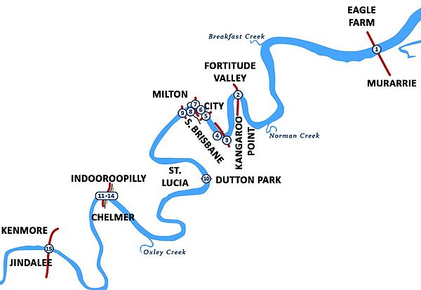
Map
Future bridges
In 2007 the Smart State Council announced plans for a series of new green mode bridges for Brisbane. New bridges include a connection from Margaret Street near the Stock Exchange in the City to Thornton Street, Kangaroo PointKangaroo Point, Queensland
Kangaroo Point is a suburb of Brisbane, Queensland, Australia located directly east across the Brisbane River from the Brisbane central business district.- Geography :...
. From Cairns Street Kangaroo Point a new bridge will connect to the end of the floating riverwalk at Merthyr Road, New Farm
New Farm, Queensland
New Farm is an inner suburb of Brisbane, Australia, located 2 km east of the Brisbane CBD on a large bend of the Brisbane River. New Farm is partly surrounded by the Brisbane River, with land access from the north west through Fortitude Valley and from the north through...
. And from Merthyr Road, Teneriffe
Teneriffe, Queensland
Teneriffe is an inner city suburb in Brisbane, Australia. Situated next to Teneriffe are the suburbs of Newstead, Fortitude Valley, Bowen Hills and New Farm...
a new bridge will connect to Hardcaste Park, Hawthorne
Hawthorne, Queensland
Hawthorne is an inner riverside suburb of Brisbane, Australia. It is east of the Brisbane central business district.Hawthorne started as a farming district in the 1860s, and was gradually subdivided as Brisbane grew...
(near Lindsay Street). These new bridges will create a greenway
Greenway (landscape)
A greenway is a long, narrow piece of land, often used for recreation and pedestrian and bicycle user traffic, and sometimes for streetcar, light rail or retail uses.- Terminology :...
corridor over 5 green bridges
Green Bridge
-Structures:*Wildlife crossing, a bridge built to allow wildlife to move over highways safely*Pedestrian separation structure, a structure that removes pedestrians from a vehicle roadway-Bridges:in Australia...
from Morningside
Morningside, Queensland
Morningside is a suburb in the south-east of Brisbane, Australia, surrounded by Cannon Hill, Norman Park and Hawthorne. Morningside's postal code is 4170. The old suburb of Colmslie was merged into Morningside....
, through Hawthorne, Teneriffe, New Farm, Kangaroo Point, City, Northbank, South Bank
South Bank, Queensland
South Bank is a cultural, educational and recreational precinct in Brisbane, Queensland, Australia. The precinct is located in the suburb of South Brisbane, on the southern bank of the Brisbane River.-South Bank Parklands:...
, Dutton Park
Dutton Park, Queensland
Dutton Park is a suburb of Brisbane, Australia located 5 km south of the Brisbane CBD. The suburb is predominantly residential, with some light industrial and commercial areas....
and Boggo Road to the University of Queensland
University of Queensland
The University of Queensland, also known as UQ, is a public university located in state of Queensland, Australia. Founded in 1909, it is the oldest and largest university in Queensland and the fifth oldest in the nation...
.
Cross river tunnels
The Clem Jones Tunnel is currently the only cross river tunnel built in Brisbane. It opened on 16 March 2010.Crossings between the Centenary Bridge and Wivenhoe Dam
In addition to the existing bridges between Centenary BridgeCentenary Bridge, Brisbane
The Centenary Bridge is a motorway crossing of the Brisbane River.As it forms part of Brisbane's Centenary Motorway it is used primarily by vehicular traffic, although it includes footpaths for pedestrian traffic....
and Wivenhoe Dam
Wivenhoe Dam
Wivenhoe Dam is a dam across the Brisbane River a little way upstream from Locker Creek. The dam creates the artificial Lake Wivenhoe. The dam wall is located about by road from the centre of Brisbane, Queensland, Australia....
a number of others have been proposed.
The Goodna Bypass is designed to relieve congestion on the Ipswich Motorway
Ipswich Motorway
The M7 runs from the junction of Ipswich Road and Granard Road to the M2 Logan Motorway interchange. It is then signed M2 until the junction of the Warrego Highway and the Cunningham Highway between Brisbane and Ipswich in South East Queensland, Australia.It initially passes through the suburbs of...
and will have four new bridges over the river (but no access to or from the north-western suburbs). Land acquisitions were underway in 2010 to create the future transport corridor. As of 2010, there is no date or funding provided to commence the construction of the Goodna Bypass.
The Western Bypass would have included a crossing of the river but has been cancelled.
The existing crossings on this section of the river are listed below (note: coordinates are derived from Google Earth).
| Name of crossing and/or road | Coordinates | Description and/or purpose |
|---|---|---|
| Moggill Ferry Moggill Ferry The Moggill Ferry is a cable ferry crossing the Brisbane River between the suburbs of Moggill in Brisbane and Riverview in Ipswich, Queensland Australia. The iconic ferry is owned by Stradbroke Ferries and can carry up to 20 vehicles per crossing.... |
27°35′41"S 152°51′22"E | Links Riverview Riverview, Queensland Riveview is a suburb of Ipswich, Queensland, Australia.-Transport:Riverview railway station provides access to regular Citytrain services to Brisbane, Ipswich and Rosewood via Ipswich.-External links:*... to Moggill Moggill, Queensland Moggill is one of Brisbane's western suburbs, about from the CBD. It comprises a mixture of small-lot and acreage residential homes along with a small number of remaining farms... |
| Mount Crosby Road at Colleges Crossing Colleges Crossing Colleges Crossing is a Brisbane River bridge that crosses at Chuwar, a suburb of Ipswich in South East Queensland, Australia. The location is the point where the tidal influences no longer affect the waters of the river. The road across the bridge is Mount Crosby Road... |
27°33′25"S 152°48′15"E | Links North Tivoli North Tivoli, Queensland -References:... to Mount Crosby Mount Crosby, Queensland Mount Crosby is a mountain and outer suburb of Brisbane, Australia located south-west of the Brisbane CBD.-Geography:The Brisbane River, Mount Crosby and the adjoining State Forest are the dominant natural features of the area.-History:... |
| Allawah Road across Mount Crosby Weir Mount Crosby Weir The Mount Crosby Weir is weir on the Brisbane River at Mount Crosby in South East Queensland, Australia. The project was instigated by John Petrie at the end of the 19th century... |
27°32′14"S 152°43′47"E | Adjacent to Mount Crosby Pumping Station |
| Kholo Bridge, Kholo Road | 27°29′40"S 152°44′51"E | Links North Ipswich North Ipswich, Queensland North Ipswich is a suburb of Ipswich, Queensland, Australia. This is the birthplace of Queensland Rail. The original site is now the site of Riverlink shopping centre on The Terrace and the current site is used as a joint facility containing the very popular multi award winning Rail Workshop... to Kholo Kholo, Queensland Kholo is an outer suburb of Brisbane, Australia located 22 km south-west of the Brisbane CBD. Kholo became part of the Brisbane City in 1999.-External links:* *... |
| McMullen Road (ford, no longer used) | 27°33′54"S 152°44′51"E | Links Borallon to farms at Lake Manchester |
| Summervilles Road (Burtons Bridge) | 27°29′58"S 152°41′22"E | Links Borallon Borallon, Queensland Borallon is a rural suburb of Somerset Region, Queensland, Australia.The Borallon Correctional Centre prison facility is located in Borallon.-References:* http://www.nrw.qld.gov.au/property/placenames/detail.php?id=3862... to farms at Lake Manchester Lake Manchester, Queensland Lake Manchester is an outer suburb of Brisbane, Australia. It is west of the CBD next to Brisbane Forest. The suburb Lake Manchester is named after the Lake Manchester Dam constructed between 1912–1916.-External links:* *... , near Lake Manchester Dam Lake Manchester Dam Lake Manchester is built on Cabbage Tree Creek in the suburb of the same name, not far above its confluence with the Brisbane River in South East Queensland, Australia. The dam wall is a concrete gravity-section type. Its original purpose was to supplement supplies when the flow of the Brisbane... |
| Banks Creek Road (Savages Crossing) | 27°26′37"S 152°40′13"E | Links Fernvale Fernvale, Queensland Fernvale is a town located on the Brisbane Valley Highway in South East Queensland. The town is part of the Somerset Region.Situated a few kilometres from the Brisbane River, it is 30 km away from Ipswich and 60 km away from Brisbane. It is 80 km away from Toowoomba and 120 km... to farms at Banks Creek |
| Brisbane Valley Highway Brisbane Valley Highway The Brisbane Valley Highway is a state highway in Queensland. It leaves the Warrego Highway near Ipswich and travels in a northwesterly direction, following the Brisbane River until it reaches the D'Aguilar Highway about south-east of Moore, where it ends... |
27°25′51"S 152°38′22"E | Between Fernvale and Wivenhoe Dam, taking the highway east of the river |
| Wivenhoe Pocket Road (Twin Bridges) | 27°26′13"S 152°38′00"E | Links Fernvale to farms in Wivenhoe Pocket, crossing the river via an island |
| Brisbane Valley Highway across Wivenhoe Dam | 27°23′40"S 152°36′33"E | The highway runs on top of the dam wall for 2.3 kilometres |
Crossings from Lake Wivenhoe to Moore
When Lake Wivenhoe is full the waters extend many kilometres up the river. The first crossing upstream from the lake is a high level bridge built in conjunction with the dam to raise the Esk Kilcoy Road well above the maximum level of the lake. Several minor crossings of this section of the river shown on maps are omitted from the list below. The omitted crossings belong to one of the following groups:- Former low level crossings now covered (most of the time) by the waters of Lake Wivenhoe.
- Public or private roads that provide access to farms on the eastern side of the river.
- Private roads or tracks that link parts of farms that are astride the river.
The more significant crossings from Lake Wivenhoe to Moore
Moore, Queensland
Moore is a town in South East Queensland, north west of Brisbane. It is situated at the base of the Balfour Range on the D'Aguilar Highway, between Esk in the Brisbane River valley and Yarraman in the South Burnett....
are listed below.
| Name of crossing and/or road | Coordinates | Description and/or purpose |
|---|---|---|
| Esk Kilcoy Road | 27°08′18"S 152°30′36"E | Links Esk Esk, Queensland Esk is a town in the West Moreton region of South East Queensland, approximately 90 km northwest of Ipswich on the Brisbane Valley Highway. It was named after the River Esk in Scotland and England. It is the administrative centre of the Somerset Region... to Kilcoy Kilcoy, Queensland Kilcoy is a small farming town and part of the Somerset Region Local Government Area in South East Queensland, Australia. The township lies on the D'Aguilar Highway, 94 km north west of the state capital, Brisbane, and just to the north of Lake Somerset... via Somerset Dam |
| Gregors Creek Road | 26°59′14"S 152°23′54"E | Links Brisbane Valley Highway to farms at Gregors Creek, and provides an alternate route to Kilcoy |
| D'Aguilar Highway D'Aguilar Highway The D'Aguilar Highway is a two-lane highway linking the Bruce Highway near Caboolture with Kingaroy in the state of Queensland, Australia. Major towns along the route include Woodford, Kilcoy, Yarraman, Nanango and Kingaroy... |
26°56′39"S 152°21′33"E | Links Brisbane Valley Highway to Kilcoy |
Upstream from Moore
Linville Road follows the river from Moore through LinvilleLinville, Queensland
-History:On 19 August 1891, the Balfour brothers - John, Charles and Robert, took up Colinton run which included the present site of the town of Linville. The Balfours originally intended to build their homestead where Linville now stands but decided to establish it instead about 10 kilometres to...
to the Mount Stanley State Forest. It crosses the river 12 times between Linville and its end, where it splits into Western Branch Road and Eastern Branch Road. Western Branch Road follows the west branch of the river to its source in Elgin Vale State Forest, north-west of Mount Stanley, crossing it 28 times. Eastern Branch Road follows the east branch most of the way to its source south-east of Mount Stanley, crossing it about 20 times before it ends.
External links
- Historical Brisbane River Map - shows the positions of Brisbane bridges on the river
- Images of Brisbane bridges - a slideshow of historical images of Brisbane bridges from Picture Queensland, State Library of Queensland